
Dortmund-Ems Canal Route
| Dortmund-Ems Canal Route | |
|---|---|

|
|
| overall length | 350 km |
| location |
|
| map | |
| Link on map | |
| Starting point | Dortmund |
| Target point | North dike |
| Places along the way | Waltrop , Datteln , Olfen , Lüdinghausen ( Bf ), Senden , Münster ( Bf ), Rheine ( Bf ), Lingen (Bf), Meppen (Bf), Haren , Lathen ( Bf ), Dörpen ( Bf ), Rhede , Papenburg ( Bf ), Weener ( Bf ), Leer ( Bf ), Jemgum , Oldersum , Emden ( Bf ), Werdenum , Upgant-Schott , Hage , Hinte , Samtgemeinde Brookmerland , Norden ( Bf ) |
| Flooring | mostly paved |
| difficulty | light |
| Traffic volume | low |
| Website URL | Dortmund-Ems Canal Route |
The Dortmund-Ems-Canal-Route (abbreviated: DEK-Route), also called Dortmund-Ems-Kanal-Radweg , is a 350-kilometer long and almost incline-free long -distance cycle path in Germany that connects the Ruhr area with the North Sea coast . The route established in 1999 for the 100th anniversary of the Dortmund-Ems Canal runs mainly directly along the canal and in the north along the Ems to Emden and to Emden through the municipalities of Krummhörn and Norden in the Aurich district . The two destination and end locations are Dortmund and Norddeich .
Characteristic
The Dortmund-Ems Canal Route connects the Ruhr area with East Friesland and the North Sea. There is shipping traffic on the canal and the Ems, locks, ports and weirs. The route leads past industrial monuments through the park landscape of the Münsterland and the Emsland with its many rivers and canals to East Frisia.
The route has no significant incline and runs away from car traffic on paved or paved paths. It is suitable for families with children and cyclists of all ages.
According to ADFC information are:
- The degree of difficulty: approx. 91% easy, 9% medium
- The condition of the route: approx. 35% suitable for road bikes, 65% touring bikes are recommended
- The traffic load: approx. 99% no to low, 1% moderate
- 837 m ascent; 925 m slopes
Route
The cycle path leads through the federal states of North Rhine-Westphalia and Lower Saxony : from the Ruhr area through the Münsterland, through Emsland , through East Frisia to the Wadden Sea on the North Sea coast. In North Rhine-Westphalia the route runs through some districts and cities in the administrative districts of Arnsberg and Münster , in Lower Saxony through the districts of Emsland , Leer and Aurich and the city of Emden .
Most of the route - from Dortmund to Dörpen im Emsland - leads along the Dortmund-Ems Canal, then around 60 km to Emden - together with the Ems cycle path - along the Ems and then about 30 km across to Norddeich Mole . The ferries to the East Frisian islands Juist and Norderney start from Norddeich .


Dortmund – Olfen section
ADFC information:
34.6 km; uphill 100 m ; downhill 135 m
Difficulty level: approx. 90% easy; 10% medium
route characteristics: approx. 90% suitable for road bikes; 10% touring bike recommended
Traffic load : no to low
One end point of the route is the main train station in Dortmund, which is ideal for traveling by train. The route starts on Schützenstraße heading north and after approx. 2 km leads to Fredenbaumpark . After a further 2 km through the park, the Dortmund-Ems Canal is reached and crossed. The route now runs directly along the canal, passes the industrial harbor, where the dense urban development is abandoned, passes under the BAB 2 and after approx. 14 km reaches the Waltrop locks. There are several shipping structures and industrial monuments to be seen here. The historic Henrichenburg ship lift is part of the Waltrop lock park , which contains a collection of old and new lock devices. There is also the exhibition "Waterways and Shipping" of the Waterways and Shipping Directorate West . The nearby town of Waltrop forms the transition between the Ruhr area and the rural areas of the Münsterland. In addition to the historic center with the Church of St. Peter the local museum can there Riphaushof be seen that the montane shows past of the city. Behind the lock systems, the Rhine-Herne Canal branches off from the Dortmund-Ems Canal, which the cycle route crosses. The route now runs on the eastern outskirts of Datteln, crosses the Wesel-Datteln Canal , which branches off to the west from the Dortmund-Ems Canal, and after approx. 14 km reaches the Olfen section destination. Together with the Datteln-Hamm Canal , which branches off to the east, Datteln is the largest canal junction in Europe . The city of Datteln is left via the lock system, which forms the entrance gate to the Wesel-Datteln Canal, and follows the so-called " Alte Fahrt ", a disused arm of the Dortmund-Ems Canal, to Olfen. On the way to Olfen, the "Alte Fahrt" crosses the Lippe with the help of a trough bridge .
Olfen – Münster section
ADFC information:
45.8 km; uphill 141 m ; downhill 135 m
Difficulty level: approx. 71% easy; 29% medium
route conditions: approx. 31% suitable for road bikes; 69% touring bike recommended
Traffic load : no to low
After Olfen, the cycle route leads back to the Dortmund-Ems Canal, crosses it and after approx. 11 km reaches Lüdinghausen Castle . In addition to this castle, the city has two other castles, Vischering Castle and Wolfsburg Castle, as well as many historical buildings with typical Westphalian facades. The route then continues to Kakesbeck Castle , which still belongs to Lüdinghausen, and after approx. 13 km leads back to the bank of the Dortmund-Ems Canal, which is crossed. There the municipality of Senden with its castle is reached. In Senden the route crosses the Dortmund-Ems Canal again, leads past the Venner Moor and the parish church of St. Johannes Baptist with a wooden ceiling from the 16th century, crosses the BAB 1 and after approx. 11 km reaches Amelsbüren , which is already to City of Münster belongs. After a further 11 km, the route reaches the junction that leads past the main train station to the old town. The center of the old town is about 2.5 km off the route via Albersloher Weg.
Section Münster – Schmedehausen
ADFC information:
21.3 km; uphill 75 m ; downhill 90 m
Difficulty level: approx. 90% easy; 10% medium
route characteristics: approx. 61% suitable for road bikes; 39% touring bike recommended
Traffic load : no to low
The cycle route leads about 12 km directly on the Dortmund-Ems Canal to the village of Gelmer , which still belongs to the city of Münster. Here the route is led away from the canal for a few kilometers before it reaches the canal again at the “Marina Alte Fahrt Fuestrup”, where it remains until the section destination Greven-Schmedehausen . Immediately before Schmedehausen the canal side is changed again and the route now runs on the western bank.
Section Schmedehausen – Lingen
ADFC information:
73 km; uphill 245 m ; downhill 273 m
Difficulty level: approx. 90% easy; 10% medium
route conditions: approx. 58% suitable for road bikes; 42% touring bike recommended
Traffic load : no to low
The cycle route continues on the western bank of the canal and after about three and a half kilometers reaches the Ladbergen shoemaker's museum , which, however, is located on the eastern bank of the canal. A bridge just before the museum enables the visit. The Muenster / Osnabrueck Airport is located west of the route and will shortly happen. Continuing on the riverside path, the route reaches the village of Dörenthe after about twelve kilometers . The place is a district of Ibbenbüren , which is part of the Tecklenburger Land . After a further two kilometers along the canal, the Dörenthe nature adventure park and the Loismann Botanical Garden are reached. After another four kilometers on the eastern shore path, the route reaches the village of Riesenbeck , which belongs to the town of Hörstel . There is an agricultural machinery museum here, which has set itself the task of presenting the development of agricultural equipment and machines on the basis of usable specimens. Another three kilometers later, the Mittelland Canal and the Dortmund-Ems Canal meet in the so-called “wet triangle” . After crossing the Mittelland Canal, the route changes the canal bank at the lock and reaches the village of Bevergern , which also belongs to the town of Hörstel. The place has a historical center with a small museum. It is also possible to make a detour to Surenburg , about 4 km away , the largest moated castle in the Tecklenburger Land. The route continues on the west bank of the Dortmund-Ems Canal and after approx. 4 km reaches the town of Rodde , which belongs to the city of Rheine . After three kilometers, the cycle route changes the side of the canal once again and the Emsland route heads west after about 5 km into the old town of Rheine. The city of Rheine, located on the Ems , offers visitors a lot of sights with the Falkenhof Museum , the Bentlage Monastery Museum , the Saline Gottesgabe and its churches and the historic city center. The route changes back to the eastern bank for four kilometers before switching back to the western bank at the Altenrheine lock . The route stays here for the next 17 km before continuing at the Hesselte lock on the east bank. After four kilometers, the Gleesen lock is reached, behind which the Dortmund-Ems Canal and Ems merge with the Great Aa , which flows from the east. After three kilometers, the Dortmund-Ems Canal leaves the bed of the Ems again and it says goodbye with the Emswehr Hanekenfähr, popularly known as the "waterfall" . The cycle route changes the side of the canal again and reaches the section destination Lingen after approx. 6 km on the western bank. The old town of Lingen is about one kilometer east of the route. The historic town hall from 1555 stands on the market square in Lingen , and with its stepped gable is the town's landmark. In the old town, Lingen offers historic buildings and churches worth seeing, as well as the Emsland Museum.
Section Lingen – Lathen
ADFC information:
46.5 km; uphill 142 m ; downhill 150 m
Difficulty: approx. 93% easy; 7% medium
Route characteristics: touring bike recommended
Traffic load : no to low
The route continues on the western side of the canal and passes the Lingen districts of Altenlingen and Holthausen, before changing the canal bank after around eight kilometers in front of Lake Geester . The route remains here up to the Meppen lock, which is reached after about eleven kilometers. On the way, the village of Osterbrock , a district of Geeste , and the Verloh lock are passed. The Dortmund-Ems Canal and with it the cycle route leads directly past the old town of Meppen. The historic town hall, the Jesuit residence and the grammar school church are particularly worth seeing. A special hydraulic engineering feature is the coupling lock , which was built between 1826 and 1830 and was preserved as part of the former Ems-Hase Canal . In the area of the old town, the Hase flows into the Dortmund-Ems Canal from the west and the Ems from the east, and the canal uses the bed of the Ems for around six kilometers. After the mouth of the Hase, the cycle path changes again to the eastern bank and remains here until the next larger settlement Haren , which is reached after about 15 kilometers. The most famous building in the small town is the St. Martinus Church, which is popularly known as the Emsland Cathedral . In addition, some museum ships can be visited on the Haren-Rütenbrock Canal . Before and after Haren, the Dortmund-Ems Canal uses the Ems course in sections. After Haren, the cycle route leaves the Ems bank for around two kilometers, passes the Hüntenund lock and after around 10 km reaches Lathen. The city is best known for the test track of the Transrapid magnetic levitation train . With the operating license expiring at the end of 2011, the line was shut down.
Section Lathen – Papenburg
ADFC information:
35.2 km; uphill 68 m ; downhill 77 m
Difficulty level: approx. 93% easy; 7% medium
route: approx. 18% suitable for road bikes; 82% touring bike recommended
Traffic load : approx. 91% no to low; 9% moderate
After Lathen, the cycle route remains on the eastern bank of the canal for about eight kilometers, passing the Düthe lock and the Kampe estate before switching back to the western bank. From about the middle of this section, the canal is led into the former bed of the Ems and remains here as far as Emden, where the Ems flows into the North Sea. The route remains on the west bank for approx. 15 km and leads past the Marinapark Emstal, the branch of the coastal canal , the Bölligerfähr lock, the village of Heede and the cable ferry from Lehe , before changing to the Herbrum lock on the east bank. The next town is Aschendorf , which already belongs to Papenburg. To visit Papenburg, you can turn east onto the Emsland route , which takes you around eight kilometers to the city center. The Dortmund-Ems Canal Route runs in front of the Ems dike and after approx. 16 km reaches the Meyer shipyard at Papenburg harbor. The Gleesen-Papenburg side canal also flows here , which was planned to bypass several locks on the current canal route, but its completion was abandoned during the Second World War. In the port area there is also the Papenburg Zeitspeicher and the Forum Alte Werft , the old location of the Meyer Werft. Papenburg is nicknamed "Venice of the North" because of its many canals and bascule bridges. In addition, the city offers several churches worth seeing and the open-air shipping museum, which consists of original replicas of old Papenburg ships made of wood, which are firmly anchored in the canals throughout the city.
Section Papenburg – Emden
ADFC information:
55 km; uphill 70 m ; downhill 70 m
Difficulty level: approx. 98% easy; 2% medium
route: approx. 18% suitable for road bikes; 82% touring bike recommended
Traffic load : approx. 91% no to low; 9% moderate
The cycle route changes once again to the west side in front of the Papenburg harbor and reaches Weener on or next to the Ems dike after about seven kilometers . The small town has a historic port and the Organeum , a museum for keyboard instruments. With Weener, the organ landscape of East Friesland is also reached, where more than 90 historically significant organs from six centuries are concentrated. At the Friesenbrücke bridge in Weener, which was destroyed by a cargo ship on December 3, 2015 , the cycle route changes to the eastern bank of the Ems and leads about ten kilometers in front of the Ems dike to the railway bridge over the Leda , a tributary of the Ems. The route passes the village of Mitling-Mark with a museum “Korn und Brot” and a mill ensemble of two windmills, the former Kommende Muhde of the Order of St. John , and the village of Esklum . After crossing the Leda on the railway bridge, the route leads past the former Jansen shipyard and after about three kilometers reaches the historic old town of Leer. With its 365 listed buildings, it is considered the most valuable in East Frisia. After the cycle route has left Leer, it takes the B446 over the Jann-Berghaus Bridge back to the western bank of the Ems. The bridge is one of the largest bascule bridges in Europe. Passing Bingum , after about eight kilometers you will reach Jemgum . The Bentumersiel site in Jemgum is one of the few Roman sites in northern Germany. The place was also the scene of two battles. The Battle of Jemgum (1533) in the Geldrian feud , which was important for East Frisia, and the Battle of Jemgum (1568) in the Dutch struggle for freedom . The route then runs a further eleven kilometers before the Ems dike to Ditzum . An Ems ferry runs between here and Petkum , a district of Emden. It's about nine kilometers on the bike route to the city center of Emden. The seaport city of Emden is the economic and cultural center of East Frisia. Among other things, the art gallery , a Henri Nannens foundation , the East Frisian State Museum , three museum ships in the Ratsdelft , the bunker museum and the boiler lock, Europe's only four-chamber lock, can be visited here.
Section Emden – Norddeich
ADFC information:
46.8 km; uphill 52 m ; downhill 54 m
Difficulty level: easy
Route characteristics: touring bike recommended
Traffic load : none to low
The cycle route leaves Emden to the north together with the railway line to Norddeich. It crosses the BAB 31 and the Knockster Tief before it is reached after about five kilometers to the rear . Hinta Castle and a windmill are located in the village . The mill is a gallery Dutchman that can be visited. The route now led through the East Frisian marshland with its typical large Gulf farms , which belonged to the large farmers. These can often be found in the village centers. The next 15 km the route runs in a northerly direction through the towns of Canhusen and Werdenum and then reaches Marienhafe , which is part of the Brokmerland municipality . Marienhafe is best known for the legendary pirate Klaus Störtebeker . The Störtebeker tower of the Marienkirche and the Störtebeker monument on the market square remind of him. The Störtebeker open-air plays are staged every three years. Marienhafe leaves the route to the east, only to turn north again after one kilometer in Osterupgant. Through the villages of Leezdorf and Halbemond , the center of Hage is reached after about ten kilometers. Here the route turns to the west and after five kilometers via Lütetsburg and Tidofeld reaches the city center from the north . In the north there are several town houses, churches, museums and mills that are worth seeing. After another eight kilometers, the end point of the cycle route is reached at the train station and the Norddeich Mole pier. The Norden district of Norddeich is known nationwide for the former coastal radio station Norddeich Radio . The old transmission technology is now on display in the Norddeich seal station right on the cycle path. The Norddeich Mole station is connected to the Deutsche Bahn IC network .
Connecting cycle paths
- The German Football Route NRW also runs through Dortmund city center . It is an 850 km long adventure cycle route on the subject of football in North Rhine-Westphalia. Both routes run together for a few kilometers around Senden.
- The Emscher Park Cycle Path and the Emscher-Weg cross the Dortmund-Ems Canal Route in the city of Dortmund . The Emscher Park Cycle Path is a 250-kilometer circular route that is geographically based on the Emschertal and extends in an east-west direction between Duisburg and Dortmund. The 106 kilometer long Emscher-Weg follows the Emscher and is intended to accompany the transformation of the river from the sewer channel of the Ruhr area to the "blue Emscher" again.
- In Datteln, the circular route crosses the Ruhr area , a 350-kilometer cycle path around the Ruhr region and the Roman route , a 315-kilometer cycle path from Xanten on the Lower Rhine along the Lippe to the Hermannsdenkmal near Detmold .
- In Lüdinghausen, the D-Route 7 ( pilgrim route ) crosses a 1,065-kilometer long-distance cycle path from Flensburg to Aachen . It is the German section of the EuroVelo route ' Pilger Route ' (EV3).
- The Dortmund-Ems Canal Route, the "German Football Route NRW" and the "D-Route 7" meet again near Münster. In addition , the European cycle route R1 crosses here , which runs over 3,600 kilometers from Boulogne-sur-Mer in France to Saint Petersburg in Russia . The route in Germany (960 km) is the D-Route 3 ( European route ).
- In the Münsterland, the Dortmund-Ems Canal Route, the 100 Castles Route , the Peace Route and the Historic City Center Cycle Route come together several times. The “100 Castles Route” is a network of around 960 kilometers of cycle paths that connects more than 100 moated castles, fortresses and mansions in the Münsterland. The "Peace Route" between the town halls in Münster and Osnabrück is a reminder of the peace riders who carried messages between the two negotiating locations on the end of the Thirty Years' War on this route . The "Historic City Center Cycle Route" connects historic city centers, castles and palaces on a 300-kilometer circuit through the Münsterland park landscape. ( See also Münsterland cycling region ).
- In the Rheine area, the Dortmund-Ems Canal Route and the Hase-Ems Tour intersect . This runs along the Hase for around 265 kilometers through Lower Saxony and North Rhine-Westphalia to the confluence with the Ems near Rheine.
- The Ems Cycle Path and the Dortmund-Ems Canal Route meet for the first time near Lingen and then run parallel or together to the mouth of the Ems in the North Sea near Emden. The Ems cycle path begins at the Ems source in the village of Schloß Holte-Stukenbrock on the edge of the Teutoburg Forest and follows the Ems over a distance of 375 kilometers.
- The Emsland Route , a 300 kilometer long circuit between Rheine and Papenburg, crosses or uses the same route several times as the Dortmund-Ems Canal Route.
- At Haren, Lathen and Papenburg, the Dortmund-Ems Canal Route has to be part of the United Countries Tour . An approximately 600 kilometer long circuit through the northern and central Emsland to the left of the Ems, through the border areas of the Dutch provinces of Drenthe and Groningen and the northern county of Bentheim .
- Another circuit, the German Fehn route , connects to the Dortmund-Ems Canal Route in Papenburg and Leer. It is a 165-kilometer circuit through East Friesland and the Emsland . It is named after the fen settlements that are frequent in this area .
- Between Papenburg and Emden, the Dortmund-Ems Canal Route is accompanied by the International Dollard Route . The route of both routes is partly identical or they run on the opposite bank of the canal. The Dollard Route is a 215-kilometer circular route that leads through the German districts of Leer and Emsland and the Dutch province of Groningen .
- In Weener, the North Sea Cycle Route meets the Dortmund-Ems Canal and then runs together with the Dortmund-Ems Canal Route or the Dollard Route to Emden. The North Sea Cycle Route is an international cycle route through six North Sea bordering countries. It was opened in 2001 as EuroVelo cycle route no.12. The German part corresponds to D-Route 1 and is around 905 kilometers long.
- The Dortmund-Ems Canal Route, the Friesian Route Rad up Pad and the Friesian Mill Tour exist several times between Emden and the north . The Rad up Pad route is a 265-kilometer circuit through the Aurich district and the city of Emden. The mill tour is a 250-kilometer circular route through East Frisia with a focus on old mills.
- See also the list of long-distance cycle routes in Germany , the NRW cycle network and the list of cycle routes in Lower Saxony
Rail connection
Both end points of the Dortmund-Ems Canal Route can be easily reached by train. As an ICE long-distance train station, Dortmund Central Station is one of the most important railway hubs in Germany. The Norddeich Mole stop or the Norden train station is connected to the Deutsche Bahn IC network . Norddeich Mole is the starting point of the Emsland route via Emden, from where other long-distance trains run to Rheine.
Along the entire route, there are regular connections to railway lines with passenger traffic, including bicycle transport:
- in Lüdinghausen on the Dortmund – Enschede railway line ;
- in Münster-Amelsbüren on the Preußen – Münster railway line with a connection to the main train station in Münster ;
- in Münster-Hiltrup on the Münster – Hamm railway, also with a connection to the main train station in Münster and the train station Hamm in Westphalia , another long-distance train station;
- in Rheine station (about 5 km west of the cycle route) on the Emsland line, the Münster – Rheine railway line and other local lines;
- in Lingen , Geeste , Meppen, Haren - Emmeln , Lathen, Aschendorf-Papenburg , Papenburg and Leer on the Emsland route with connections to Münster, Emden and Cologne.
- Between Emden and the north, Marienhafe station is the last option to change to the train.
- see also infobox
Attractions
There are a number of sights to see along the route; the following is an incomplete list. Most of the interesting objects in the immediate vicinity of the cycle route are also mentioned in the route.

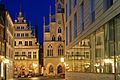
Row of houses at the old market in Dortmund

Hansemann colliery in Mengede

Old Henrichenburg ship lift

Waltrop historical center

Canal bridge over the Stever

Vischering Castle, Ludinghausen
Modern and historical architecture go hand in hand in Münster
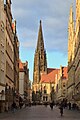
Münster: Prinzipalmarkt with Lambertikirche
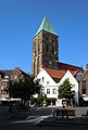
Rheine: City church from the historic market square

The Emswehr in Rheine

Historic town hall Lingen

Kreuzkirche in Lingen

Historic town hall in Meppen

Bascule bridge on the main canal of Papenburg

Fronehaus in Weener
Kaakebogen in Weener

Baroque house Samson in Leer, built in 1643
Empty: "To the balance and the stock market"
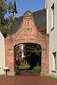
Old port gate Emden

The Gödens house on the Roten Siel in Emden

Schöningh's house in the north

North: Deichmühle, in the background the Frisia-Mühle


.jpg)


- With over half a million inhabitants, Dortmund is the largest city in the Ruhr area , and the range of culture and places of interest is correspondingly large. The city, which emerged from the founding of the Carolingian imperial court , developed from a once important imperial and Hanseatic city to today's industrial metropolis . Like the entire Ruhr area, Dortmund also had to go through the difficult structural change from heavy industry to a modern service metropolis at the end of the 20th century . The landmarks of Dortmund are the Reinoldikirche , the Westfalenhalle , the Dortmunder U and the Florian Tower . (Further information on culture and sights of Dortmund .)
- Waltrop lies between the core zone of the Ruhr area and the rural Münsterland between Dortmund-Ems Canal, Lippe and Datteln-Hamm Canal . In the historical center is the parish church of St. Peter from the 9th / 10th century with a 40 meter high church tower. Around the church there is a picturesque half-timbered ensemble, which also includes the "temple". The house, built around 1576, is considered the oldest half-timbered house in Waltrop. The Henrichenburg ship lift from 1899 can now be viewed as a museum. It belongs to the Westphalian Industrial Museum of the Westphalia-Lippe Regional Association and is part of the Waltrop lock park . This includes all four lock structures that have been built here since 1899, as well as the museum. In addition to models and pictures, part of the museum is a collection of historic ships on a 400-meter-long section of canal that is unique in Europe.
- Datteln is located on the largest canal cross in Europe. This is where the Rhine-Herne Canal , the Dortmund-Ems Canal, the Datteln-Hamm Canal and the Wesel-Datteln Canal as well as the " Alte Fahrt ", a disused arm of the Dortmund-Ems Canal , meet . In the former mining town is the town hall from 1912, around which a tree path with a primeval sequoia leads. It was not until 1941 that this genus was discovered in an inaccessible mountain region in China. The Hermann Grochtmann Museum , in which the history of Datteln is presented, is located near the town hall . The oldest church in the city is St. Amandus Church, which was almost completely destroyed in a bomb attack in May 1945. The Horne Castle with its lovely chapel in the district Horneburg is a little off the bike route.
- The small town of Olfen and its surroundings are shaped by 1000 years of history. Of the former six moated castles, the Sandfort Castle and the ruins of the Rauschenburg House are still preserved today. The Steveraue Olfen are located along the Stever . A renatured meadow landscape and a local recreation area with the Füchtelner mill. Prince-Bishop Otto III. (1301–1306), Count von Rietberg , had the Füchtelner mill built as a state mill. It belonged to the Wasserburg Haus Füchteln. There are several interesting bridge structures along the "Alte Fahrt". The new canal route was built between 1929 and 1937 between Datteln Lüdinghausen. The " Alte Fahrt - Lippe " canal bridge , built in 1895, crosses the Lippe between Datteln and Olfen. The " Schiefe Brücke " leads the "Alte Fahrt" of the Dortmund-Ems Canal over Oststrasse. Today the bridge trough is no longer filled with water and is used as a cycling and hiking trail. Not far from there is the three arch bridges. The historic canal bridge over the Stever led the Dortmund-Ems Canal across the river. Today the Dortmund-Ems Canal Route leads over the bridge and offers a view over the Steverauen. The landmark of Olfen is the parish church of St. Vitus , which can be seen from afar , the fourth church at this point.
- Lüdinghausen, known as the three- castle town, is located on the Stever. The moated castle Lüdinghausen dates from the 12th century . Located in the city center, the former fortifications form the city park. Not far away is Vischering Castle , a water castle that has largely been preserved and still has the character of a fortified castle. The castle Kakesbeck located just north of Ludinghausen at Stever, directly on the bike route. Today the castle is a two-part complex, which consists of a core and a bailey area and is surrounded by an extensive system of ditches filled with water from the Stever river.
- The municipality of Senden is located directly on the Dortmund-Ems Canal. The moated castle of Senden is located close to the canal . The bike route leads directly past it. In the center of the village there is the Bürgerpark, and on the edge of the Venner Moors belonging to Senden , the cycle route continues north.
- The city center of Münster is not affected by the cycle route, but a visit is highly recommended. The city with an eventful history offers a large number of sights. From an architectural point of view, Münster is a city full of contradictions. The perception is shaped by the old town in the area of the Prinzipalmarkt , while the city is predominantly built on in terms of its total area in the style of post-war and post-modernism. The appearance of the city center around the Prinzipalmarkt with its arcade and gabled houses has been almost completely preserved since the 12th century. Since the churches shape the cityscape of Münster very much, Münster was given the name "Nordic Rome" at an early stage. When Fabio Chigi - who later became Pope Alexander VII - stayed in Münster in the middle of the 17th century to negotiate the Peace of Westphalia, he said of the city: “The pointed towers rise up into the clouds, from which everyone can hear Melodic bells ring. ” The two most important churches in Münster are the St. Paulus Cathedral , the first construction of which began in 805, and the Lambertikirche . More information under Culture and sights of Münster .
- The cycle route also leads east of the city of Rheine , along the Dortmund-Ems Canal. The old town of Rheine is well worth a visit. There are several interesting historical buildings there. Magnificent town houses such as the Beckers house, the St. Dionysius parish home, the Beilmannsches house and the Nienkemper house are grouped around the market square. Numerous churches shape the face of the city. The oldest of them is the Catholic Church of St. Dionysius , which is located in the historic city center. The Catholic Church of St. Antonius towers over all other buildings in the city with the highest church tower in the Münsterland. In addition, the Falkenhof Museum , the Museum Kloster Bentlage and the Saline Gottesgabe are worth seeing.
- With 51,000 inhabitants, the city of Lingen is by far the largest city in the Emsland district . The Lingen market square is considered the best parlor in town. Here, among other things, is the historic town hall from 1555, which, with its stepped gable from 1663, is the city's landmark. There are numerous gabled houses on the market square and in the adjacent old town. The oldest were rebuilt after the great fire in Lingen in 1548. The Alte Posthalterei is one of them. The oldest town house in the city, dating from 1653, is located at Am Markt 8. There is also a humorous group of figures from the market fountain. To the east of the market square and connected to it by the narrow Clubstrasse is the Universitätsplatz with the seminar building built between 1678 and 1680, the professors' house from 1684/85 and the baroque Evangelical-Lutheran Kreuzkirche. The most beautiful street in Lingen is probably Burgstrasse. From the market square you can first find the Hellmannsche Haus from 1641 with its richly ornamented half-timbered gable and the Catholic Bonifatius Church, built from 1832 . A little further you can find the Palais Danckelmann from 1646, which has housed the district court for centuries; part of the local history museum is located in the associated coach house (servants' house) from the early 18th century.
- In Meppen , the district town of the Emsland, the cycle route runs on the edge of the old town. There you will find the city museum, the residence with the attached grammar school church and the town hall from 1408, today the city's landmark. Worth seeing in Meppen are, among other things, the exhibition center for the archeology of the Emsland , the coupling lock from 1830 on the former Ems-Hase Canal , the Herrenmühle (a water mill from the 16th century) and the Höltingmühle (a Dutch mill from the 17th century).
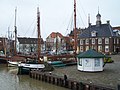
- The city of Papenburg is located east of the cycle route, but can alternatively be visited via the Emsland route without additional kilometers. It is the southernmost seaport in Germany and is known nationwide primarily for the Meyer shipyard . The Ems is dammed once or twice a year with the help of the barrage in Gandersum , so that the Meyer Werft can transfer its ocean-going vessels to the North Sea . Papenburg is a canal town and the longest and oldest fen town in Germany. In addition to the richly furnished neo-Gothic St. Antonius Church with its 88 m high tower, the city has several museums and visitor centers: the Meyer Werft visitor center, the old administrative building with a local museum, the Von Velen plant open-air museum, the Papenburg time memory and that Maritime Museum. The Maritime Museum consists of several historical ships spread across the city.
- The East Frisian town of Weener had a port on the Ems for centuries and was on the left-hand Ems trade route to the south of the Münsterland, which is no longer important today. Warehouses and town houses have remained at the harbor, which was built in 1570. In the old town adjoining the old port is the St. George's Church, built around 1230 as a brick building, as well as many town houses from earlier centuries. Outstanding are the Fronehaus with its renaissance facade and the rococo-style Kaakebogen at the Georgskirche that used to separate the ecclesiastical and secular areas of the Weeneraner market. The Georgskirche has one of the most valuable organs in East Frisia. Also in Weener is the Organeum , a cultural and educational center to which a museum with historical and replica keyboard instruments is attached.
- The East Frisian district town of Leer with its seaport has been shaped by trade for centuries. Due to the good state of preservation of its historic houses, the old town is considered to be the "most valuable" in the region. Four castles, numerous town houses and churches from several centuries can be found in the city. The most famous churches in the city include the Luther Church and the Great Church , the main church of the Evangelical Reformed Church in Germany. The town hall from 1894 is based on the Dutch Renaissance style and forms an ensemble together with the neighboring Historical Scales from 1714 in the style of the Dutch high baroque . The district court from 1720, a former palace, is also in baroque style. The four so-called castles of Leer are the two oldest reinforced stone houses, while the two younger ones are castles. The Harderwykenburg is the oldest and dates from the first half of the 15th century. The Haneburg was laid out from 1621. Of the Evenburg , which was built around 1650, only the outer bailey has been preserved, while the main bailey was converted into a neo-Gothic style castle in 1861 . The Philippsburg is a baroque palace from around 1730.
- Emden is the largest city in East Frisia ; it is located at the mouth of the Ems , on the north bank of the Dollart . The city emerged as a Frisian trading center around the year 800 and has been largely shaped by its seaport to this day. Emden is also known as the birthplace of the comedians Otto Waalkes and Karl Dall , who shaped the proverbial East Frisian joke through their work . In particular, “Otto” made his hometown better known through films and music albums. The city lost a large part of its historical building fabric as a result of heavy bombing during World War II. The best-known structures that have been preserved or rebuilt are the Emden town hall , the old port gate from 1635, the Pelzer houses in the Pelzerstarße in the old town and the Gödens house as the oldest preserved building. There are also three floating structures in the Emder Ratsdelft . The lightship Amrumbank , the rescue cruiser Georg Breusing and the herring logger city of Emden . All three ships are open to the public and can be visited.
- With the city of the north , the North Sea coast and the end of the cycle route is reached. Norden is one of the oldest cities in East Frisia and is located in a region characterized by agriculture and tourism. The ferry port to the North Sea islands of Juist and Norderney is located in the Norddeich district , which has been officially the " North Sea Spa " since 2010 . The Ludgerikirche , the largest church in East Frisia, is located on the northern edge of the market square . In addition to many cultural and art historical treasures, the Ludgeri Church houses the second largest preserved Arp Schnitger organ in Germany and the largest organ in East Frisia. The Mennonite Church in the north on the market square is one of the city's notable buildings. It is a former patrician house built in 1662 . The large market square in the center of the north has trees, some of which are more than 250 years old, and is surrounded by numerous older buildings. Around the market square are the so-called Dree Süsters (Three Sisters), three gable-top brick buildings of the Renaissance that were built around 1600. Other historical buildings are the old town hall, the Vossenhus (fox house) and the old post office. There are other buildings worth seeing in Osterstrasse, not far from the market; the most impressive building on the street is the Schöningh House, a richly decorated Renaissance building from 1576. There are still three historic windmills in the city area: the Deichmühle , the Frisia-Mühle and the Westgaster Mühle.
Literature and Sources
- Wikipedia and websites of the towns along the route. Accessed April 2013.
- Bicycle touring map Rad-Route Dortmund-Ems-Kanal, 1: 50.000, PublicPress Verlag, ISBN 3-89920-167-1 .
- bikeline bike tour book EmsRadweg. From the sources to the mouth. With Dortmund-Ems Canal , 1: 50,000. 1st edition. Verlag Esterbauer, 2000, ISBN 978-3-85000-041-3 .
- Dortmund-Ems Canal - from the Ruhr area to the North Sea coast. Compact spiral. Bielefelder Verlag, 2009, ISBN 978-3-87073-461-9 .
Web links
- Dortmund-Ems Canal Route in Emsland
- Tourist association Freren-Lengerich-Spelle
- Dortmund-Ems Canal Route in pictures
- Presentation of the Dortmund-Ems Canal Route at nordwestreisemagazin.de
- GPS track of the DEK route
- Dortmund-Ems Canal Route ( Memento from June 30, 2013 in the web archive archive.today ), on adfc-tourenportal.de
Individual evidence
- ↑ muensterland-tourismus.de: Dortmund-Ems Canal Route