
Bruchertseifen
| coat of arms | Germany map | |
|---|---|---|

|
Coordinates: 50 ° 45 ' N , 7 ° 43' E |
|
| Basic data | ||
| State : | Rhineland-Palatinate | |
| County : | Altenkirchen (Westerwald) | |
| Association municipality : | Hamm (victory) | |
| Height : | 275 m above sea level NHN | |
| Area : | 2.89 km 2 | |
| Residents: | 775 (Dec. 31, 2019) | |
| Population density : | 268 inhabitants per km 2 | |
| Postal code : | 57539 | |
| Area code : | 02682 | |
| License plate : | AK | |
| Community key : | 07 1 32 014 | |
| LOCODE : | DE UFN | |
| Community structure: | 5 districts | |
| Association administration address: | Lindenallee 2 57577 Hamm (Sieg) |
|
| Website : | ||
| Local Mayor : | Axel Mast | |
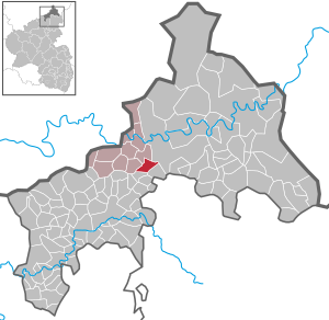
| Location of the local community Bruchertseifen in the district of Altenkirchen (Westerwald) | ||
  |
||

Bruchertseifen is a municipality in the Altenkirchen (Westerwald) district in Rhineland-Palatinate . It belongs to the community of Hamm (Sieg) .
Community structure
In addition to the eponymous place, the districts Haderschen, Hofacker, Langenbach and Neuschlade belong to Bruchertseifen.
history
Bruchertseifen was first mentioned in a document in 1610 . Until the middle of the 17th century Bruchertseifen, Haderschen, Hofacker and Langenbach belonged to the county of Sayn . After the introduction of the Reformation in the county of Sayn, the inhabitants were first Lutheran and later reformed .
After the division of the County of Sayn in the 17th century, the villages of Bruchertseifen, Haderschen and Langenbach became part of the County of Sayn-Hachenburg . Together with Haderschen and Langenbach, Bruchertseifen formed a "Sende" (administrative unit) that belonged to the Hamm parish . The place Haderschen was on the border between Sayn-Hachenburg and Sayn-Altenkirchen , around 1787 there were five houses in the Hachenburg part and one house in the Altenkirch part. The current district of Hofacker also belonged to Sayn-Altenkirchen and until 1955 to the municipality of Racksen .
The county of Sayn-Hachenburg fell to the princes of Nassau-Weilburg by inheritance in 1799 . In connection with the formation of the Rhine Confederation , Bruchertseifen and its current districts came to the newly established Duchy of Nassau in 1806 . Under the Nassau administration, the places belonged to the Schöneberg office and the Ehrenbreitstein administrative district .
Due to the agreements made at the Congress of Vienna (1815), the Nassau area was ceded to the Kingdom of Prussia . Under the Prussian administration went in 1816 the parish Hamm in the newly formed Mayor's Hamm on which the Altenkirchen district in Koblenz and from 1822 at the Rhine province was assigned.
The district of Langenbach was divided until 1974, to the right of the Langenbach the village belonged to the municipality of Helmeroth , to the left of the Bach it has always belonged to Bruchertseifen.
- Statistics on population development
The development of the population of Bruchertseifen in relation to today's municipality; the values from 1871 to 1987 are based on censuses:
|
|
|
politics
Municipal council
The local council in Bruchertseifen consists of twelve council members, who were elected in the local elections on May 26, 2019 in a majority vote, and the honorary local mayor as chairman.
mayor
The local mayor of Bruchertseifen is Axel Mast. In the direct election on May 26, 2019, there were no applicants. In this case, the municipal code provides for an election by the municipal council, which took place on August 13, 2019 during the constituent meeting. Mast is the successor to Jan Burbach, who held the office for ten years.
traffic
The federal highway 256 leads through Bruchertseifen .
Personalities
- Arnold Morkramer (* 1929), sculptor
- Margret Wintermantel (* 1947), President of the German Academic Exchange Service (DAAD) (2012–2020)
- Klaus-Peter Wolf (* 1954), writer, screenwriter
- Thomas Enders (* 1958), head of the European aircraft manufacturer Airbus (2012-2019)
See also
literature
- Paul Hild: The community of Bruchertseifen. In: Hans Günther Mack (Hrsg.): Heimatbuch für Hamm (Sieg) and the district of Hamm (Sieg). Altenkirchen 1956, pp. 166–168.
- Klaus Thiesbonenkamp: Historical highlights through Bruchertseifen. In: Heimat-Jahrbuch des Kreis Altenkirchen 58. 2015, pp. 70–73.
- Klaus Thiesbonenkamp: School conditions in Bruchertseifen. In: Heimat-Jahrbuch des Kreis Altenkirchen 59. 2016, pp. 182–191.
Web links
Individual evidence
- ↑ a b State Statistical Office of Rhineland-Palatinate - population status 2019, districts, municipalities, association communities ( help on this ).
- ↑ State Statistical Office Rhineland-Palatinate (ed.): Official directory of the municipalities and parts of the municipality. Status: January 2019 [ Version 2020 is available. ] . S. 14 (PDF; 3 MB).
- ↑ Daniel Schneider: The development of denominations in the county of Sayn in plan. In: Heimat-Jahrbuch des Kreis Altenkirchen 58. 2015, pp. 74–80.
- ^ Hellmuth Gensicke: Landesgeschichte des Westerwaldes. 3. Edition. Historical Commission for Nassau, Wiesbaden 1999, p. 440, ISBN 3-922244-80-7 .
- ^ Wilhelm Fabricius : Explanations of the historical atlas of the Rhine province. The map from 1789. Volume 2. Bonn 1898, p. 368.
- ^ Johann Ludwig Klüber: Acts of the Vienna Congress - in the years 1814 and 1815. Volumes 21–24, 1836, p. 157 ( Google Books ).
- ↑ Local community of Bruchertseifen on the website of the Hamm (Sieg) association. .
- ↑ State Statistical Office Rhineland-Palatinate: My village, my city. Retrieved February 17, 2020 .
- ^ The Regional Returning Officer Rhineland-Palatinate: City Council Election 2019 Bruchertseifen. Retrieved November 15, 2019 .
- ↑ The Regional Returning Officer Rhineland-Palatinate: direct elections 2019. Retrieved on November 15, 2019 (see Hamm (Sieg), Verbandsgemeinde, fourth row of results).
- ^ Local community Bruchertseifen: Minutes of the constituent meeting of the local community council. (PDF) August 13, 2019, accessed November 2, 2019 .
- ↑ Klaus-Peter Wolf impressed with “Ostfriesenmoor”. In: AK-Kurier. August 27, 2013, accessed February 18, 2020 .

Almersbach | Alsdorf | Altenkirchen (Westerwald) (city, seat of the district administration) | Bachenberg | Berod near Hachenburg | Berzhausen | Betzdorf (city) | Birch honey meal | Birch bump | Birnbach | Bitches | Brachbach | Breitscheidt | Bruchertseifen | Bürdenbach | Burglahr | Busenhausen | Daaden (city) | That | Dickendorf | Eichelhardt | Oak trees | Elves | Elkenroth | Emmerzhausen | Ersfeld | Etzbach | Eulenberg | Fensdorf | Fiersbach | Flammersfeld | Floodlight | Forest | Forstmehren | Friedewald | Friesenhagen | Fürthen | Gebhardshain | Gieleroth | Giershausen | Grünebach | Güllesheim | Hamm (victory) | Harbach | Hasselbach | Helmenzen | Helmeroth | Hemmelzen | Herdorf (city) | Haylofts | Hilgenroth | Hirz-Maulsbach | Horhausen (Westerwald) | Hövels | Idelberg | Ingelbach | Isert | Katzwinkel (victory) | Chew | Kescheid | Kettenhausen | Churchib | Churches (victory) (city) | Kraam | Krunkel | Malberg | Mammelzen | Mauden | More | Michelbach (Westerwald) | Mittelhof | Molzhain | Mudersbach | Nauroth | Neitersen | Niederdreisbach | Niederfischbach | Niederirsen | Niedersteinebach | Nisterberg | Obererbach (Westerwald) | Oberirsen | Oberlahr | Obernau | Obersteinebach | Oberwambach | Oils | Orfgen | Peterslahr | Pleckhausen | Splendor | Racksen | Reiferscheid | Rescuers | Rosenheim (District of Altenkirchen) | Roth | Rott | Scheuerfeld | Schöneberg | Stokes | Schutzbach | Seelbach (Westerwald) | Seelbach near Hamm (victory) | Soaps | Selbach (victory) | Sörth | Steinebach / Victory | Steineroth | Stürzelbach | Volkerzen | Wallmenroth | Walterschen | Weitefeld | Werkhausen | Weyerbusch | Willroth | Knowledge (city) | Wölmersen | Goat grove