
Bad Camberg
| coat of arms | Germany map | |
|---|---|---|

|
Coordinates: 50 ° 18 ' N , 8 ° 16' E |
|
| Basic data | ||
| State : | Hesse | |
| Administrative region : | to water | |
| County : | Limburg-Weilburg | |
| Height : | 197 m above sea level NHN | |
| Area : | 54.63 km 2 | |
| Residents: | 14,221 (Dec. 31, 2019) | |
| Population density : | 260 inhabitants per km 2 | |
| Postal code : | 65520 | |
| Primaries : | 06434, 06483 | |
| License plate : | LM, WEL | |
| Community key : | 06 5 33 003 | |
| LOCODE : | DE BDC | |
| City structure: | 6 districts | |
City administration address : |
Am Amthof 15 65520 Bad Camberg |
|
| Website : | ||
| Mayor : | Jens-Peter Vogel ( SPD ) | |
| Location of the city of Bad Camberg in the Limburg-Weilburg district | ||
  |
||

With around 14,800 inhabitants, Bad Camberg is the second largest city in the west of the central Hessian district of Limburg-Weilburg . It is located in the Hintertaunus , about 30 km north of the state capital Wiesbaden and 20 km south of the district town of Limburg an der Lahn . Bad Camberg is the central location of the Goldener Grund with a good infrastructure and a sub-center with partial function of a medium-sized center on the edge of the Rhine-Main area . The recognized Kneipp spa is the oldest of its kind in Hesse and the third oldest in Germany. The symbol of the city is the Kreuzkapelle .
geography
Geographical location

Bad Camberg - the southernmost municipality of the Limburg-Weilburg district and the entire Gießen administrative district - is located in the Hintertaunus in the Goldener Grund , which connects the Idsteiner Senke with the Limburg basin and divides the Hintertaunus into an eastern and a western half; The city is also centrally located in this north-south direction. Bad Camberg is located 18 kilometers south-east of Limburg an der Lahn (the kilometers are the routes on the roads), 30 kilometers north of Wiesbaden, 45 km south-west of Wetzlar , 48 km north-west of Frankfurt am Main (59 kilometers on the motorway), 62 Kilometers southwest of Giessen and 68 kilometers east of Koblenz .
Heights

The city is at an altitude of around 200 meters. One of the highest elevations in the Limburg-Weilburg district, the Kuhbett (526 m), is located in the district of the core town of Bad Camberg on the border with the community of Weilrod in the Hochtaunus district . An unnamed hill with a height of around 320 meters, on which the Way of the Cross leads to the Chapel of the Cross, connects directly to the city center in the northeast . The highest elevation in the district of the core city is on its eastern edge with a height of around 490 meters. The core city district is structured in a trough-shaped manner, with the mostly weakly incised valley of the Emsbach in the middle. On the western edge, the area with the stone head rises up to 317 meters.
Expansion of the urban area
The Goldener Grund, through which the Emsbach flows, extends in the western part of the city from south to north through Bad Camberg. The districts of Würges , Bad Camberg, Erbach and Oberselters are located here (from south to north). The eastern urban area, with the two districts of Schwickershausen and Dombach, is much less populated and located higher up. From the Goldener Grund, the land rises on both sides to the Taunus. The district of the core city extends long in the south-west-northeast.
Neighboring communities
The surrounding communities of Bad Camberg are (clockwise, starting in the north): Selters (Limburg-Weilburg district), Weilrod (Hochtaunus district), Waldems ( Rheingau-Taunus district ), Idstein (Rheingau-Taunus district), Hünstetten (Rheingau -Taunus-circle), Hünfelden (Limburg-Weilburg). Apart from the municipalities belonging to the Limburg-Weilburg district, all of Bad Camberg's neighboring municipalities are not part of the Gießen administrative district , but rather the Darmstadt administrative district .
geology
The geology of the entire urban area is determined in the two thirds of the area east of the Emsbach by slate and slate- containing greywacke , west of the Emsbach by loess deposits . In between, a quartz gravel band stretches to the east, parallel to the Emsbach.
The geology of the Bad Camberger core city district is determined in the mountain ranges in the east by greywacke with a high proportion of slate. The core city itself is enclosed in the east by a quartz gravel deposit, to the west of the city there is a layer of loess . The western edge of the district is in turn formed by a field of greywack slate in the south, iron-shed slate in the northwest and the Steinkopf, a quartzite deposit, in between .
City structure
The city consists of six districts; Population as of June 2011:
| district |
population |
Total area in km² |
of which forest in km² |
in % |
Population density (inhabitants per km²) |
|---|---|---|---|---|---|
| Bad Camberg (city center) | 7,060 | 19.91 | 10.89 | 54.7 | 346.7 |
| Erbach | 2,710 | 10.66 | 4.91 | 46.0 | 263.0 |
| Choke | 2,661 | 13.82 | 6.27 | 45.4 | 184.1 |
| Oberselters | 1.108 | 4.22 | 0.84 | 19.9 | 278.0 |
| Schwickershausen | 579 | 2.77 | 0.66 | 23.8 | 211.2 |
| Dombach | 392 | 3.26 | 1.38 | 42.3 | 105.5 |
| Bad Camberg (total) | 14,510 | 54.64 | 24.95 | 45.7 | 263.5 |

Parish Church of St. Georg in Schwickershausen

Old town hall in Dombach, eaves side
Parish Church of St. Ferrutius in Würges, side view

Old mayor's house in Erbach

Church of St. Antonius in Oberselters

Kreuzkapelle Bad Camberg from the inside


history
Early history


The band ceramics culture from the Neolithic Age (5000–3000 BC), which got its name from its pottery, are the oldest finds in the Camberg area. While most of the groups at that time were dependent on hunting and gathering, the band ceramists were already producing their food through agriculture (including emmer and einkorn) and animal husbandry . The houses were mostly 20 to 25 meters long and five to seven meters wide. Irregular pits are always encountered within the settlements, and their excavation was used to build the houses. They were repeatedly filled with waste such as charcoal, animal bones, ashes, stones and ceramic shards. In some built-up areas of the core city, the streets have cut through several garbage pits.
The second settlement period is from 600 BC. Until 500 BC Chr. Made out. The barrows along the L 3031 towards Usingen are assigned to this time.
First mentioned (1000)
On February 6, 1000, Emperor Otto III. the monastery of Burtscheid the royal court of Cagenberg , whereby a clear reference to the county is missing. Cagenberg probably means mountain of the Cago, whereby Cago would be an abbreviation of the name Garganhardt, a name that appeared several times in the family of the Konradines , the lords of the Lahngau in the 10th century. The name of the farm suggests that it was a comparatively young settlement, possibly from the 9th or 10th century. Some surrounding places such as Selters, Erbach, Würges and Dauborn are already guaranteed to be in the 8th century. However, it cannot be ruled out that there was also a precursor settlement for Cagenberg.
Seligenstadt Monastery, County Diez (1053-1388), town charter (1281)
According to a certificate from Emperor Heinrich II from 1018, Cagenberg was in the Lahngau . In the same year, the farm changed from Burtscheid's property to that of the Seligenstadt monastery . From the name Cagenberg Cainburg , Camburg , Kamberg and Camberg developed and according to other information Cagenberc (1018), Kamberch (1156), Kahberg (1194), Kamberc (1197) and later Kaynburg . In 1053 the settlement fell to the Counts of Diez , who took over large parts of their property after the Conradinians died out. The Counts of Diez were to rule the city until 1388. Bad Camberg was the southernmost larger settlement in the Diezer area and was specially fortified against the neighboring county of Idstein. Camberg Castle was located near today's Amthof . On August 27, 1281, King Rudolf I , obtained from Count Gerhard IV., Granted city rights based on the Frankfurt legal system, which were renewed in 1300 and 1336. However, it was only a clearing and not a complete elevation to the city. Camberg thus had the status of a minority town . It was not until 1356/57, and with confirmation from 1365, that Camberg received full city rights. With this legal act at the latest, the construction of a city wall began , which was probably completed around 1380.
In addition to the sovereigns, numerous other landlords had property in the city, including the Limburg Georgsstift as one of the most important.
A district court in Camberg is mentioned for the first time in 1311 and lasted until 1800. By 1548 at the latest, the Camberg court was also responsible for blood jurisdiction . In the 18th century at the latest, however, the importance of the court seems to have declined considerably.
After the Epiphany in 1357, legend has it that all Cambergers were drunk and slept when Walsdorf robber barons tried to rob the city. The city wall was still under construction at the time, so only the bridge had to be crossed. However, magpies lived there (in dialect Atzeln ) who noticed the robbery attempt and shouted the alarm. This awakened the Cambergers, thwarted the attack and put the Walsdorfers to flight. Even today, the Atzel is therefore regarded as the city's “unofficial bird of arms”.
Nassau-Dillenburg, Katzenelnbogen, Lords of Eppstein, Landgraviate of Hesse (1388–1479)
Since the Counts of Diez died out in 1388, Adolf von Nassau-Dillenburg inherited the city. From 1403 the city was pledged to Katzenelnbogen . During this time Camberg was occupied by Frankfurt am Main , which was in feud with Katzenelnbogen , but was recaptured shortly afterwards. After the death of Adolf von Nassau in 1420, a condominium was built between the county of Nassau-Dillenburg and the Lords of Eppstein , who in 1428 even received three quarters of the city. In 1452/54 the Counts von Katzenelnbogen bought a quarter of the city of Eppstein and another eighth of Dillenburg, the latter being sold back in 1481. In the meantime, all owners pledged shares to other nobles or Kurtrier for a shorter period of time . After the Katzenelnbogen family died out in 1479, the Landgraviate of Hesse raised claims to the city's former Katzenelnbog quarter.
In 1421 the forest of Camberg, Würges and Erbach belonged to a market cooperative , in which first the Counts of Diez and then those of Nassau took the dominant position.
The main church in Camberg was consecrated to St. Peter in the High Middle Ages. The Limburger Georgsstift was the patron of the Camberg parish . The earliest mention of a priest by name was in 1156 a Gernot. At that time, the Camberg parish already comprised today's districts as well as the now desolate village of Alsdorf bei Würges and Walsdorf . The parish belonged to the Archdiocese of Mainz until 1235 and from that point on to the Archdiocese of Trier , which later also held some of the sovereignty of the state.
Trier and Nassau (1535–1794)

In 1508 Eppstein fell to the Counts of Königstein . When the Counts of Königstein died out in 1535, the Electorate of Trier occupied Camberg and received half of the city on a permanent basis. This achieved a certain stabilization of the power relations. Until around 1800, Camberg belonged to Kurtrier and Nassau to half, whereby the Nassau part changed several times between different lines of the widely ramified house. In 1557 the Hessian Quarter was finally slammed into Nassau-Dillenburg in the Frankfurt Treaty. From 1607 to 1628, a quarter that was Dillenburg before and after belonged to Nassau-Hadamar . In 1652, the half of Dillenburg went to Nassau-Diez and in 1743 to Oranien-Nassau .

In the early modern period, Camberg largely had the character of an arable town . Two mayors are mentioned for the first time in 1404, a city council in 1458 and a town hall in 1481. The town hall must have fallen into disrepair around 1720. A new building was planned, but never implemented. Presumably, as early as the 17th century, the bailiffs of the sovereigns largely took over the tasks of mayors and municipal self-government fell into disuse. There was a council from 1454 at the latest, but it never got beyond a minor local importance. Wool processing and pottery were carried out in the town on a somewhat larger scale. At least two fulling mills were temporarily available. In 1581 there were seven guilds in the city, each of which was joined by several trades due to its small size.
The city fortifications with a mighty wall and several towers were maintained until the early 18th century, although sections that were completely collapsed are mentioned for 1660. By 1750 the facilities had largely fallen into disrepair and no longer served a military function.
From 1535 to 1794 the Camberg office was under the joint administration of the House of Nassau and von Kurtrier. In addition to all of today's districts, it also included Haintchen and later Eisenbach and Hasselbach . For each of the two gentlemen a bailiff looked after the interests in Camberg. Due to the frequent change of rule between the various Nassau lines, the electorate officials succeeded in developing an important position. With the Amthof, today's town hall, they also had a dominant building complex in the city. The Electoral Trier official dignity was mostly in the hands of one of the long-established noble families von Heiden, von Hohenfeld or von Schütz-Holzhausen. For 1651 it is proven that the Electoral Trier authorities Limburg and Villmar were administered from Camberg . A teacher in the city was first mentioned in 1625.
The earliest information about the Camberg population comes from 1632 and gives 80 citizens. For 1700 there are 98 households, 104 handicraftsmen and five widows. In 1790 the total number of inhabitants was given as 1003 for the first time. In 1788, 70.2 percent of the property was in bourgeois hands, 26.2 percent in noble hands and 3.6 percent in clergy.
Jewish residents are first established with certainty for 1576. In 1662 five Jewish families with 32 people were counted. There was a synagogue by 1756 at the latest.
Witch trials in Camberg
Witch trials in Camberg were carried out especially in the years 1629–1631, 1643–1644 and 1659–1660. 14 women and one man were charged, eight women were executed and one died in custody. The remaining accused were released, often after torture. Barbara Ordeneck was the victim of the last known execution.
End of multiple rule, Prussia (from 1866)
_1881.jpg)
In 1802 Nassau-Weilburg took over the Kurtrierische half of the city. In 1806, the Duchy of Nassau was formed from Orange-Nassau, Nassau-Usingen and Nassau-Weilburg , thus ending the multiple rule over the city. At the beginning of the 19th century, the Camberg office was dissolved and initially affiliated to the Kirberg office (but with its seat in Camberg), and from 1816 to the Idstein office. After the annexation of the Duchy of Nassau by Prussia in the German War in 1866, Nassau fell to Prussia , where it belonged to the province of Hesse-Nassau , the administrative district of Wiesbaden and the Untertaunuskreis . In 1886 Camberg became part of the new Limburg district . The Camberg court was also robbed of a large part of its area of jurisdiction and its powers in 1808.
In 1810, Hugo Freiherr von Schütz zu Holzhausen, who was born deaf himself, taught "deaf and dumb" for the first time in rooms of the Amthof. This made him one of the pioneers in this field in Germany. In the following years the lessons became a permanent school facility and in 1820 the "Duke of Nassau Deaf-Mute Institute". Until 1875 it was housed in an outbuilding of Guttenberger Hof in the old town. A separate building for the school was erected in 1894 on a site on Frankfurter Strasse donated by the city of Camberg. It is still there today under the name Freiherr-von-Schütz-Schule . After 1970 the school took over the neighboring former district court and in 2001 the building was expanded.
In 1820 a classical school building was built next to the church and expanded in 1894. In 1873 a higher boys' school started teaching and in 1890 a higher school for girls.
In 1861 Moritz Lieber founded a hospital, the Lieber'sche Hospital, on Gisbert-Lieber-Straße. It was dissolved in 1959. Today the Freiherr von Schütz School uses the building.
The German Revolution of 1848/1849 led in Bad Camberg, as in the entire north-west of the Duchy, above all to the formation of political Catholicism. The local Piusverein , chaired by Moritz Lieber , was one of the largest in the entire duchy with six branches in February 1850.
Industrial area, health resort (1927), Bad (1981)
In the 20th century, the city expanded mainly to the west, in the direction of the train station. From the 1920s, the construction of an industrial park west of the railway line began.
Camberg has been a Kneipp health resort since 1927. In 1937 the title Recognized Spa was awarded. Camberg has been a state-approved Kneipp spa since 1977 . Camberg was given the designation "Bad" in 1981 on the occasion of the 700th anniversary of the city charter. In 1973 the Hohenfeld Clinics were completed.
time of the nationalsocialism
Establishment of the Nazi power structures by the Lawaczeck family
The brothers Ernst Lawaczeck and Paul Lawaczeck had already made an active contribution to the "movement" in the Limburg district in 1928. Both in Bad Camberg and in the Limburg district they played a central role. In the process, Ernst Lawaczeck and his brother Paul, who was twelve years older than him, had a systematic division of their roles. Ernst Lawaczeck, later mayor of Camberg, was the local group leader of the NSDAP there . In the years 1939–1941 he held the position of district chairman of the NSDÄB in Limburg and the position of head of the public health department in the NSDAP's district staff. In Camberg itself, Lawaczeck concentrated on the persecution of political opponents, which was carried out systematically and with the support of the SS in the course of the so-called "seizure of power". In order to consolidate the power structures of the NSDAP, Lawaczeck operated, as he put it in a letter to the district leader (1936), the "fight against political Catholicism". As mayor, Ernst Lawaczeck was instrumental in the plundering of the Jews, but also of the Jewish religious community, which he carried out for the benefit of regional Nazi officials and the community finances. Paul Lawaczeck was mainly active on the national political level. In 1924 Paul Lawaczeck was a member of the district council for the Limburg district. In 1929 a member of the NSDAP in the provincial parliament. From 1934 district deputy and from 1929 to 1933 district leader of the NSDAP in Limburg. In 1936 Paul Lawaczeck became deputy district administrator of the Limburg district. Paul Lawaczeck's wife, Anna (Ännie) geb. van Gelder (1886–1976) supported the regime as head of the Nazi women's group.
Persecution of Jewish citizens and political opponents
On April 1, 1933, the last democratically elected mayor, Johann Pipberger, was driven out of office as part of the coordination . The application to leave the office was justified with “permanent incapacity”. On April 10, the National Socialist Ernst Lawaczeck was elected as acting mayor and introduced into his office. The actual election of the mayor, which was carried out unanimously, took place on October 10, 1933. At the meeting of the united corporations of the city of Camberg, the magistrate and the city council, the urgent motion was made to make Hitler and Hindenburg honorary citizens of the city of Camberg. This proposal was accepted unanimously. The naming and renaming of the following streets was also unanimously approved:
- Strackgasse in Adolf-Hitler-Strasse
- Street from the bathhouse to the Protestant church in Hermann-Göring-Straße
- Allee from Haus Schorn to Chaussee after the Tenne in Hindenburg-Allee
- City park in Hindenburg complex
- Neugasse in Peter-Gemeinder-Straße
- Green place in Horst-Wessel-Platz
The first victim of the Nazi terror in Camberg was the mayor Johann Pipberger, who was in office from 1905 to March 1933, who was badly mistreated by system-compliant violent criminals on August 2, 1933 and thrown down the stairs of his house, where he was seriously injured. Similar acts of violence were carried out against other citizens, for example against carpenter Emmel, cattle dealer Steinberg, postmaster Schütz, Landesbank director Hardeck, family Löwenberg, Berthold and Moritz Landau, Hermann Steinberg, Heinrich Schneider, Walter Bachenheimer, the farmer Peter Schmitt and his son Philipp.
The synagogue in Schmiedgasse was torn down during the Reichspogromnacht . Subsequently, Jewish private and business houses were looted and their residents abused by the mob marauding in the streets. After many Camberg Jews had emigrated in the early 1930s, the pogrom night marked the beginning of the final annihilation of the Jewish citizens. A few weeks later, all the gravestones in the Jewish cemeteries were knocked over. In 1937, 69 Jews were still living in Camberg, 27 of whom managed to emigrate in time. In 1942 alone, eight Jewish residents were abducted and murdered. After the war there were no more Jews living in Camberg. Few of them managed to flee abroad; the textile merchant Hermann May first emigrated to Amsterdam, from where he was later deported and murdered. The family of the metal goods dealer Moritz May fled to Frankfurt am Main on the night of the pogrom, which, however, like most of the Camberg Jews, whose fate has not yet been researched, could not save them from deportation and murder. In archives, especially in the Hessisches Hauptstaatsarchiv Wiesbaden, there is a largely not yet viewed and evaluated inventory of foreign exchange and compensation files on the deported and murdered Camberg Jews who, like the memorial book - victims of the persecution of Jews under the Nazi tyranny 1933–1945 , conclusions about the fate of almost every individual.
Stage power plant as a prototype of Nazi economic and energy policy
Franz Lawaczeck , who has been professor of hydraulics at Gdansk University of Applied Sciences since 1934 , brother of Nazi mayor Ernst Lawaczeck and, like his brothers Paul and Ernst, has been a member of the NSDAP since the mid-1920s, designed the Camberg power station he built in accordance with Nazi economic ideology . Franz Lawaczeck had already described this hydropower plant, which was supposed to supply the rural population with cheap electricity, in 1932, i.e. before the so-called seizure of power , in the party's own Nazi publication series National Socialist Library , edited by Gottfried Feder . The aim of the project, which was intended as a prototype for power generation in the Nazi state, should be the systematic elimination of “Jewish big business” from the energy industry. The communal energy industry was intended to send a signal against the “usury of money and goods”, the “highwaymen” and “speculators ... mostly Jews”. The essentially anti-liberalist orientation of the economic view represented by Franz Lawaczeck in the concept of the multi-stage power plant is based on a primarily "Jewish" defined, capitalist private economy that uses the electricity market to the detriment of the "German-blooded" craftsmen and farmers for their own profit. With the economic model of the multi-stage power plant, the Nazi ideologist Lawaczeck is promoting an economy that corresponds to the “racially conditioned ideal” according to Gottfried Feder's idea and which should give the “Germanic peoples” the economic ability “through their union, finally, the permanent wall against indigenous races to erect and to push this wall permanently closed towards the east. ”Despite multiple political protection, u. a. by the Gauleiter Jakob Sprenger , Lawaczeck's project failed because it did not prove to be economical. The ruins of the Camberg multi-stage power plant are still on site. In regional historiography, Franz Lawaczeck is honored as an "inventor engineer", omitting his involvement in National Socialism.
National Socialist "welfare" in the building of the Freiherr-von-Schütz School
In today's Freiherr-von-Schütz-Schule , the then “deaf-and-dumb institution”, the Camberger house and farm school was housed since 1937 on the initiative of the department head Fritz Bernotat . After the pupils originally taught there, according to the Nazi doctrine of " life unworthy of life ", which was directed against the handicapped , had been pushed to Frankfurt, i.e. the resources to be distributed in the institutional welfare system had been re-weighted in the spirit of National Socialism, Bernotat set up one under management the BDM 's educational institution for female welfare pupils. In this, they should be prepared for their role as housewives and mothers. In addition to instruction in housekeeping, horticulture and child care, ideological instruction was given there in accordance with Nazi ideology. Due to the increasingly scarce labor force in times of war, welfare children from the Camberg house and farm school were preferably placed with local Nazi functionaries and party comrades (Mayor Lawaczeck, Weyrich construction business, department store Ide and Burdy and the Urban family) as house maids.
From the organizational in the Verein für Volkspflege e. V. embedded home and agricultural work school, welfare children were taken to the Hadamar killing center in the context of Action T4 and murdered there. Ruth Pappenheimer , who was murdered on the Idsteiner Kalmenhof in October 1944, was assigned to the Camberg house and farm work school over the course of several years.
Deployments during the Second World War
During the Second World War and especially in 1944, several units of the Wehrmacht were stationed in the city. As part of the advance of the Western Allies in the conquest of the German Reich, the first US soldiers of the 3rd Battalion of the 385th Infantry Regiment reached Camberg on March 29, 1945. There they encountered stationed SS units , which were eventually supported by artillery of the 76th Infantry Regiment US Infantry Division were fought. The fighting in the city continued all night. On March 30, 1945, Camberg was liberated by US soldiers at 8 a.m. After the end of the war, the city was assigned to the US occupation zone and later part of Hesse .
Changing administrative districts, Limburg-Weilburg district
The city belonged to the administrative district of Wiesbaden . With its dissolution in 1968 Camberg became part of the administrative district of Darmstadt and in 1981 Gießen . In 1974 the city became part of the Limburg-Weilburg district that was created by merging .
1957 began the construction of a new school center, today's Taunus school. In 1964 the secondary school started operating there.
Incorporations
In the 1970s there were territorial reforms across Germany, including the territorial reform in Hesse . On August 13, 1970, the communal working group Goldener Grund came into force. Its aim was to unite the congregations of the Golden Ground through a voluntary association. Ten communities, today's six Bad Camberger districts as well as the Selterser districts of Niederselters , Eisenbach and Haintchen as well as Hasselbach , now part of Weilrod , signed this. On December 11, 1969, the Hessian interior minister announced that proposals for reorganization would be drawn up for all municipalities in the state. This provided for Camberg, Würges, Erbach, Schwickershausen and Dombach to be united to form the town of Camberg, while Oberselters was to form the municipality of Selters (Taunus) with Niederselters, Eisenbach and Haintchen . The municipal council of Dombach was of the opinion that the independence of the village would be maintained until there was a forced union on the part of the state. The local council of Würges also feared that construction projects in their village would be postponed and that Camberg would become the cultural center of the city.
In January 1971, the Limburg district again proposed the small solution. The current districts except Oberselters should form the new city of Camberg. However, it was also considered that Oberselters , Hasselbach , Walsdorf and Steinfischbach could belong to Camberg. The local council of Oberselters spoke out in favor of Camberg in the event of a merger, while Hasselbach oriented itself towards Weilrod . Most of the populations of Walsdorf and Steinfischbach were for Idstein and Waldems, so that the amalgamation planned at the time coincides with today's city limits. The communities of Camberg, Erbach, Schwickershausen and Oberselters supported this amalgamation, Dombach wanted to wait and Würges did not want to voluntarily amalgamate them. The state of Hesse named December 31, 1971 as the last possible date for a voluntary union.
On November 9, 1971, a border change agreement was signed between the five present-day Camberg districts without Würges and between Eisenbach and Haintchen to establish the new town of Camberg. However, this contract was not recognized by the Hessian state government; this called for Eisenbach, Haintchen and Oberselters to be part of the community of Niederselters, and proposed the union of Camberg with Erbach, Schwickershausen and Dombach. The communities sued the Hessian Administrative Court in order to enforce the incorporation of Oberselters, Eisenbach and Haintchen on January 1, 1972. The government was required to allow the merger, but it appealed. There were no more oral hearings before the Administrative Court in Kassel, and the appeal proceedings were closed in May 1975.
On July 1, 1974, Camberg, Würges, Erbach, Schwickershausen and Dombach were forcibly united to form the city of Camberg by state law. The Oberselters community joined the association.
population
On December 31, 2010, 14,078 people lived in Bad Camberg, which corresponds to a population density of 258 inhabitants per square kilometer. In 2005 there were 14,391 inhabitants. The population density is thus slightly above the national average and below the state average. The proportion of foreigners in 2005 was 7.0 percent.
Population development
The population of the individual districts has developed as follows since 1910:
| district | 1910 | 1970 | 1974 | 1987 | 1998 | 2004 | 2005 |
|---|---|---|---|---|---|---|---|
| Bad Camberg (city center) | 2,575 | 4,956 | 5,247 | 5,586 | 6,515 | 6,800 | 6,903 |
| Erbach | 1,114 | 2.111 | 2,257 | 2,468 | 2,869 | 2,805 | 2,804 |
| Choke | 926 | 2,101 | 2,185 | 2.147 | 2,453 | 2,530 | 2,545 |
| Oberselters | 587 | 1,017 | 1.002 | 1,221 | 1,178 | 1,173 | |
| Schwickershausen | 332 | 465 | 492 | 536 | 553 | 585 | 585 |
| Dombach | 238 | 225 | 259 | 307 | 366 | 385 | 382 |
| Bad Camberg (total) | 5,772 | 11,457 | 12,045 | 13,977 | 14,281 | 14,391 |
The population of the city as a whole and the proportion of foreigners in Bad Camberg has developed as follows since 1993:
| year | population | Foreigners | Proportion of foreigners in percent |
|---|---|---|---|
| Dec 1993 | 13,483 | 1070 | 7.9 |
| Dec 1994 | 13,576 | 1122 | 8.3 |
| Dec 1995 | 13,701 | 1222 | 8.9 |
| Dec 1996 | 13,781 | 1235 | 9.0 |
| Dec 1997 | 13,884 | 1264 | 9.1 |
| Dec 1998 | 13,835 | 1105 | 8.0 |
| Dec 1999 | 13,983 | 1082 | 7.7 |
| Dec 2000 | 13,982 | 1050 | 7.5 |
| Dec 2001 | 13,885 | 1017 | 7.3 |
| Dec 2002 | 13,916 | 1017 | 7.3 |
| Dec 2004 | 14,263 | circa 1040 | 7.3 |
| Dec 2005 | 14,391 | 1013 | 7.0 |
| Dec 2006 | 14,378 | approx. 1080 | 7.5 |
| Dec 2007 | 14,281 | circa 1040 | 7.3 |
| Dec 2008 | 14,184 | circa 1020 | 7.2 |
| Dec 2009 | 14,182 | approx. 1050 | 7.4 |
| Dec 2010 | 14,078 |

Religions
In contrast to the eastern, southern and western neighboring communities, Bad Camberg and its districts have always been Catholic. Because it belonged to the Electorate of Trier until 1803, the Camberg office at that time was almost exclusively Catholic. Currently there are around 3600 Catholics living in the core city, which corresponds to a share of 52%. There are six Catholic parishes that are united in the pastoral area of Bad Camberg: St. Peter and Paul in Bad Camberg, St. Mauritius in Erbach, St. Ferrutius in Würges, St. Antonius in Oberselters, St. Georg in Schwickershausen and St. Wendelin in Dombach.
The Evangelical Martinskirche was inaugurated on September 8, 1897, before the Protestant citizens had to use the churches in Niederselters and Walsdorf . The catchment area of the Bad Camberger Church is the core town, Erbach, Würges, Dombach and Schwickershausen, while the Protestant Christians from Oberselters visit the Christ Church in Niederselters. Bad Camberg and Selters have merged to form a parish.
The Free Evangelical Congregation (FeG) Bad Camberg has existed in Bad Camberg since 2007 . It is one of over 450 independent local congregations in Germany and is organized in the Federation of Free Evangelical Congregations (BFeG). Since the congregation does not have its own rooms, the services take place in the auditorium of the Freiherr-von-Schütz-Schule in Bad Camberg.
From the 17th century until 1942 there was a Jewish community in Camberg. No Jews lived in the districts, but the Jewish residents of Walsdorf , Steinfischbach (from 1907) and Eisenbach belonged to the Camberg community. The synagogue was badly damaged in the November pogroms in 1938 . The number of Jews living in Camberg decreased from 69 to 19 people in the years 1933 to 1939 due to emigration, flight and departure. In 1942 the last members of the Jewish community living in Camberg were deported to Frankfurt and murdered.
politics

mayor
According to the Hessian municipal constitution, the mayor is chairman of the magistrate , which in the city of Bad Camberg includes twelve voluntary councilors in addition to the mayor . Jens Peter Vogel was elected mayor on April 26, 2017. His predecessors were:
- 2005 to 2017 Wolfgang Erk (SPD) taking office was delayed because the runoff election was repeated
- 1992 to 2004 Gerhard Reitz (SPD)
- 1974 to 1992 Ernst Enzmann (CDU) He was mayor of the city even before the municipal territorial reform
City Council
The local elections on March 6, 2016 produced the following results, compared to previous local elections:
| Parties and constituencies |
% 2016 |
Seats 2016 |
% 2011 |
Seats 2011 |
% 2006 |
Seats 2006 |
% 2001 |
Seats 2001 |
||
|---|---|---|---|---|---|---|---|---|---|---|
| CDU | Christian Democratic Union of Germany | 47.1 | 17th | 44.0 | 16 | 47.1 | 17th | 47.9 | 18th | |
| SPD | Social Democratic Party of Germany | 39.8 | 15th | 40.0 | 15th | 42.8 | 16 | 40.3 | 15th | |
| Green | Alliance 90 / The Greens | 13.2 | 5 | 14.6 | 5 | 7.0 | 3 | 8.4 | 3 | |
| left | The left | - | - | 1.4 | 1 | - | - | - | - | |
| FDP | Free Democratic Party | - | - | - | - | 3.0 | 1 | 3.4 | 1 | |
| total | 100.0 | 37 | 100.0 | 37 | 100.0 | 37 | 100.0 | 37 | ||
| Voter turnout in% | 51.4 | 47.6 | 48.2 | 54.5 | ||||||
Federal and state politics
In federal elections, the city has been part of the Rheingau-Taunus-Limburg constituency since 1949 , which has been represented in Berlin since 1998 by the CDU MP Klaus-Peter Willsch . Bad Camberg is part of the Limburg-Weilburg II state electoral district , in which Andreas Hofmeister, who lives in the city , was directly elected as the successor to long-time MP Karlheinz Weimar (both CDU) in the 2013 election.
In a supra-regional comparison, the CDU and FDP in Bad Camberg achieved over-, SPD and Die Linke sub-regional votes. The Bundestag, Landtag and European elections since 2004 have produced the following results in the city:
| Political party | EW '04 | BTW '05 | LTW '08 | LTW '09 | EW '09 | BTW '09 | LTW '13 | BTW '13 |
|---|---|---|---|---|---|---|---|---|
| CDU | 51.6 | 41.7 | 47.9 | 48.3 | 47.2 | 39.3 | 47.0 | 47.2 |
| SPD | 22.1 | 31.3 | 29.1 | 17.3 | 18.5 | 20.8 | 25.6 | 23.7 |
| FDP | 5.9 | 11.7 | 9.2 | 16.2 | 11.4 | 17.3 | 4.6 | 5.5 |
| Green | 10.9 | 8.4 | 6.8 | 10.7 | 12.0 | 10.7 | 9.1 | 8.0 |
| left | 1.2 | 3.9 | 3.6 | 3.8 | 2.8 | 6.8 | 4.2 | 5.1 |
| AfD | - | - | - | - | - | - | 4.3 | 6.6 |
| Others | 8.3 | 3.0 | 3.4 | 3.7 | 8.1 | 5.1 | 5.2 | 3.9 |
coat of arms
|
|
Blazon : "In red a tinned silver tower with a blue tent roof and closed golden gate, above the base covered with a red square, in which, one above the other, two looking, striding, blue armored, golden lions." |
| Justification of the coat of arms: The coat of arms of the city shows the Obertorturm, the eastern tower of the city, with its gate. The golden lions on a red background come from the coat of arms of Grafschaft Diez, to which Bad Camberg belonged. |
Town twinning
- since 1987: Chambray-lès-Tours , France

- since 1991: Bad Sulza , Thuringia

Bad Camberg has been sibling with the French town of Chambray-lès-Tours since October 3, 1987. In May 2012, the 25th anniversary of this town twinning was celebrated in Chambray. In the course of this long time, close friendships have developed between the residents of the two cities. Large partnership meetings take place at least every five years, in which up to 200 citizens from both the German and French sides take part.
On January 9, 1991, the "Agreement on friendship between Bad Sulza and Bad Camberg" was signed. Over the years there have always been occasions to visit each other, especially the mayors and the top of the administration maintain a regular exchange.
Culture and sights
Buildings


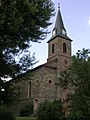
The Kreuzkapelle is the symbol of the city. Today's chapel was built in 1725 on a mountain east of the city and can be seen from afar.
In the old town there is still a large number of half-timbered houses, some of which have very elaborate ornamentation. Most of the houses were built between the 15th and 18th centuries. Many of these houses are grouped around the market square, which was a trading post on Hohen Strasse from Cologne to Frankfurt.
The most popular sight of the city is the half-timbered group of the Amthof. It extends over a front length of 155 meters, making it one of the largest half-timbered buildings in Hesse. The representative building was erected in 1605 on the foundation walls of the previous building. In the following years, up to 1669, it was expanded and the originally three individual courtyards merged into one ensemble. The Amthof was the seat and residential building of the senior officials of the Electorate of Camberg. With the dissolution of the office in 1815, it lost its importance. In 1942 the city acquired the Amthof. In 1989 she had it completely renovated. Today it is the seat of the city administration.
Another important half-timbered building is the old local pharmacy , the foundation walls of which date from 1330 and which was rebuilt in 1492 as the Burgmannenhaus of the von Hattstein family . The house has housed a pharmacy since 1663. Today's Guttenberger Hof was first mentioned in 1336 as the seat of the von Hattstein family. It was rebuilt in its current form in 1526. In 1767 the plant changed into the possession of the von Guttenberg family and in 1820 into civil ownership. The Guttenberger Hof is currently (October 2007) being renovated.
Only remnants of the former city fortifications have survived. With the Obertorturm (32 meters high, built around 1380) and the Untertorturm (built from 1365 to 1380), two of the former 13 towers are still standing.
Adjacent to the Amthof is the Obertorturm, also a symbol of the city, which also appears in the city coat of arms. The Hohenfeld Chapel is right next to it . The chapel is furnished with numerous furnishings from different centuries, including plates with grave inscriptions from the von Metternich and Hohenfeld families , von Schütz zu Holzhausen , von Bechtolsheim and Spies von Büllesheim, who are important for the city . Today the Obertorturm and Hohenfeld Chapel serve as the city and tower museum.
The Untertorturm is popularly known as the "Leaning Tower of Bad Camberg". The tower owes its name to a slope of 1.44 meters at a height of 21 meters. There were once three gates in a row at its base. Its old hood was destroyed in the final stages of World War II in 1945.
The Kreuzkapelle, the Church of St. Peter and Paul, the Upper and Lower Gate Tower, the city wall, the Amthof and the Hohenfeld Chapel have received the protection status of the Hague Convention in the event of war.
Catholic Church of St. Peter and Paul
The Catholic Church of St. Peter and Paul is in the northwest of the old town. For the first time a St. Peter church in Camberg was mentioned in a document from 1156 . The oldest part of today's church is the tower built in 1580. After the nave fell apart in the 18th century, a new church had to be built. It was built by the Dillenburg building inspector Johann Friedrich Sckell in plait style and is one of the few examples of this type of construction in the region. The Elector Auxiliary Bishop Johannes Maria von Herbain consecrated the church on July 15, 1781 in honor of the Apostles Peter and Paul.
Evangelical Martinskirche
The Protestant St. Martin's Church and the rectory were built in 1896–1897 under Pastor Ernst. In order to receive state subsidies for the construction costs, the community had to coordinate a lengthy, complex process with the state building administration on the one hand and with the church institutions on the other. The finally approved design came from government and building officer Hermann Eggert (then lecturer advice for church the Prussian Ministry of public works in Berlin), while the experienced already in the Protestant religious building Herborn architect Ludwig Hofmann under the supervision of the Wiesbaden district government , the construction management exercised. For the inauguration, Empress Auguste Viktoria gave the congregation an altar Bible.
Spa gardens
The spa gardens in Bad Camberg were laid out in the 18th century by the Schütz von Holzhausen family. The park is located directly at the Obertor on the edge of the old town. In addition to a water treading pool , the stock of old trees and the water features, the park also offers a mini golf course and several tennis courts . In 2002 an approx. 800 m² show herb garden was laid out in the spa gardens.
Regular events
Autumn market
In Bad Camberg, the Camberger Kerb (high German: Kirmes = Kirchweih ) has taken place every year since 1781 at the same time as the autumn market . The time is always the second weekend in October, although the actual parish fair is celebrated on June 29th (Peter and Paul). Since 2004 it has been traditionally held in the marquee in the Pfortenwiesen (old sports field). The Camberger Curb is organized by the Camberger Curb e. V. and the current notch year.
VW veterans meeting
The VW veterans' meeting of the Lottermann family, which is known worldwide in the VW scene , has been a tradition in Bad Camberg since 1979. The oldest and rarest vehicles arrive every four years. The last beetle meeting took place in 2019.
Sports
The most successful football club is the RSV Würges from the district of the same name , which was a long-time member of the sometimes third-class football Hessen league and took part in the DFB Cup twice. SV Bad Camberg 1921, which specializes in soccer and handball, is based in the city center. There are other sports clubs in the districts.
Economy and Infrastructure
The facilities typical for a sub-center such as banks, general practitioners, pharmacies, primary schools, the city administration, shops for basic supplies etc. are available in Bad Camberg, as are the facilities typical for medium-sized centers such as secondary schools or a swimming pool. As a result, the city is considered a sub-center with partial function of a medium-sized center.
Companies
The OberSelters fountain operation is located in the Oberselters district . Mineral water is bottled here under various brand names such as OberSelters Original, OberSelters Catharinen-Quelle, Nassauer Land and Bad Camberger Taunusquelle. There are also lemonade and apple spritzer from the brands OberSelters and Mabella.
Furthermore, the Europe-wide known company HACA Ladern, the company Weber Bürstensysteme and the Serviceware SE have their headquarters in Bad Camberg.
Health resort

The range of treatments includes the MEDIAN Hohenfeld clinics (psychosomatic medicine and psychotherapy: 253 beds, orthopedics and osteology: 120 beds) as rehabilitation clinics and a neurological rehabilitation clinic (150 beds), several spa homes, the MEDIAN therapy center at the spa park (practice for physiotherapy, wellness and Kneipp) as well as several water treading facilities. In 2005, Bad Camberg recorded 176,663 overnight stays by spa guests. The average length of stay was 8.6 days.
traffic
Bad Camberg is located on the A 3 , which goes back to one of the oldest trade routes in the world, and on the parallel high-speed route Cologne – Rhine / Main . Numerous residents commute to work in the Rhine-Main area from the city center and the districts .
High street - highway
As early as the Bronze Age , which occurred in Central Europe around 1750 BC. Begins, the Hohe Straße , which led from Constantinople to Brussels , led past the watershed of the Ems and Wörs brooks . The feeder from the city to Hohen Strasse was the Limburger Weg (first mentioned in 1355 as Lympurger Weg ), which was renamed Taunusstrasse in 1959 and Lahnstrasse in 1979 due to the risk of confusion with Limburger Strasse . Hohe Straße was no longer used in the 18th century.
In 1934, the city of Camberg joined the company for the preparation of the Frankfurt-Cologne motorway. This Reichsautobahn (today A 3 or E 35 ) was built between 1937 and 1939. The course of the Golden Ground roughly coincides with that of the old Hohe Strasse.
Bad Camberg is connected to the motorway by the junction of the same name. Initially not included in the planning, the exit was built to allow the places in the Goldener Grund to participate in the development of traffic and economy. In 1954, the Bad Camberg-Ost service station and service station was opened on the motorway in the direction of Cologne , followed by Bad Camberg-West in the direction of Frankfurt a year later .
Via Publica - federal road 8

In the 12th century, roads were gradually built in the valleys. Above all, the growth in the trade in goods contributed to this, but also the growing danger on the High Street . This created the Emstalstrasse, a section of the old Via Publica (Brussels – Prague).
In 1768 Kurtrier began with the expansion of the country roads and the road from Limburg to the state border between Würges and Walsdorf, which was completed in 1780. The superstructure of the Chaussee, which led past the Untertorturm west of the city limits at that time, was completely destroyed again after two to three years by the heavy traffic. In 1786 the citizenry applied for the road from Erbach to the Obertorturm, then through the city through to the Untertorturm and then on to Würges. However, the request was denied. Due to the Kurtrier road construction regulations of 1753, the citizens of the Camberg district had to do road duty in spring and autumn . The electoral court chamber provided the labor and material costs for the bridge construction, while the municipalities and the office had to provide the materials. Only after the revolution of 1848 were all compulsory labor abolished.
At the beginning of the 20th century, this street developed into Fernverkehrsstraße 8 (FVS 8), later Reichsstraße 8 (R 8) and today's Bundesstraße 8 ; it currently runs through Erbach, Bad Camberg and Würges and passes Oberselters. A bypass road has been planned for the first three locations for over thirty years and has now (as of 2014) reached the planning approval stage.
bus and train
The Bad Camberg station is located on the Main-Lahn Railway between Frankfurt and Eschhofen in Limburg an 49.3 kilometer (from Frankfurt (Main) Hauptbahnhof counted). The line was opened in stages and reached Camberg from the Niederselters train station in 1876. It was later expanded so that today the entire Limburg – Bad Camberg – Niedernhausen – Frankfurt or Wiesbaden section is used continuously. The RMV lines RE 20 and RB 22 lead to Frankfurt, and the RB 21 to Wiesbaden via the Ländchesbahn branching off in Niedernhausen .
Since December 2004 a city bus has been offered in Bad Camberg on two lines LM-31 and LM-32. Both lines run on separate routes from the train station to the city center and then to Erbach or Würges .
media
Dominant regional newspaper in Bad Camberg is the since 1948 in Limburg an der Lahn appearing Nassauische Neue Presse - a header page of the Frankfurter Neue Presse . Furthermore, the Lokalanzeiger (Wednesdays and Saturdays), the Camberger Anzeiger (Thursdays), Bad Cambergerleben (Fridays) and the LZ on Sundays (Sundays) are distributed free of charge to all households. The first three advertising papers mainly report on the city and the surrounding area, while for the LZ appearing in Taunusstein on Sunday, Bad Camberg is on the edge of the distribution area.
education
There are three primary schools in Bad Camberg: the Regenbogenschule in Erbach, the Atzelschule in Bad Camberg and the Würges primary school in the Würges district. The Taunusschule Bad Camberg is a comprehensive school with upper secondary school , at which secondary and secondary school qualifications and the Abitur can be completed. The Freiherr-von-Schütz-Schule , which dates back to 1810, is a deaf school (today with an attached boarding school) and covers seven Hessian city and rural districts. The regional adult education center Limburg-Weilburg e. V. operates a branch in Bad Camberg.
Kindergartens
There are seven kindergartens in Bad Camberg. In addition to the three run by the city (two in Bad Camberg and one in Würges), there are Catholic kindergartens in the city center, in Erbach and Oberselters. In addition, there has been a forest kindergarten near the Kreuzkapelle since 2007 .
Fire brigades
- Bad Camberg volunteer fire brigade , founded in 1898 (with youth fire brigade since September 14, 1991 )
- Dombach volunteer fire brigade, founded in 1975 (with youth fire brigade since December 22, 1995)
- Voluntary fire brigade Erbach, founded in 1934 (with youth fire brigade since March 4, 1972)
- Oberselters volunteer fire brigade, founded in 1934 (since June 4, 1974 with youth fire brigade)
- Schwickershausen volunteer fire brigade, founded in 1957 (with youth fire brigade since November 10, 1973)
- Würges volunteer fire brigade, founded in 1905 (since January 2, 1970 with youth fire brigade and since May 28, 2010 with children's fire brigade )
German Red Cross, local association Bad Camberg
The DRK local association Bad Camberg was founded twice, 1932-1945 and 1958 until today. The members of the local association are committed to the people in Bad Camberg. The local association is active in the social field, in the medical service as well as in humanitarian aid and disaster control. The structure currently has 518 members.
Personalities
Honorary citizen
- Caspar Hofmann (born October 29, 1899 in Camberg; † November 2, 1987), Catholic priest, senior director of studies
Known citizens
- Barbara Ordeneck (* around 1600, † 1659), victim of the Camberg witch hunt
- Achatius von Hohenfeld (* 1610 at Aistersheim Castle (Upper Austria); † December 3, 1672 in Camberg), Nassau-Diezer military and civil servant, electoral Trier Oberamtmann in the Camberg office and Reichspfennigmeister
- Gisbert Lieber (* 1759; † 1843), Privy Councilor of the Count of Sternberg-Manderscheid
- Ferdinand Christoph Schütz von Holzhausen (born October 24, 1773 in Camberg; † January 22, 1847 there), canon and member of the Nassau state parliament
- Moritz Lieber (* 1790 at Blankenheim Castle; † December 29, 1860), son of Gisbert Lieber, founder of the hospital, was a German lawyer, politician, publicist, author, translator and tea merchant. He is considered the "father" of the German Center Party
- Ernst Lieber (born November 16, 1838 in Camberg; † March 31, 1902 in Camberg), son of Moritz Lieber, central politician, member of the Prussian Landtag and German Reichstag, co-founder and temporarily president of the German Catholic Congress
- Johann Theodor Zöller (* 1684; † 1758), cath. Pastor, later converted to the Calvinist faith
- Marie Mallarmé (* 1835 in Camberg; † 1910), b. Christina Maria Gerhard, wife of the French poet Stéphane Mallarmé
- Paul Lawaczeck (born December 22, 1878 in Ottweiler, † November 26, 1942 in Rottenburg), Nazi functionary and deputy district administrator during the National Socialist era
- Ernst Lawaczeck (born February 18, 1890 in Bad Camberg; † October 12, 1950 ibid), NS mayor, local group leader of the NSDAP and chairman of the National Socialist Medical Association in the Limburg district
- Franz Lawaczeck (born July 3, 1880 in Camberg; January 20, 1969 in Pöcking am Starnberger See ), engineer, Nazi economic theorist and builder of the Camberg multi-stage power plant
- Heinz Lawaczeck (born August 19, 1891 in Camberg; † September 21, 1963 in Hillersee), doctor, internist, associate professor in Gießen, medical officer in Hanover, chief physician of the field hospital, from 1940 head internist in the Wehrmacht High Command
- Barbara Klimmek (born August 25, 1942 in Berlin), teacher, special educator and author
- Anna Elisabeth Koch-Burdi, mother of the painter Joseph Anton Koch
- Peter Cathrein (born June 8, 1829 - † August 17, 1911), mayor
- Franz Alfred Muth (born June 13, 1839 in Hadamar ; † November 3, 1890 in Dombach im Taunus ), priest
- Christian Meurer (born January 20, 1856 in Camberg, † March 6, 1935 in Würzburg), canon and constitutional lawyer
- Johann Pipberger (* 1876 in Dehrn / Lahn ; † August 26, 1945 in Bonn), mayor from 1905 to 1933
- Heinrich Held (born June 6, 1868 in Erbach, † August 4, 1938 in Regensburg) Bavarian politician and Prime Minister
- Franz Carl Friedrich von Hohenfeld (born November 8, 1696 in Bad Camberg, † September 8, 1757 in Worms), dean of the cathedral in Worms and governor of the prince-bishop
- Kuno Damian Freiherr von Schütz-Holzhausen (born February 15, 1825 in Camberg, † June 23, 1883 in Bensheim), settler in Peru
- Ernst Meyer-Camberg (born November 12, 1904 in Würzburg; † November 13, 1985 in Munich), physician and student historian, founder of a spa clinic for naturopathy in Bad Camberg
- Karlheinz Weimar (born January 30, 1950 in Kirberg), former Hessian finance minister, currently lives in Erbach
- Markus Mörl (born August 27, 1959 in Camberg), German pop singer
- Jocco Abendroth (born August 28, 1953 in Camberg; † June 15, 2007 in Frankfurt am Main), German singer / songwriter ("Hearts must burn")
- Vüqar Aslanov (* 1964 in Geranboj), writer and journalist, lived in Bad Camberg from 2000 to 2011; he wrote several of his works in Bad Camberg.
- Sarah Diehl (* 1978 in Bad Camberg-Erbach), journalist, author, cultural scientist and documentary filmmaker
- Ayse Asar (* 1975), State Secretary in the Hessian Ministry for Science and Art, lives in Bad Camberg
literature
- Randolf Fügen: Highlights in Central Hesse. The 100 attractions in the region. Wartberg-Verlag, Gudensberg-Gleichen 2003, ISBN 3-8313-1044-0 , p. 8.
- Magistrate of the City of Camberg (Ed.): Camberg. 700 years of city rights. Contributions to local history . Camberger Verlag Lange, Bad Camberg 1981, ISBN 3-87460-045-9 .
- Erich Müller, Egon Wagenknecht (Red.): Oberselters and his history (= Bad Camberger Archivschriften. No. 6, ZDB -ID 24776-5 ). Bad Camberg City Archives, Bad Camberg 1993.
- Michael Wettengel : The democratic association system in the countryside in the Duchy of Nassau . In: Nassau Annals . tape 98 . Wiesbaden 1987, p. 205-227 .
- Search for literature on Bad Camberg in the SPK digital portal of the Prussian Cultural Heritage Foundation
- Search for Bad Camberg in the archive portal-D of the German Digital Library
- Literature about Bad Camberg in the Hessian Bibliography
Web links
|
Further content in the sister projects of Wikipedia:
|
||
|
|
Commons | - multimedia content |
|
|
Wikisource | - Sources and full texts |
|
|
Wikinews | - News |
|
|
Wikivoyage | - Travel Guide |
- Official website of the city of Bad Camberg
- Bad Camberg, Limburg-Weilburg district. Historical local dictionary for Hessen. In: Landesgeschichtliches Informationssystem Hessen (LAGIS).
- Link catalog on Bad Camberg at curlie.org (formerly DMOZ )
Individual evidence
- ↑ Hessian State Statistical Office: Population status on December 31, 2019 (districts and urban districts as well as municipalities, population figures based on the 2011 census) ( help ).
- ↑ Data-numbers-facts worth knowing about Bad Camberg ( Memento from November 29, 2010 in the Internet Archive )
- ↑ Camberg 700 Years of City Rights, p. 19
- ↑ Certificate of donation 1000
- ↑ Camberg 700 Years of City Rights, p. 25
- ↑ Architectural and cultural monuments in the Limburg district
- ↑ Oberselters and his story, p. 98
- ^ Witches trials / witch persecution Bad Camberg and the names of the victims (PDF; 93 kB), accessed on May 9, 2016.
- ^ Rudolf Wolf: witch trials in Camberg. In: Camberg, 700 years of city rights. Editor: Magistrat der Stadt Bad Camberg, published by Camberger Verlag Ulrich Lange, 1991, p. 55
- ↑ STAC XV Box 8/3.
- ↑ Cambergs Chronik 1918–1945 by Albert Schorn, self-published by the author, pp. 64–67
- ↑ Cambergs Chronik 1918–1945 by Albert Schorn, self-published by the author, pp. 76–79
- ↑ Cambergs Chronik 1918–1945 by Albert Schorn, self-published by the author, pp. 81–84. Camberg, 700 years of city rights, Camberger Verlag Ulrich Lange, 1981
- ↑ Cambergs Chronik 1918–1945 by Albert Schorn, self-published by the author, p. 84
- ↑ Camberg 700 years of city rights , Camberger Verlag Ulrich Lange, 1981, p. 238
- ↑ Renkhoff, Otto. Nassauische Biografie (1992) No. 2502 p. 452.
- ↑ House friend for the golden reason. (February 24, 1934) Reprinted in: Camberg. National Socialism in a small town. Materials. Published by the Hessian Institute for Teacher Training Branch Limburg. P. 41.
- ↑ Technology and Economy in the Third Reich. A job creation program. Franz Lawaczeck: In: National Socialist Library, issue 38. Ed. Gottfried Feder (1932)
- ↑ The Camberger Stufenkraftwerk: Anti-Semitism cast in concrete, on vtaktuell, accessed on December 18, 2013
- ↑ Lawaczeck (1932) p. 28 ff.
- ↑ Lawaczeck (1932) p. 90.
- ↑ Lawaczeck (1932) p. 91.
- ↑ 1000 years of life in Camberg Ed. Magistrat der Stadt Bad Camberg (2000).
- ↑ Camberg. 700 years of city rights. Contributions to local history. Ed. Magistrate of the City of Bad Camberg (1981)
- ↑ Sandner, Peter. Administration of the murder of the sick. The Nassau District Association under National Socialism. (2004) p. 210 ff.
- ↑ HHStaWI. Dept. 403/1499.
- ↑ HHStaWI Dept. 403/1499
- ↑ StAC XXI / 15
- ↑ HHStaWI Abt. 461 No. 32061
- ^ "Violent resistance, many prisoners" , in: Nassauische Neue Presse, May 9, 2015, accessed on February 27, 2018
- ^ Bad Camberg 700 years of city rights, pp. 288–290
- ↑ Law on the reorganization of the Limburg district and the Oberlahn district. (GVBl. II 330-25) of March 12, 1974 . In: The Hessian Minister of the Interior (ed.): Law and Ordinance Gazette for the State of Hesse . 1974 No. 5 , p. 101 , § 9 ( online at the information system of the Hessian state parliament [PDF; 809 kB ]).
- ^ Federal Statistical Office (ed.): Historical municipality directory for the Federal Republic of Germany. Name, border and key number changes in municipalities, counties and administrative districts from May 27, 1970 to December 31, 1982 . W. Kohlhammer GmbH, Stuttgart / Mainz 1983, ISBN 3-17-003263-1 , p. 369 .
- ^ Up to 2002: State Statistical Office, from 2004: Update of the population figures
- ^ Community directory
- ↑ The portal to the golden reason
- ↑ a b update
- ↑ to 2002: State Statistical Office, from 2004: updating of the population figures
- ↑ "Guide to Municipal Data" from 2003 ( Memento of November 14, 2011 in the Internet Archive )
- ↑ a b website “Kath. Parish of St. Peter and Paul Bad Camberg ”at the Diocese of Limburg
- ↑ Evangelical Church Community Bad Camberg and Niederselters
- ↑ Free Evangelical Community of Bad Camberg
- ^ FeG Bad Camberg
- ^ Alemannia Judaica
- ^ Hessian State Statistical Office: direct elections in Bad Camberg
- ↑ Frankfurter Neue Presse of April 26, 2016: Mayor election: Mayor Erk (SPD) no longer runs, term of office runs until April 25, 2017, accessed on September 17, 2016
- ^ Result of the municipal election on March 6, 2016. Hessian State Statistical Office, accessed in April 2016 .
- ^ Hessian State Statistical Office: Result of the municipal elections on March 27, 2011
- ^ Hessian State Statistical Office: Result of the municipal elections on March 26, 2006
- ↑ ( Page no longer available , search in web archives: Hessenschau: Bundestag election 2009 )
- ↑ State election 2009 (PDF; 6 kB)
- ↑ European elections 2009
- ↑ State election 2013
- ↑ Bundestag election 2013
- ↑ Highlights in Central Hesse. P. 8
- ↑ On the seventieth birthday of Hermann Eggert. In: Deutsche Bauzeitung , Volume 48, 1914, No. 1 (from January 3, 1914), p. 10.
- ^ Friedhelm Gerecke: Historicism, Art Nouveau, Heimatstil in Hesse, in the Rhineland and in the Westerwald. The life's work of the architect and monument conservator Ludwig Hofmann. Petersberg, Michael Imhof Verlag 2010. ISBN 978-3-86568-458-5 , pp. 74 f.
- ↑ Camberg. 700 years of city rights. P. 215.
- ↑ 10th International Bad Camberger WV-Veteraen-Treffen ( Memento from July 24, 2015 in the Internet Archive ), accessed on July 24, 2015
- ↑ RSV Würges
- ^ SV Bad Camberg
- ↑ website of Oberselters Mineralbrunnen Vertriebs GmbH
- ↑ HACA ladders
- ↑ Brush systems Weber
- ↑ About Serviceware
- ↑ Camberg 700 Years of City Rights, pp. 70/71
- ↑ Camberg 700 Years of City Rights, pp. 71/72
- ^ B8 bypass (information provided by the City of Bad Camberg, accessed on August 20, 2014)
- ^ Newspapers in Bad Camberg , accessed on December 15, 2011
- ↑ Freiherr vom Schütz School
- ^ VHS Limburg-Weilburg

Bad Camberg | Beselich | Breaking | Dornburg | Elbe Valley | Elz | Hadamar | Hünfelden | Limburg a. d. Lahn | Löhnberg | Mengerskirchen | Merenberg | Runkel | Selters (Taunus) | Villmar | Waldbrunn (Westerwald) | Weilburg | Weilmünster | Weinbach