
Trittenheim
| coat of arms | Germany map | |
|---|---|---|

|
Coordinates: 49 ° 50 ' N , 6 ° 54' E |
|
| Basic data | ||
| State : | Rhineland-Palatinate | |
| County : | Trier-Saarburg | |
| Association municipality : | Schweich on the Roman Wine Route | |
| Height : | 110 m above sea level NHN | |
| Area : | 10.1 km 2 | |
| Residents: | 1049 (Dec. 31, 2019) | |
| Population density : | 104 inhabitants per km 2 | |
| Postal code : | 54349 | |
| Area code : | 06507 | |
| License plate : | TR, SAB | |
| Community key : | 07 2 35 207 | |
| LOCODE : | DE THE | |
| Association administration address: | Brückenstrasse 26 54338 Schweich |
|
| Website : | ||
| Local Mayor : | Franz-Josef Bollig | |
| Location of the local community Trittenheim in the district of Trier-Saarburg | ||
  |
||


Trittenheim is a municipality on the Middle Moselle in the Trier-Saarburg district in Rhineland-Palatinate . It belongs to the Verbandsgemeinde Schweich on the Roman Wine Route .
geography
Trittenheim is on the flat slope of a headland ( sliding slope ), which is formed by a narrow loop of the Moselle. Upstream is the wine village of Klüsserath on the left bank of the river, the wine village of Leiwen on the right bank of the Moselle , and downstream the wine village of Neumagen-Dhron on the right bank of the Moselle.
The Breitwiesermühle and Im Dhrönchen residential areas also belong to Trittenheim .
Closest cities
- Schweich approx. 18 km
- Bernkastel-Kues approx. 25 km
- Trier approx. 30 km, closest regional center
- Wittlich approx. 30 km
- National border with the Grand Duchy of Luxembourg approx. 40 km
- Kaiserslautern approx. 110 km
- Koblenz approx. 120 km
history
Originating from a Franconian settlement, Trittenheim was first mentioned in a document in 893 in the Prümer Urbar and was for a long time an Electoral Trier area. A mention can also be found in a document from Pope Eugene III. from 1148, in which the Abbey of St. Eucharius was awarded a homestead and the church along with the associated tithe rights in Trittenheim. From 1794 Trittenheim was under French rule, in 1815 the place was assigned to the Kingdom of Prussia at the Congress of Vienna .
Trittenheim and Klüsserath formed the Trittenheim mayor's office, which became part of the Klüsserath office in 1934 .
In the 1970s, Trittenheim became part of the then newly created community of Neumagen-Dhron in the Bernkastel-Wittlich district .
Change to the Verbandsgemeinde Schweich
Due to the planned restructuring of the association communities in Rhineland-Palatinate, the Trittenheim citizens decided in March 2010 with over 90% to join the association community Schweich on the Roman Wine Route and thus to move to the district of Trier-Saarburg . The municipal council followed the request and unanimously approved the vote.
On September 14, 2011, the Rhineland-Palatinate state government approved the merger plans, whereby the municipality on January 1, 2012 from the community of Neumagen-Dhron to be dissolved , which belonged to the district of Bernkastel-Wittlich , to the community of Schweich on the Roman Wine Route and thus in could change the district of Trier-Saarburg .
Population development
The development of the population of Trittenheim has been steadily declining since 1961. The values from 1871 to 1987 are based on censuses.
|
|
politics
Municipal council
The municipal council in Trittenheim consists of 16 council members, who were elected in a personalized proportional representation in the local elections on May 26, 2019 , and the honorary local mayor as chairman.
mayor
The current local mayor is Franz-Josef Bollig.
coat of arms
The coat of arms shows a golden abbot's staff . It stands for Johannes Trithemius from Trittenheim , who was abbot of the Sponheim monastery in the Bad Kreuznach district in the 15th century . The red bar cross on silver is the coat of arms of the Electorate of Trier , the silver T stands for Trittenheim.
Attractions
Religious landmarks

- Parish Church of St. Clemens : late baroque church with early classical elements
- Laurentiuskapelle : Located in the vineyards (extended in 1583)
- Plague crosses : seven-part wayside shrines
- Way of the Cross : 14 stations to the Laurentius Chapel
Other sights
- Towers
- Hinkelstein "Eselstratt" on the Galigsberg ( ⊙ ): Discovered on March 16, 2002 on the Galgenberg ( Galigsberg ) in the immediate vicinity of the intersection of the district boundaries of Klüsserath , Trittenheim and Köwerich . Height: 155 cm, width: 110 cm, thickness: 40 cm
- Late antique sarcophagi
- Statue of Johannes Trithemius
- Jewish Cemetery
- Old Moselle train station
- Connection to the Moselsteig hiking trail (from Hinkelstein via Trittenheim, Neumagen and Piesport to Minheim )
- Connection to the Römersteig hiking trail
- Fährfels
- Stefan Andres Monument
- Old bridgehead with bridge tollhouse
- Wine trail
- Zummethöhe viewpoint: Panoramic view of the Moselle loop
- Lookout pulpit in the Trittenheimer Apotheke vineyard
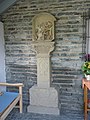
Wayside shrine "Simon of Cyrene helps carry the cross" (1654)

Wayside shrine "Christ before Pilate" (1657)

Wayside shrine "Jesus dies on the cross" (1654)

Wayside shrine "Flagellation" (1654)

Wayside shrine "Christ on the Mount of Olives" (1654)

Wayside shrine "Coronation of Thorns" (1654)


.JPG)
_Spielesstra%C3%9Fe_16_Trittenheim.JPG)
Vineyards
- Altars
- pharmacy
- Ladder
- Rock head
Major location: Michelsberg
economy
Trittenheim is significantly shaped by viticulture and with 236 hectares of vineyards after Piesport , Zell , Leiwen , Konz , Neumagen-Dhron , Mehring and Bernkastel-Kues, the eighth largest wine-growing community on the Moselle . Traditionally, Riesling is mainly grown. The most famous vineyards are the "Trittenheimer Apotheke" and "Trittenheimer Altärchen". Viticulture also forms the basis for tourism , which is also an important branch of the economy.
In December 2014, the Canadian group CCL took over the printing company Nilles, founded by Josef Nilles in 1951 (one of the largest employers in Trittenheim) for around 14 million euros. Since then this has been operating under the name "CCL Label Trittenheim GmbH". The production at the location in Föhren concentrates on the area "online". At the Trittenheim location, production continues for the "wine" sector.
Personalities
Personalities who were born in Trittenheim
- Johannes Trithemius , b. Johannes Zeller (1462–1516), well-known humanist
- P. Quintinus Werner (1722– ~ 1800), Prior of the Benedictine Abbey of St. Matthias
- Stefan Andres (1906–1970), German writer, was born in the Dhrönchen district
- Engelbert Schue (1772–1847), German theologian and cathedral canon
- Lydia Bollig, Trittenheim Wine Queen, was named German Wine Queen in 1991/92.
Personalities who worked in Trittenheim
- Togbui Ngoryifia Kosi Olatidoye céphas bansah (or short céphas bansah), king of a people of the Ewe of 200,000 people in Ghana , was established in 1999 for the first and only wine king because Trittenheimer winemakers, as usual in previous years, no wine queen found .
Photo of the Moselle loop

Web links
- Trittenheim website
- To search for cultural assets of the local community Trittenheim in the database of cultural assets in the Trier region .
- Link catalog on Trittenheim at curlie.org (formerly DMOZ )
Individual evidence
- ↑ a b State Statistical Office of Rhineland-Palatinate - population status 2019, districts, municipalities, association communities ( help on this ).
- ↑ State Statistical Office Rhineland-Palatinate (ed.): Official directory of the municipalities and parts of the municipality. Status: January 1, 2017 [ Version 2020 is available. ] . S. 79 (PDF; 1.9 MB).
- ↑ Trittenheim municipal council unanimously to move to the Verbandsgemeinde Schweich , www.volksfreund.de on March 23, 2010
- ^ The three municipalities become two , www.volksfreund.de on September 14, 2011
- ↑ State Statistical Office Rhineland-Palatinate - regional data
- ↑ Anno 1654 built in honor of God ...! Historical background. (PDF) chronik-trittenheim.de, accessed on February 6, 2016 .
- ↑ Map service of the landscape information system of the Rhineland-Palatinate nature conservation administration (LANIS map) ( notes )
- ↑ Entry on the Hinkelstein find on the Galigsberg in the database of cultural assets in the Trier region ; accessed on October 9, 2015.
- ↑ Vineyards and location names. hermeswein.de, accessed on January 9, 2018 .
- ^ History of the CCL Trittenheim. ccl.de, accessed on January 7, 2018 .
- ↑ CCL Industries takes over label printing company Nilles. print.de, December 10, 2014, accessed on January 7, 2018 .
- ↑ Engelbert Schue (1772-1847) A theologian and cathedral canon from Trittenheim - origin and schooling. (PDF) chronik-trittenheim.de, accessed on February 6, 2016 .

Aach | Ayl | Baldringen | Bekond | Notification | Beuren (high forest) | Bonerath | Damflos | Detzem | Ensch | Farschweiler | Fur | Fish | Pine | Franzenheim | Freudenburg | Geisfeld | Greimerath | Grimburg | Gusenburg | Gusterath | Gutweiler | Heddert | Stalling | Herl | Hermeskeil | Hinzenburg | Hinzert-Pölert | Hockweiler | Holzerath | Hedgehog | Irsch | Kanzem | Chasuble | Kastel-Staadt | Kell am See | Kenn | Kirf | Klüsserath | Conc | Cord | Korlingen | Köwerich | Lampades | Langsur | Leiwen | Lunge | Longuich | Lorscheid | Mandern | Mannebach | Mehring | Mertesdorf | Merzkirchen | Morscheid | Naurath (Eifel) | Naurath (forest) | Neuhütten | Newel | Nittel | Upper cheap | Ockfen | Ollmuth | Onsdorf | Osburg | Palzem | Paschel | Pellingen | Pluwig | Pölich | Ralingen | Swift oath | Reinsfeld | Riol | Riveris | Saarburg | Schillings | Schleich | Schoden | Schömerich | Schondorf | Schweich | Serrig | Sommerau | Taben-Rodt | Tawern | Temmels | Thomm | Thörnich | Trassem | Trierweiler | Trittenheim | Vierherrenborn | Waldrach | Waldweiler | Wasserliesch | Wawern | Waves | Welschbillig | Wiltingen | Wincheringen | Zemmer | Zerf | Züsch