Saint-Dié-des-Vosges
| Saint-Dié-des-Vosges | ||
|---|---|---|

|
|
|
| region | Grand Est | |
| Department | Vosges | |
| Arrondissement | Saint-Dié-des-Vosges | |
| Canton | Main town of Saint-Dié-des-Vosges-1 Saint-Dié-des-Vosges-2 |
|
| Community association | Saint-Dié-des-Vosges | |
| Coordinates | 48 ° 17 ′ N , 6 ° 57 ′ E | |
| height | 310-891 m | |
| surface | 46.15 km 2 | |
| Residents | 19,607 (January 1, 2017) | |
| Population density | 425 inhabitants / km 2 | |
| Post Code | 88100 | |
| INSEE code | 88413 | |
| Website | www.saint-die.eu | |
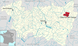
 Location of the city of Saint-Dié-des-Vosges in the Vosges department |
||
Saint-Dié-des-Vosges ( German earlier Sankt Diedolt , or Sankt Didel ) is a French commune with 19,607 inhabitants (as of January 1, 2017) in the Vosges department in the Grand Est region (until 2015 Lorraine ). It is the administrative seat ( sub-prefecture ) of the arrondissement Saint-Dié-des-Vosges , capital of the cantons Saint-Dié-des-Vosges-1 and Saint-Dié-des-Vosges-2 .
geography
Saint-Dié is located on the edge of the Ballons des Vosges Regional Nature Park on the western slope of the Vosges . The upper Meurthe flows through the urban area .
Neighboring municipalities of Saint-Dié-des-Vosges are Hurbache and Denipaire in the north, Saint-Jean-d'Ormont and Ban-de-Sapt in the northeast, Nayemont-les-Fosses in the east, Sainte-Marguerite and Saulcy-sur-Meurthe in the South-east, Taintrux in the south, Les Rouges-Eaux and Mortagne in the west and Saint-Michel-sur-Meurthe and La Voivre in the north-west.
history
The name of the city goes back to the legendary hermit Deodatus , Bishop of Nevers , who is said to have died here in 679.
In 1507 was in St. Didel of Martin Waldseemuller published a map in which the newly discovered continent of America was first named as - after Amerigo Vespucci , the Waldseemüller and Matthias Ringmann attributed the discovery.
The French influence in the region, which was part of the Holy Roman Empire , steadily increased. In the late 17th century, Alsace was annexed to France and Lorraine fell to France in 1766. Some Alsatians moved from the realm of Alsace-Lorraine , established in 1871 .
The city has been namesake of a diocese since 1777 . The 12th century cathedral and the Duval factory built by Le Corbusier between 1946 and 1952 are well worth seeing .
After the systematic and almost complete destruction by the retreating German Wehrmacht and the deportation of the male population to Germany for forced labor in November 1944, the city was rebuilt in the sober style of the 1950s. General Hermann Balck , who was responsible for the destruction, was sentenced in absentia by a French military court to 20 years of forced labor.
Population development
| year | 1962 | 1968 | 1975 | 1982 | 1990 | 1999 | 2007 |
| Residents | 23,108 | 25.117 | 25,423 | 23,759 | 22,635 | 22,569 | 21,882 |
Attractions
- The Tower of Liberty ( Tour de la Liberté ), built by Jean-Marie Hennin (architect) and Nicolas Normier (specialist in metal construction) in the Tuileries of Paris on the occasion of the bicentenary of the French Revolution in 1989. The inauguration in Saint-Dié took place on July 14, 1990. Dedication by the artist: We dedicate all the zeal and energy expended to achieve freedom to those for whom all hope of attainment ceases due to the lack of understanding and fear of others, the physical and the mentally disabled, asylum seekers and abandoned people. Height 36 meters, length of the large wings 32 meters.
- Saint-Dié cathedral (Romanesque nave, 13th century vault, massive 18th century two-tower facade). In the side view, the nave, unusual for the Romanesque, is structured by flying buttresses and buttresses (vaulting of the nave).
- Church of Our Lady (Église Notre-Dame-de-Galilée), uniformly balanced Romanesque interior with classic planar structure, vaulting with groin vaults. Massive portal tower built in front in the west.
- Cloister (cloitre gothique) between the cathedral and the Church of Our Lady, unfinished in late Gothic forms with tracery windows. On the east wing a small outer pulpit that can be entered from the cloister.
- Martins Church
- Saint Roch Chapel
- Fountain
- Claude et Duval Manufactory (architect Le Corbusier )
- Pierre-Noël Museum
- Roche Saint-Martin
- La Bure ridge
Educational institutions
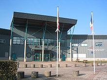
- Technical University Institute: IUT (Institut universitaire de technologie)
Sports
The footballers of the Sports Réunis Déodatiens , who played in the second division for several years around 1980 , play their home matches today at the Stade Émile Jeanpierre .
Regular events
- Festival international de geographie , every year at the beginning of October
traffic
The N59 to Nancy begins in the city in a westerly direction . In the direction of Strasbourg or Colmar , the old main connection D459 leads through the Vosges as a partly very winding pass road. Today's main route to the east is the toll Maurice-Lemaire tunnel as the N159, which then leads as the eastern branch of the N59 to almost the A35 .
The Strasbourg airport is 95 km far from the Euro Airport Basel 125 km away.
Regular regional trains connect the city with Nancy and Strasbourg. Once a day (there in the morning, back in the evening) a TGV runs directly to Paris . To the east of the neighboring municipality of Remomeix is the Saint-Dié-Remomeix regional airport ( Aérodrome de Saint-Dié - Remomeix ).
Personalities
-
sons and daughters of the town
- Catherine de Bar (1614–1698), founder of the Benedictine Sisters of the Holy Sacrament
- Jacques Augustin (1759–1832), miniature painter
- Franz Xaver von Spitzemberg (1781–1864), Württemberg Lieutenant General
- Jules Ferry (1832-1893), lawyer and politician
- Yvan Goll (1891–1950), writer
- Louis Kuehn (1922–2008), Bishop of Meaux
- Michel Kuehn (1923–2012), Bishop of Chartres
- Christian Didier (1944–2015), assassin
- Jean-Marcel Nartz (1946), German boxing official
- Sylvain Dufour (* 1982), snowboarder
- Kalidou Koulibaly (1991), football player
-
Other personalities
- Martin Waldseemüller (1472 / 1475–1520), cartographer
- Matthias Ringmann (1482–1511), philosopher and poet
- Le Corbusier (1887–1965), architect
See also: List of the Bishops of Saint-Dié
Twin cities
Web links
Individual evidence
- ^ Deodatus (Dieudonné, Dié) by St. Dié in the Ecumenical Lexicon of Saints
- ↑ Ekkart Sauser: DEODAT. In: Biographisch-Bibliographisches Kirchenlexikon (BBKL). Volume 14, Bautz, Herzberg 1998, ISBN 3-88309-073-5 , Sp. 918-919.
- ↑ Scorched Earth on gedenkorte-europa.eu, the homepage of Gedenkorte Europa 1939–1945 , accessed May 29, 2015


