
Vaux-Marquenneville
| Vaux-Marquenneville | ||
|---|---|---|

|
|
|
| region | Hauts-de-France | |
| Department | Somme | |
| Arrondissement | Abbeville | |
| Canton | Gamaches | |
| Community association | Baie de Somme | |
| Coordinates | 49 ° 59 ′ N , 1 ° 47 ′ E | |
| height | 70-122 m | |
| surface | 3.97 km 2 | |
| Residents | 87 (January 1, 2017) | |
| Population density | 22 inhabitants / km 2 | |
| Post Code | 80140 | |
| INSEE code | 80783 | |
 Church with Mairie in the background |
||

Vaux-Marquenneville ( Picard : Veux-Martchéneville ) is a northern French municipality with 87 inhabitants (at January 1, 2017) in the department of Somme in the region of Hauts-de-France . The municipality is located in the Arrondissement of Abbeville and is part of the Communauté d'agglomération de la Baie de Somme and the canton of Gamaches .
geography
The community is located in the north-north-east of Oisemont, about 3.5 kilometers away and directly adjacent to its area, and about ten kilometers west of Hallencourt . The district of Marquenneville is located in the north-west of Vaux.
history
Vaux was part of the Knights Templar in the Middle Ages . The de Riencourt family owned the place. Around 1801 Vaux and Marquenneville merged into a single municipality.
During the Second World War , from 1943 onwards, German troops built a rocket launching base at Marquenneville, which was destroyed in a bombing raid in June 1944.
The municipality was awarded the Croix de guerre .
Residents
| 1962 | 1968 | 1975 | 1982 | 1990 | 1999 | 2006 | 2011 |
|---|---|---|---|---|---|---|---|
| 74 | 78 | 75 | 62 | 72 | 67 | 78 | 75 |
Attractions
- Church of the Assumption from the 16th century with grave of the Riencourt family
- Manor house with corps de logis and pigeon house from the 17th century
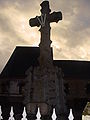
- Calvary
- War memorial

Northern front of the church
War memorial

Old signpost on Départementsstraße
-France).JPG)
_(Somme(80)-France).JPG)
(Somme(80)-France).JPG)