Cramont
| Cramont | ||
|---|---|---|
|
|
||
| region | Hauts-de-France | |
| Department | Somme | |
| Arrondissement | Abbeville | |
| Canton | Rue | |
| Community association | Ponthieu-Marquenterre | |
| Coordinates | 50 ° 9 ' N , 2 ° 3' E | |
| height | 70-136 m | |
| surface | 9.56 km 2 | |
| Residents | 303 (January 1, 2017) | |
| Population density | 32 inhabitants / km 2 | |
| Post Code | 80370 | |
| INSEE code | 80221 | |
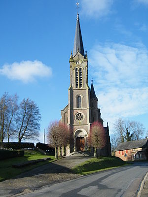
 Saint Martin Church |
||
Cramont is a northern French municipality with 303 inhabitants (at January 1, 2017) in the department of Somme in the region of Hauts-de-France . The municipality is located in the arrondissement of Abbeville and is part of the Communauté de communes Ponthieu-Marquenterre and the canton of Rue .
geography
The municipality is located around eight kilometers east of Saint-Riquier and is bounded in the west by the Roman road from Amiens to Boulogne-sur-Mer , later part of the Chaussée Brunehaut system . The districts of Le Ménage, Les Masures and part of the Les Quatre Saisons homestead (partly in the neighboring municipality of Coulonvillers ) belong to Cramont . In the north, the municipality is touched by the route of the abandoned railway line from Doullens to Abbeville (now Voie verte). The concrete runway of a military landing site from World War II is also located here . North-west of Le Ménage is the Bois de Cramont forest.
history
A Roman villa was located in the place, which was already settled in Gallo-Roman times. In 1524 it was burned down by the troops of Emperor Charles V.
In both world wars, the area was the base of field airfields , which, depending on the document, ran under Conteville , Coulonvillers , Cramont or Yvrench .
During the First World War in the winter of 1915/1916 there was a field airfield for the French air force west of Conteville.
After the outbreak of World War II , a field airfield for the British Royal Air Force (RAF) was created between Conteville, Cramont and Yvrench .
At the end of the western campaign of the German Wehrmacht , it was captured by the Luftwaffe and served for a few days in the first half of June 1940 as an operational base for the staff and I. Gruppe of Jagdgeschwader 54 (S. and I./JG 54), I. Gruppe des Jagdgeschwaders 76 (I./JG 76) and the I. Group of Jagdgeschwader 21 (i./JG 21), all of which were equipped with the Bf 109E .
During the following air battle for England , parts of the I. Group of Destroyer Wing 26 (I./ZG 26), whose Bf 110C operated here from June to November 1940, were located here.
The airfield was rarely used from 1941 and was the target of Allied air raids on several occasions. After the war, the airfield was no longer used as such, although parts of the concrete runways have been preserved.
Residents
| 1962 | 1968 | 1975 | 1982 | 1990 | 1999 | 2006 | 2011 |
|---|---|---|---|---|---|---|---|
| 327 | 337 | 297 | 269 | 262 | 262 | 287 | 303 |
Attractions
- neo-Gothic Saint-Martin church with a slender tower
- War memorial
- Moth with earth wall
