Gueschart
|
Gueschart Djéchart |
||
|---|---|---|

|
|
|
| region | Hauts-de-France | |
| Department | Somme | |
| Arrondissement | Abbeville | |
| Canton | Rue | |
| Community association | Ponthieu-Marquenterre | |
| Coordinates | 50 ° 14 ' N , 2 ° 1' E | |
| height | 45-102 m | |
| surface | 12.89 km 2 | |
| Residents | 335 (January 1, 2017) | |
| Population density | 26 inhabitants / km 2 | |
| Post Code | 80150 | |
| INSEE code | 80396 | |
 Town hall, school and post office buildings |
||
Gueschart ( Picard Djéchart ) is a French village with 335 inhabitants (at January 1, 2017) in the department of Somme in the region of Hauts-de-France . It belongs to the Arrondissement Abbeville and the canton of Rue .
geography
The community is located on the Ponthieu plateau south of the Authie river, around 9.5 kilometers east of Crécy-en-Ponthieu .
history
In Gueschart the Wehrmacht set up a rocket launch base. The place was therefore bombed in World War II.
Residents
| 1962 | 1968 | 1975 | 1982 | 1990 | 1999 | 2006 | 2011 |
|---|---|---|---|---|---|---|---|
| 477 | 453 | 406 | 380 | 345 | 324 | 320 | 321 |
Attractions
- Saint-Fursy church
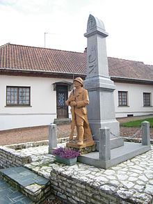
- War memorial
Web links
Commons : Gueschart - collection of images, videos and audio files


