Boismont (Somme)
| Boismont | ||
|---|---|---|

|
|
|
| region | Hauts-de-France | |
| Department | Somme | |
| Arrondissement | Abbeville | |
| Canton | Abbeville-2 | |
| Community association | Baie de Somme | |
| Coordinates | 50 ° 9 ′ N , 1 ° 41 ′ E | |
| height | 0-46 m | |
| surface | 15.57 km 2 | |
| Residents | 475 (January 1, 2017) | |
| Population density | 31 inhabitants / km 2 | |
| Post Code | 80230 | |
| INSEE code | 80110 | |
| Website | cc-baiedesommesud.fr/boismont | |
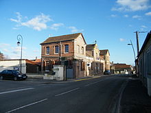
 War memorial and church |
||
Boismont ( Picard : Boémont ) is a northern French municipality with 475 inhabitants (at January 1, 2017) in the department of Somme in the region of Hauts-de-France . The municipality is located in the arrondissement of Abbeville and is part of the canton of Abbeville-2 .
geography
The municipality west-northwest of Abbeville on the south bank of the Somme and on the Canal de la Somme is around 4 km from Saint-Valery-sur-Somme . The Chemin de Fer de la Baie de Somme meter- gauge railway runs from Noyelles-sur-Mer to Cayeux-sur-Mer on the edge of the municipality of Somme Bay . Boismont includes Pinchefalise, the hamlet of Bretel and the isolated farm Ferme des Bruyères. Boismont includes the Mollières (salt pastures) at the mouth of the river.
Residents
| 1962 | 1968 | 1975 | 1982 | 1990 | 1999 | 2006 | 2011 |
|---|---|---|---|---|---|---|---|
| 538 | 511 | 509 | 526 | 551 | 497 | 468 | 468 |
administration
Mayor ( maire ) has been Michel Boutin since 2008.
Attractions
- Boismont Castle
- Castle of Pinchefalise
- Castle of Bretel
- Saint-Valery church from the 15th and 16th centuries, registered as a monument historique in 1926 .
- Saint-Valery Chapel in Pinchefalise
Individual evidence
- ↑ Eglise in the Base Mérimée of the French Ministry of Culture (French)

