Ramburelles
| Ramburelles | ||
|---|---|---|

|
|
|
| region | Hauts-de-France | |
| Department | Somme | |
| Arrondissement | Abbeville | |
| Canton | Gamaches | |
| Community association | Aumale Blangy-sur-Bresle | |
| Coordinates | 49 ° 58 ' N , 1 ° 43' E | |
| height | 104-133 m | |
| surface | 4.59 km 2 | |
| Residents | 280 (January 1, 2017) | |
| Population density | 61 inhabitants / km 2 | |
| Post Code | 80140 | |
| INSEE code | 80662 | |
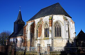
 Church of the Nativity of the Virgin |
||
Ramburelles ( Picard : Ramburelles ) is a northern French municipality with 280 inhabitants (at January 1, 2017) in the department of Somme in the region of Hauts-de-France . The municipality is located in the arrondissement of Abbeville and is part of the canton of Gamaches .
geography
The community with the hamlet of Le Bocquet is around four kilometers west-northwest of Oisemont and twelve kilometers east of Gamaches .
history
The castle was set on fire by the German occupation forces towards the end of World War II .
Residents
| 1962 | 1968 | 1975 | 1982 | 1990 | 1999 | 2006 | 2011 |
|---|---|---|---|---|---|---|---|
| 226 | 213 | 228 | 211 | 231 | 210 | 241 | 255 |
Attractions
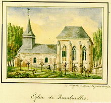
- Church of the Nativity from the 16th century
- lock
- War memorial dedicated in 1922
- Old wooden well house in front of the school
Personalities
- Eugène Delattre, politician (1830–1898), born here.
Individual evidence
Web links
Commons : Ramburelles - collection of images, videos and audio files


