
Frucourt
| Frucourt | ||
|---|---|---|
|
||
| region | Hauts-de-France | |
| Department | Somme | |
| Arrondissement | Abbeville | |
| Canton | Gamaches | |
| Community association | Baie de Somme | |
| Coordinates | 50 ° 0 ′ N , 1 ° 49 ′ E | |
| height | 48-114 m | |
| surface | 5.27 km 2 | |
| Residents | 132 (January 1, 2017) | |
| Population density | 25 inhabitants / km 2 | |
| Post Code | 80490 | |
| INSEE code | 80372 | |
.JPG) St. Martin Church |
||

Frucourt is a northern French municipality with 132 inhabitants (at January 1, 2017) in the department of Somme in the region of Hauts-de-France . The municipality is located in the Arrondissement of Abbeville and is part of the Communauté d'agglomération de la Baie de Somme and the canton of Gamaches .
geography
The community is located about six kilometers north-northeast of Oisemont and seven kilometers west of Hallencourt .
Residents
| 1962 | 1968 | 1975 | 1982 | 1990 | 1999 | 2006 | 2011 |
|---|---|---|---|---|---|---|---|
| 163 | 155 | 165 | 162 | 142 | 121 | 133 | 140 |
Attractions
- In 2004 renovated mill on the road to Oisemont from 1641, registered as Monument historique in 1931 (Base Mérimée PA00116167)
- Castle from the 17th and 18th centuries with park and pigeon house, classified or registered as a monument historique since 1980 ( Base Mérimée PA00116166)
- Saint Martin Church
- War memorial
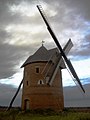
restored mill

Tower of the Saint-Martin church

Castle with park

Side entrance to the castle with pigeon house

.JPG)
.JPG)

Individual evidence
Web links
Commons : Frucourt - collection of images, videos and audio files