Villers-sur-Authie
| Villers-sur-Authie | ||
|---|---|---|

|
|
|
| region | Hauts-de-France | |
| Department | Somme | |
| Arrondissement | Abbeville | |
| Canton | Rue | |
| Community association | Ponthieu-Marquenterre | |
| Coordinates | 50 ° 19 ′ N , 1 ° 42 ′ E | |
| height | 2–33 m | |
| surface | 12.01 km 2 | |
| Residents | 474 (January 1, 2017) | |
| Population density | 39 inhabitants / km 2 | |
| Post Code | 80120 | |
| INSEE code | 80806 | |
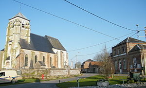
 Mairie and Assumption Church |
||
Villers-sur-Authie ( Picard : Viler-su-Eutie ) is a northern French municipality with 474 inhabitants (at January 1, 2017) in the department of Somme in the region of Hauts-de-France . The municipality is located in the arrondissement of Abbeville and is part of the Communauté de communes Ponthieu-Marquenterre and the canton of Rue .
geography
The municipality, bounded in the north by the Authie forming the département border and interspersed with small canals, is located around six kilometers north of Rue im Marquenterre , the part of the Ponthieu by the sea , west of the Autoroute A16 (Autoroute des Estuaires) and reaches in the west at the district La Gare the neighboring municipality of Quend the railway line from Amiens to Boulogne-sur-Mer . The municipality includes the hamlet of Le Marais-Noirette, the groups of houses Le Marais de Colline and Bretagne as well as La Garenne and the farms of Le Carouge and Flandre.
history
An old lock has disappeared. The current one dates back to 1687. The parish used to live from peat exploitation, the income of which was shared between the Count of Ponthieu and the Prior of Maintenay .
Residents
| 1962 | 1968 | 1975 | 1982 | 1990 | 1999 | 2006 | 2011 |
|---|---|---|---|---|---|---|---|
| 430 | 420 | 365 | 379 | 354 | 362 | 376 | 421 |
Attractions
- Church of the Assumption of the Virgin Mary (13th and 16th centuries) registered as Monument historique in 1926 with remarkable stained glass windows Eglise de l'Assomption in the Base Mérimée of the French Ministry of Culture (French)
- lock
