Érondelle
| Érondelle | ||
|---|---|---|
|
|
||
| region | Hauts-de-France | |
| Department | Somme | |
| Arrondissement | Abbeville | |
| Canton | Gamaches | |
| Community association | Baie de Somme | |
| Coordinates | 50 ° 3 ' N , 1 ° 53' E | |
| height | 6-87 m | |
| surface | 4.00 km 2 | |
| Residents | 511 (January 1, 2017) | |
| Population density | 128 inhabitants / km 2 | |
| Post Code | 80580 | |
| INSEE code | 80282 | |
| Website | http://www.erondelle.fr/public/ | |
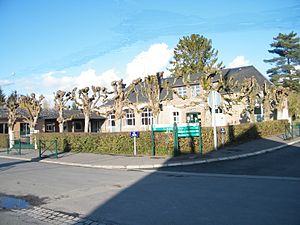
 Town hall and school building |
||
Érondelle ( Picard : Érondé ) is a northern commune with 511 inhabitants (at January 1, 2017) in the Somme department in the region of Hauts-de-France . The municipality is located in the Arrondissement of Abbeville and is part of the Communauté d'agglomération de la Baie de Somme and the canton of Gamaches .
geography
La Renardière Castle is located on the south bank of the Somme and crossed by the Rivière de Bellifontaine stream and the railway line following the Somme valley, on the heights of the Bois d'Érondelle forest.
history
The parish was part of the neighboring parish of Bailleul until 1875 .
Residents
| 1962 | 1968 | 1975 | 1982 | 1990 | 1999 | 2006 | 2011 |
|---|---|---|---|---|---|---|---|
| 319 | 321 | 362 | 412 | 424 | 434 | 496 | 499 |
Attractions
- Gallic oppidum or Roman camp Camp de César, classified as a monument historique since 1862 , encompassing the neighboring municipality of Liercourt , the remains of which rise 11 m above the level and which is bordered by a 22.5 m wide ditch, with an area of 32 ha ( Base Mérimée PA00116144)
- Garden of the Manoir de la Renardière from 1840, provisionally inventoried as Monument historique (Base Mérimée IA80000429)
- War memorial
Web links
Commons : Érondelle - collection of images, videos and audio files
