
Buigny-Saint-Maclou
| Buigny-Saint-Maclou | ||
|---|---|---|

|
|
|
| region | Hauts-de-France | |
| Department | Somme | |
| Arrondissement | Abbeville | |
| Canton | Abbeville-1 | |
| Community association | Ponthieu-Marquenterre | |
| Coordinates | 50 ° 9 ′ N , 1 ° 49 ′ E | |
| height | 33-71 m | |
| surface | 7.30 km 2 | |
| Residents | 517 (January 1, 2017) | |
| Population density | 71 inhabitants / km 2 | |
| Post Code | 80132 | |
| INSEE code | 80149 | |
| Website | http://www.cc-nouvion.fr/public/?code=buigny-saint-maclou | |
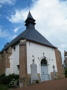
 Saint-Maclou Church |
||

Buigny-Saint-Maclou ( Picard : Bugny-Saint-Maclou ) is a northern French municipality with 517 inhabitants (at January 1, 2017) in the Somme department in the region of Hauts-de-France . The municipality is located in the arrondissement of Abbeville and is part of the Communauté de communes Ponthieu-Marquenterre and the canton of Abbeville-1 .
geography
The municipality is located immediately north of Abbeville on the former Route nationale 1 . Abbeville airfield is located within the municipality and has three runways (one of which is paved). The municipality includes the Les Épis settlement and the isolated farmsteads Bonneval, Blanche Abbaye and Saint-Nicolas-des-Essarts.
history
Until the 14th century the place was a Templar estate .
Residents
| 1962 | 1968 | 1975 | 1982 | 1990 | 1999 | 2006 | 2011 |
|---|---|---|---|---|---|---|---|
| 352 | 335 | 292 | 467 | 548 | 523 | 520 | 515 |
administration
Mayor ( maire ) has been Éric Mouton since 2008.
traffic
Attractions
Saint-Maclou Church

Burial chapel

lock
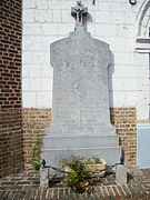
War memorial

school


- Saint-Maclou church from the end of the 16th century with a relic of the patron saint
- Grave chapel of the Tillette family