Saigneville
| Saigneville | ||
|---|---|---|
|
|
||
| region | Hauts-de-France | |
| Department | Somme | |
| Arrondissement | Abbeville | |
| Canton | Abbeville-2 | |
| Community association | Baie de Somme | |
| Coordinates | 50 ° 8 ' N , 1 ° 43' E | |
| height | 2-59 m | |
| surface | 12.86 km 2 | |
| Residents | 393 (January 1, 2017) | |
| Population density | 31 inhabitants / km 2 | |
| Post Code | 80230 | |
| INSEE code | 80691 | |
| Website | www.cc-baiedesommesud.fr/saigneville | |
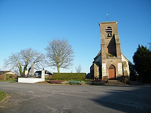
 Saint-Fuscien church |
||
Saigneville ( Picard : Sainneville ) is a northern French municipality with 393 inhabitants (at January 1, 2017) in the department of Somme in the region of Hauts-de-France . The municipality is located in the arrondissement of Abbeville and is part of the canton of Abbeville-2 .
geography
The municipality on the south bank of the Somme , touched by the railway line from Abbeville to Eu (Seine-Maritime) , is bounded in the east by the Trie , a left tributary of the Somme. North of the Canal de la Somme , the hamlets of Petit-Port and Les Amourettes belong to Saigneville.
history
Below Saigneville, the Gué de Blanquetaque ford crossed the Somme until the Somme Canal was created in 1786 . A ferry is also mentioned. The Battle of Blanchetaque took place at the ford in the Hundred Years War in 1346 .
Salt was extracted in Les Salines.
Residents
| 1962 | 1968 | 1975 | 1982 | 1990 | 1999 | 2006 | 2011 |
|---|---|---|---|---|---|---|---|
| 403 | 365 | 330 | 351 | 375 | 385 | 401 | 392 |
administration
Mayor ( maire ) has been Jean Gorriez since 2014.
Attractions
- Saint-Fuscien church

