Friville escarbotin
| Friville escarbotin | ||
|---|---|---|

|
|
|
| region | Hauts-de-France | |
| Department | Somme | |
| Arrondissement | Abbeville | |
| Canton | Friville-Escarbotin (main town) | |
| Community association | Vimeu | |
| Coordinates | 50 ° 5 ' N , 1 ° 33' E | |
| height | 55-112 m | |
| surface | 8.86 km 2 | |
| Residents | 4,569 (January 1, 2017) | |
| Population density | 516 inhabitants / km 2 | |
| Post Code | 80130 | |
| INSEE code | 80368 | |
| Website | http://www.friville-escarbotin.com/content/ | |
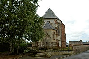
 The Saint-Etienne church in Friville |
||
Friville-Escarbotin ( Picard : Freuvile-Ésquérbotin ) is a northern French municipality with 4569 inhabitants (at January 1, 2017) in the department of Somme in the region of Hauts-de-France . The municipality is located in the arrondissement of Abbeville and is part of the Communauté de communes du Vimeu and capital of the canton of Friville-Escarbotin .
geography
The municipality, whose territory is touched in the south by the D925, lies at the intersection of the D2, D102 and D229, around 22 km west of Abbeville and eleven km east of Eu (Seine-Maritime) . The heavily industrialized community consists of the merged districts of Friville in the south, Escarbotin to the north and Belloy-sur-Mer in the northwest.
Residents
| 1962 | 1968 | 1975 | 1982 | 1990 | 1999 | 2006 | 2011 |
|---|---|---|---|---|---|---|---|
| 4076 | 4363 | 4693 | 4844 | 4737 | 4646 | 4534 | 4604 |
administration
Mayor ( maire ) has been David Lefèvre since 2008.
Attractions
- Saint-Étienne church in Friville, with a choir registered as a monument historique since 1981
- Saint-Hubert church in Escarbotin
- Belloy Chapel
- old castle in Friville, now old people's home
- War memorial
- Locksmith Museum
- Montmignon Castle, now the Tourist Office
Individual evidence
- ↑ Église in the Base Mérimée of the French Ministry of Culture (French)
