
Noyelles-en-Chaussée
| Noyelles-en-Chaussée | ||
|---|---|---|
|
||
| region | Hauts-de-France | |
| Department | Somme | |
| Arrondissement | Abbeville | |
| Canton | Rue | |
| Community association | Ponthieu-Marquenterre | |
| Coordinates | 50 ° 13 ′ N , 1 ° 59 ′ E | |
| height | 58-106 m | |
| surface | 10.47 km 2 | |
| Residents | 243 (January 1, 2017) | |
| Population density | 23 inhabitants / km 2 | |
| Post Code | 80150 | |
| INSEE code | 80599 | |
 Mairie and Community Hall |
||

Noyelles-en-Chaussée ( Picard : Noéyelle-in-Cœuchie ) is a northern French municipality with 243 inhabitants (at January 1, 2017) in the department of Somme in the region of Hauts-de-France . The municipality is located in the arrondissement of Abbeville and is part of the Communauté de communes Ponthieu-Marquenterre and the canton of Rue .
geography
The community is located on the Ponthieu plateau on the D108 (part of a Roman road and the system of Chaussée Brunehaut ) and D56 from Crécy-en-Ponthieu, about nine kilometers west-northwest, towards Bernaville .
history
During the Second World War , the Wehrmacht built a rocket launch pad in Noyelles.
Residents
| 1962 | 1968 | 1975 | 1982 | 1990 | 1999 | 2006 | 2011 |
|---|---|---|---|---|---|---|---|
| 363 | 333 | 303 | 297 | 268 | 248 | 258 | 258 |
Attractions
- Saint-Pierre church
- lock
- Chapel of 300 corpses in memory of three hundred knights who died in the Battle of Crécy
- War memorial
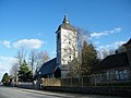
Saint-Pierre church

lock

Chapel of 300 corpses

War memorial

.JPG)


Web links
Commons : Noyelles-en-Chaussée - collection of images, videos and audio files