Regnière-Écluse
| Regnière-Écluse | ||
|---|---|---|
|
|
||
| region | Hauts-de-France | |
| Department | Somme | |
| Arrondissement | Abbeville | |
| Canton | Rue | |
| Community association | Ponthieu-Marquenterre | |
| Coordinates | 50 ° 17 ′ N , 1 ° 46 ′ E | |
| height | 5–60 m | |
| surface | 9.54 km 2 | |
| Residents | 126 (January 1, 2017) | |
| Population density | 13 inhabitants / km 2 | |
| Post Code | 80120 | |
| INSEE code | 80665 | |
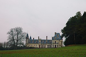
 The lock |
||
Regnière-Écluse ( Picard : Érgnére-Écluse ) is a northern French municipality with 126 inhabitants (at January 1, 2017) in the department of Somme in the region of Hauts-de-France . The municipality is located in the arrondissement of Abbeville and is part of the Communauté de communes Ponthieu-Marquenterre and the canton of Rue .
geography
The community on the edge of the Marquenterre , largely surrounded by forests , is bordered in the south by the river Maye and in the west by the former Route nationale 1 . It is about eight kilometers east of Rue . In the southeast it borders on the Forêt Domaniale de Crécy forest. The Wacogne and Campigneulle farms belong to the municipality.
Toponymy and History
The place is called Ragneri exclusa in the year 644. Gautier II Tirel ruled after 1130.
Residents
| 1962 | 1968 | 1975 | 1982 | 1990 | 1999 | 2006 | 2011 |
|---|---|---|---|---|---|---|---|
| 146 | 157 | 154 | 120 | 125 | 122 | 134 | 137 |
administration
Mayor ( maire ) has been Pierre Bost since 2014.
Attractions
- Castle from 1553 with landscaped park, rebuilt in the 19th century in neo-Gothic knightly style, classified as a monument historique after entries in 1976 and 2005 in 2006
- Saint-Martin church with war memorial
Individual evidence
- ↑ Ancien domaine du comte d'Hinnisdal (également sur communes de Vron et Machy) in the Base Mérimée of the French Ministry of Culture (French)

