Machiel
| Machiel | ||
|---|---|---|
|
|
||
| region | Hauts-de-France | |
| Department | Somme | |
| Arrondissement | Abbeville | |
| Canton | Rue | |
| Community association | Ponthieu-Marquenterre | |
| Coordinates | 50 ° 16 ′ N , 1 ° 50 ′ E | |
| height | 17-76 m | |
| surface | 6.61 km 2 | |
| Residents | 156 (January 1, 2017) | |
| Population density | 24 inhabitants / km 2 | |
| Post Code | 80150 | |
| INSEE code | 80496 | |
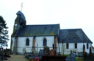
 Saint-Pierre church |
||
Machiel is a northern French municipality with 156 inhabitants (at January 1, 2017) in the department of Somme in the region of Hauts-de-France . The municipality is located in the arrondissement of Abbeville and is part of the Communauté de communes Ponthieu-Marquenterre and the canton of Rue .
geography
The municipality, through which the river Maye flows, is around twelve kilometers east of Rue and 4.5 kilometers west of Crécy-en-Ponthieu on the northern edge of the Forêt de Crécy domain forest. The north-facing farmsteads Le Grand Rossignol and Le Petit Rossignol as well as Wacourt Castle in the far north belong to the municipality.
history
Until the 18th century, the domain was owned by the Benedictine abbey in Forest-Montiers . The castle on site was demolished in 1820.
Residents
| 1962 | 1968 | 1975 | 1982 | 1990 | 1999 | 2006 | 2011 |
|---|---|---|---|---|---|---|---|
| 193 | 175 | 173 | 169 | 177 | 171 | 161 | 169 |
Attractions
- Saint-Pierre church
- War memorial
- Castle and park in Wacourt from the third quarter of the 18th century Jardin d'agrément du château de Wacourt in the Base Mérimée of the French Ministry of Culture (French)
