Yengo National Park
| Yengo National Park | ||
|---|---|---|
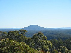
| View of Mount Yengo from Finchley Trig | ||
|
|
||
| Location: | New South Wales , Australia | |
| Specialty: | Sandstone plateau, canyons, warm temperate rainforest | |
| Next city: | 80 km northwest of Gosford | |
| Surface: | 1,634 km² | |
| Founding: | March 11, 1988 | |
| Visitors: | 24,000 (1997) | |
The Yengo National Park (English Yengo National Park ) is a 489 km² national park in New South Wales , Australia , about 100 km northwest of Sydney . It is located in the area of the Blue Mountains , which was declared a World Heritage Site in 2000 , and adjoins the Wollemi National Park to the east ; separated from Putty Road .
Location and access
The park with a length of over 70 km and a width of up to 40 km is located in the middle of the triangle spanned by the cities of Sydney, Lithgow and Singleton . The western part of the park is accessible from Windsor via Putty Road (State Route 69) . The eastern part of the park can be reached from Wisemans Ferry via Settlers Road . Numerous paths lead through the park itself, although in most cases only four-wheel drive vehicles can drive them.
geology
In the Yengo National Park, the Macdonald River has cut deeply and in wide meanders into a sandstone plateau. The typical labyrinth of steeply rising rock ridges and deep gorges was formed along the course of the river. The oldest rock that is revealed at 230 million years ago comes from the Narrabeen Group . Above that, various layers of slate , sandstone and conglomerate follow up to the top layer, which covers about two thirds of the park, the Hawkesbury sandstone . The remaining third is covered by a tertiary basalt layer. The dominant elevations of Mount Yengo (668 m) and Mount Wareng (594 m) consist of this.
Flora and fauna
Compared to the coast and the higher parts of the Blue Mountains to the west, the park receives relatively little rainfall. The vegetation on the plateaus and the north-western slopes therefore mostly consists of low forest with hard foliage . In the more humid areas, especially on the southern slopes and in the eastern part, there are also stands with high eucalyptus forests , in small niches at protected water points and gorges occasional temperate rainforest thrives .
43 species of marsupials have been counted in the park , including the critically endangered brush-tailed rock kangaroos . In addition to the wart honeyeater , which is also threatened with extinction, there are another 128 bird species, more than 17 amphibians and over 37 reptile species in the park .
history
The land was formerly inhabited by Aborigines . In the north it was the tribe of the Wonaruah ; in the south the Darkinjung . Two Aboriginal art sites can be visited: Burragurra and Finchley . In both places there are petroglyphs in the style of the Sydney rock engravings .
Web links
- Official site of the park (English)
Individual evidence
- ↑ NSW National Parks & Wildlife Service: The Greater Blue Mountains World Heritage Nomination (PDF; 5.9 MB), page 239. (English)
- ↑ Australia Easy Read - Road and 4WD Atlas . Hema Maps, Brisbane 2007, ISBN 978-1-86500-395-5 .
- ↑ a b c Official website of the park. DECCW , accessed April 20, 2010 .
- ↑ NSW WILDERNESS RED INDEX. Colong Foundation for Wilderness Ltd, accessed March 4, 2013 .
- ↑ a b Yengo National Park and Parr State Recreation Aread - Draft Plan of Management. (PDF; 441 kB) DECCW , accessed on April 20, 2010 (English).
- ^ NSW National Parks and Wildlife Service Yengo National Park Management Plan , page 32


