
Bailleul (Somme)
| Bailleul | ||
|---|---|---|
.svg)
|
|
|
| region | Hauts-de-France | |
| Department | Somme | |
| Arrondissement | Abbeville | |
| Canton | Gamaches | |
| Community association | Baie de Somme | |
| Coordinates | 50 ° 2 ′ N , 1 ° 51 ′ E | |
| height | 7–112 m | |
| surface | 8.62 km 2 | |
| Residents | 266 (January 1, 2017) | |
| Population density | 31 inhabitants / km 2 | |
| Post Code | 80490 | |
| INSEE code | 80051 | |
.JPG) Town hall and school building |
||

Bailleul ( Picard : Bailleu ) is a northern French municipality with 266 inhabitants (at January 1, 2017) in the department of Somme in the region of Hauts-de-France . The municipality is located in the Arrondissement of Abbeville and is part of the Communauté d'agglomération de la Baie de Somme and the canton of Gamaches .
geography
The municipality, criss-crossed by several valleys, is located north of the municipal area of Hallencourt , about nine kilometers south of Abbeville . Bailleul includes the districts of Bellifontaine on the Rivière de Bellifontaine stream , which continues in the Somme valley as Rivière de Bray in the east, Grandsart in the south and Fréchencourt in the north and the remote Coquerel Castle.
history
In 1875, Érondelle in the Somme valley was spun off as an independent municipality.
Residents
| 1962 | 1968 | 1975 | 1982 | 1990 | 1999 | 2006 | 2011 |
|---|---|---|---|---|---|---|---|
| 240 | 225 | 226 | 248 | 223 | 232 | 255 | 278 |
Attractions
- Saint Martin Church
- Bellifontaine Church
- Château de Coquerel
- Floor cross
- War memorial
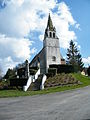
Saint Martin Church

Bellifontaine Church
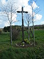
Floor cross
.JPG)

