Chaptuzat
| Chaptuzat | ||
|---|---|---|

|
|
|
| region | Auvergne-Rhône-Alpes | |
| Department | Puy-de-Dôme | |
| Arrondissement | Riom | |
| Canton | Aigueperse | |
| Community association | Plaine Limagne | |
| Coordinates | 46 ° 2 ' N , 3 ° 11' E | |
| height | 352-535 m | |
| surface | 8.24 km 2 | |
| Residents | 491 (January 1, 2017) | |
| Population density | 60 inhabitants / km 2 | |
| Post Code | 63260 | |
| INSEE code | 63090 | |
Chaptuzat is a municipality with 491 inhabitants (as of January 1 2017) in central France Puy-de-Dôme in the region Auvergne Rhône-Alpes . The municipality belongs to the arrondissement of Riom and the canton of Aigueperse .
location
Chaptuzat is about 15 kilometers north-northeast of Riom . The Buron River has its source here . Chaptuzat is surrounded by the neighboring communities of Vensat in the north, Aigueperse in the east, Artonne in the south and Saint-Agoulin in the west.
Population development
| year | 1962 | 1968 | 1975 | 1982 | 1990 | 1999 | 2008 | 2013 |
| Residents | 320 | 343 | 300 | 322 | 351 | 366 | 407 | 487 |
| Source: Cassini and INSEE | ||||||||
Attractions
- Saint-Pierre church, historique monument since 1925
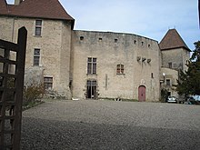
- La Roche Aigueperse Castle from the 12th / 13th centuries Century, Monument historique since 1965
Personalities
- Michel de L'Hospital (1505–1573), statesman and writer, born at La Roche Aigueperse Castle
Web links
Commons : Chaptuzat - collection of images, videos and audio files

