
Pontgibaud
| Pontgibaud | ||
|---|---|---|
.svg)
|
|
|
| region | Auvergne-Rhône-Alpes | |
| Department | Puy-de-Dôme | |
| Arrondissement | Riom | |
| Canton | Saint-Ours | |
| Community association | Chavanon Combrailles et Volcans | |
| Coordinates | 45 ° 50 ′ N , 2 ° 51 ′ E | |
| height | 639-779 m | |
| surface | 4.59 km 2 | |
| Residents | 756 (January 1, 2017) | |
| Population density | 165 inhabitants / km 2 | |
| Post Code | 63230 | |
| INSEE code | 63285 | |
| Website | http://www.ville-pontgibaud.fr/ | |
 Town hall (Mairie) of Pontgibaud |
||

Pontgibaud is a French municipality with 756 inhabitants (as of January 1 2017) in the department of Puy-de-Dôme in the region Auvergne Rhône-Alpes . It belongs to the arrondissement of Riom and the canton of Saint-Ours (until 2015: canton of Pontgibaud ). The inhabitants are called Gibaldipontins .
geography
Pontgibaud is about 19 kilometers west-northwest of Clermont-Ferrand . Pontgibaud is surrounded by the neighboring communities of Bromont-Lamothe in the north and west, Saint-Ours in the north and east and Saint-Pierre-le-Chastel in the south.
Population development
| year | 1962 | 1968 | 1975 | 1982 | 1990 | 1999 | 2008 | 2013 |
| Residents | 654 | 724 | 723 | 750 | 801 | 776 | 768 | 705 |
| Source: Cassini and INSEE | ||||||||
Attractions
- Saint-Benoît church from the 13th century, renovations from the 19th century
- Pontgibaud Castle of the Dauphins from the 12th century with renovations from the 15th century as well as a park, monument historique
- Fortification with gates, monument historique
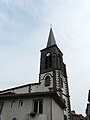
Saint-Benoît church

Castle or Palace Pontgibaud

Site fortification


Personalities
- Henri Vidal (1919–1959), actor, buried here
- Jean-Baptiste Donnet (1923–2012), chemist
Web links
Commons : Pontgibaud - collection of images, videos and audio files