
Saint-Pierre-le-Chastel
| Saint-Pierre-le-Chastel | ||
|---|---|---|
.svg)
|
|
|
| region | Auvergne-Rhône-Alpes | |
| Department | Puy-de-Dôme | |
| Arrondissement | Riom | |
| Canton | Saint-Ours | |
| Community association | Chavanon Combrailles et Volcans | |
| Coordinates | 45 ° 50 ′ N , 2 ° 51 ′ E | |
| height | 665-873 m | |
| surface | 17.45 km 2 | |
| Residents | 434 (January 1, 2017) | |
| Population density | 25 inhabitants / km 2 | |
| Post Code | 63230 | |
| INSEE code | 63385 | |
 View of Saint-Pierre-le-Chastel |
||

Saint-Pierre-le-Chastel is a French municipality with 434 inhabitants (as of January 1 2017) in the department of Puy-de-Dôme in the region Auvergne Rhône-Alpes . It belongs to the arrondissement of Riom and the canton of Saint-Ours (until 2015: canton of Pontgibaud ). The inhabitants are called Castelpétrussiens .
geography
Saint-Pierre-le-Chastel is about 18 kilometers west-northwest of Clermont-Ferrand . Saint-Pierre-le-Chastel is surrounded by the neighboring communities of Bromont-Lamothe in the north and north-west, Pontgibaud in the north, Saint-Ours in the north-east, Mazaye in the south and east and Gelles in the west and south-west.
Population development
| year | 1962 | 1968 | 1975 | 1982 | 1990 | 1999 | 2008 | 2013 |
| Residents | 417 | 354 | 339 | 310 | 326 | 320 | 359 | 403 |
| Source: Cassini and INSEE | ||||||||
Attractions
- Saint-Pierre-aux-Liens church from the 11th century
- Bonnebaud Castle from the 13th century with renovations from the 19th century, Monument historique since 2003
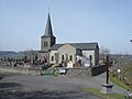
Saint-Pierre-aux-Liens church
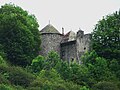
Bonnebaud Castle


Web links
Commons : Saint-Pierre-le-Chastel - Collection of images, videos and audio files