
Sauret-Besserve
| Sauret-Besserve | ||
|---|---|---|
|
||
| region | Auvergne-Rhône-Alpes | |
| Department | Puy-de-Dôme | |
| Arrondissement | Riom | |
| Canton | Saint-Éloy-les-Mines | |
| Community association | Pays de Saint-Éloy | |
| Coordinates | 46 ° 0 ′ N , 2 ° 48 ′ E | |
| height | 428-704 m | |
| surface | 10.33 km 2 | |
| Residents | 164 (January 1, 2017) | |
| Population density | 16 inhabitants / km 2 | |
| Post Code | 63390 | |
| INSEE code | 63408 | |

Sauret-Besserve is a French municipality with 164 inhabitants (at January 1, 2017) in the department of Puy-de-Dôme in the region Auvergne Rhône-Alpes (before 2016 Auvergne ). The municipality belongs to the arrondissement of Riom and the canton of Saint-Éloy-les-Mines (until 2015 Saint-Gervais-d'Auvergne ).
location
Sauret-Besserve is about 29 kilometers west-northwest of Riom and about 35 kilometers northwest of Clermont-Ferrand . Sauret-Besserve is surrounded by the neighboring communities of Saint-Gervais-d'Auvergne in the north, Queuille in the east and south-east, Saint-Georges-de-Mons in the south and south-east, Les Ancizes-Comps in the south and Saint-Priest-des-Champs in the west and southwest.
Population development
| year | 1962 | 1968 | 1975 | 1982 | 1990 | 1999 | 2006 | 2013 |
| Residents | 235 | 231 | 185 | 170 | 199 | 192 | 180 | 175 |
| Source: Cassini and INSEE | ||||||||
Attractions
- Saint-Pierre church
- Besserve reservoir
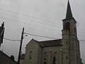
Saint-Pierre church

Besserve reservoir
.JPG)

Community partnerships
There is a partnership with the German municipality of Hohentengen in Baden-Württemberg.