
Youx
| Youx | ||
|---|---|---|
.svg)
|
|
|
| region | Auvergne-Rhône-Alpes | |
| Department | Puy-de-Dôme | |
| Arrondissement | Riom | |
| Canton | Saint-Éloy-les-Mines | |
| Community association | Pays de Saint-Éloy | |
| Coordinates | 46 ° 9 ' N , 2 ° 48' E | |
| height | 495-743 m | |
| surface | 19.13 km 2 | |
| Residents | 915 (January 1, 2017) | |
| Population density | 48 inhabitants / km 2 | |
| Post Code | 63700 | |
| INSEE code | 63471 | |
_%C3%A9cole.JPG) Mairie (left) and school (right) |
||

Youx is a French municipality with 915 inhabitants (at January 1, 2017) in the department of Puy-de-Dôme in the region Auvergne Rhône-Alpes . It belongs to the Arrondissement of Riom and the municipality of Pays de Saint-Éloy . The residents call themselves Vagurods .
geography
Youx is located in the Combraille landscape in the north of the Massif Central , about halfway between Riom and Montluçon . The neighboring municipalities are Montaigut in the north, Saint-Éloy-les-Mines in the north-east, Menat and Neuf-Église in the south-east, Teilhet in the south, Le Quartier in the south-west and La Crouzille in the north-west.
The upper Bouble flows through the municipal area of 1913 hectares . Immediately to the west of the village of Youx, the Forêt Domaniale du Quartier extends the largest forest area in the municipality. This mixed forest is also the highest point in the municipality at 743 m, while Youx's town hall is 623 m above sea level.
In addition to the Youx village, Youx also includes other villages and hamlets:
- Montjoie, the largest village in the parish
- Laval
- Les Cros
- La Cité de Pigoil, a former mining settlement
- Le Sucharet
- Le Puy Malet
- Ladoux
- Montchaujoux
Population development
By the middle of the 19th century, Youx had a population of between 600 and 700. With the coal mining in the nearby mines of Saint-Éloy-les-Mines and the construction of workers' accommodation in Youx, the number of residents grew and reached its peak in 1954 with 1945 residents. The closure of the last mine in 1978 led to an intensification of the already latent population decline.
| 1962 | 1968 | 1975 | 1982 | 1990 | 1999 | 2006 | 2017 | ||
|---|---|---|---|---|---|---|---|---|---|
| 1860 | 1747 | 1512 | 1297 | 1115 | 1002 | 1010 | 915 | ||
| Sources: Cassini and INSEE | |||||||||
Attractions
_%C3%A9glise_(02).JPG)
- 19th century church Saint-Martin in Youx
- Montjoie Chapel
- Fallen memorial
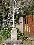
- several wayside crosses
- Crossroads in Youx


_croix_de_chemin_rue_de_la_Mairie.JPG)
_croix_de_chemin_route_de_Pionsat.JPG)
_croix_de_cimeti%C3%A8re.JPG)
Economy and Infrastructure
There are 15 farms in the municipality (growing of grain and vegetables, breeding horses, cattle, goats and sheep, and keeping pigs).
The trunk road from Auzances via Pionsat to Montaigut (D 988) runs through the municipality of Youx . The railway line from Lapeyrouse to Volvic with a stop in Youx was closed in 2007.