
Charbonnières-les-Vieilles
| Charbonnières-les-Vieilles | ||
|---|---|---|

|
|
|
| region | Auvergne-Rhône-Alpes | |
| Department | Puy-de-Dôme | |
| Arrondissement | Riom | |
| Canton | Saint-Georges-de-Mons | |
| Community association | Combrailles Sioule et Morge | |
| Coordinates | 46 ° 0 ′ N , 3 ° 0 ′ E | |
| height | 472-755 m | |
| surface | 32.62 km 2 | |
| Residents | 1,075 (January 1, 2017) | |
| Population density | 33 inhabitants / km 2 | |
| Post Code | 63410 | |
| INSEE code | 63093 | |
| Website | charbovieilles.pagesperso-orange.fr/ | |
 View of Charbonnières-les-Vieilles |
||

Charbonnières-les-Vieilles is a French commune with 1,075 inhabitants (as of January 1 2017) in the department of Puy-de-Dôme in the region Auvergne Rhône-Alpes (before 2016 Auvergne ). It belongs to the arrondissement of Riom and the canton of Saint-Georges-de-Mons (until 2015 Manzat ).
geography
Charbonnières-les-Vieilles is located about 13 kilometers northwest of Riom and about 23 kilometers north-northwest of Clermont-Ferrand in the Monts Dômes in the Regional Nature Park Volcans d'Auvergne ( French Parc naturel régional des Volcans d'Auvergne ). Charbonnières-les-Vieilles is surrounded by the neighboring communities of Blot-l'Église in the north and north-west, Saint-Hilaire-la-Croix in the north and north-east, Montcel in the north-east, Combronde in the east, Teilhède in the south-east, Loubeyrat in the south, Manzat in the Southwest and Saint-Angel in the west.
Population development
| 1962 | 1968 | 1975 | 1982 | 1990 | 1999 | 2006 | 2013 |
|---|---|---|---|---|---|---|---|
| 876 | 838 | 730 | 866 | 880 | 864 | 899 | 1,029 |
| Source: Cassini and INSEE | |||||||
Attractions
- Saint-Pierre church
- 19th century Lord Davis Castle
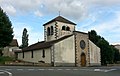
Saint-Pierre church
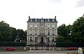
Lord Davis Castle

