Artonne
| Artonne | ||
|---|---|---|

|
|
|
| region | Auvergne-Rhône-Alpes | |
| Department | Puy-de-Dôme | |
| Arrondissement | Riom | |
| Canton | Aigueperse | |
| Community association | Plaine Limagne | |
| Coordinates | 46 ° 0 ′ N , 3 ° 9 ′ E | |
| height | 334-532 m | |
| surface | 17.48 km 2 | |
| Residents | 898 (January 1, 2017) | |
| Population density | 51 inhabitants / km 2 | |
| Post Code | 63460 | |
| INSEE code | 63012 | |
| Website | http://artonne.pagesperso-orange.fr/ | |
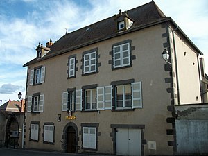
 Artonne Town Hall (Mairie) |
||
Artonne is a municipality with 898 inhabitants (as of January 1 2017) in central France Puy-de-Dôme in the region Auvergne Rhône-Alpes . The municipality belongs to the arrondissement of Riom and the canton of Aigueperse .
location
Artonne is about 14 kilometers north-northeast of Riom . Artonne is surrounded by the neighboring communities of Saint-Agoulin in the north, Chaptuzat in the north and northeast, Aigueperse in the east and northeast, Aubiat in the southeast, La Moutade and Saint-Myon in the south, Combronde in the southwest and Jozerande in the west and northwest.
history
Artonne already appeared in Gregory of Tours as Artona or Arthona and is as a village ( vicus ) of the Arverni described.
Population development
| year | 1962 | 1968 | 1975 | 1982 | 1990 | 1999 | 2008 | 2013 |
| Residents | 721 | 714 | 685 | 753 | 779 | 762 | 773 | 845 |
| Source: Cassini and INSEE | ||||||||
Attractions
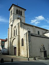
- Saint-Martin church from the 12th century, monument historique since 1886
- Le Verger Castle from the 17th / 18th centuries Century, since 2010 Monument historique
Web links
Commons : Artonne - collection of images, videos and audio files
Remarks
- ^ Gregor von Tours, Gloria confessorum 5. Cf. Max Ihm : Artona vicus . In: Paulys Realencyclopadie der classischen Antiquity Science (RE). Volume II, 2, Stuttgart 1896, col. 1460.

