
Condé-sur-l'Escaut
| Condé-sur-l'Escaut | ||
|---|---|---|
_Nord-France.svg)
|
|
|
| region | Hauts-de-France | |
| Department | North | |
| Arrondissement | Valenciennes | |
| Canton | Marly | |
| Community association | Valenciennes Métropole | |
| Coordinates | 50 ° 27 ' N , 3 ° 35' E | |
| height | 10-52 m | |
| surface | 18.40 km 2 | |
| Residents | 9,698 (January 1, 2017) | |
| Population density | 527 inhabitants / km 2 | |
| Post Code | 59163 | |
| INSEE code | 59153 | |
| Website | https://www.conde59.fr/ | |
 Town hall of Condé-sur-l'Escaut |
||

Condé-sur-l'Escaut ( Dutch Konde ) is a French municipality with 9698 inhabitants (at January 1, 2017) in Nord in the region of Hauts-de-France . The municipality belongs to the canton of Marly (until 2015: canton of Condé-sur-l'Escaut ).
Grégory Lelong of the Union des démocrates et indépendants (UDI) has been the mayor of the municipality since 2014 .
geography
Condé-sur-l'Escaut is located in northern France not far from the Belgian border on the edge of the Scarpe-Schelde Regional Nature Park . The straight line distance is around 200 kilometers from Paris , 40 kilometers from Lille and 70 kilometers from Brussels . Originally, the city was at the mouth of the groves in the Scheldt (French: Escaut), which was south of today's lock. However, since they were straightened , the two rivers have run away from the center. Close to the city center is the harbor on a 1,982 disused section of the 1818 commissioned in navigation channel Canal de Mons à Condé .
Surname
The place name is derived from the Celtic word Condat (e) (confluence). In Condé the groves - now diverted - flowed into the Escaut. In the Gallo-Roman times the place was called Condatum, in the 14th century then Conde and later Condé.
In the course of the French Revolution , Condé was renamed "Nord Libre", on October 8, 1810, the city was given its old name back. Since there were numerous places with the same name in France, the addition "-sur-l'Escaut" (German: on the Scheldt) was added in 1887.
history


.jpg)
Around the year 46 BC The Nervi , who opposed Gaius Julius Caesar's campaign of conquest , are said to have built a castle in Condé. Around 633 the Scottish priest Wasnon built a church in Condé. The place was first mentioned in a document in 870 in the Treaty of Meerssen .
After the Vikings had devastated the area, they established their fortified winter quarters in Condé in 882 . Expelled by the Count of Mons , they conquered the place a second time, but ultimately had to admit defeat. From then on Condé belonged to the county of Mons.
Around 1020 the place was divided into two manors, that of the noble families Condé-Bailleul-Moriamez and Oisy- Avesnes . It was not until 1531 that they were united by Wilhelm von Roggendorf .
From 1171, James I of the Avesnes family ruled over Condé. In 1174 he had the Bishop of Cambrai murdered. Thereupon Balduin V , Count of Hainaut , destroyed Condé in the same year and had Jacob's castle razed . After the peace agreement, the donjon was rebuilt more splendidly than before. In 1326 the entire nobility of the country was invited to a major tournament in Condé.
In 1339 the Flemings rose against their ruler Ludwig I and holed up in Condé. The French King Louis XI. tried in 1477 initially in vain to take Condé. The following year he laid siege to the city again, which fell after heavy resistance on April 27th. After the arrival of Archduke Maximilian I , the French set the most important buildings (except the church) on fire and abandoned Condé after a month.
In 1528, Charles V ordered the construction of flanking towers for the artillery . In 1580 they did not prevent the Huguenots from entering the place and looting the church.
On August 25, 1649, the Count of Harcourt conquered the place, but gave it up again because of fear that he would not be able to hold it over the winter. That year the Spaniards captured Condé. In 1655 the French took Condé under Henri de Turenne , who was recaptured twelve months later by Louis II. De Bourbon , the third Prince de Condé . From 1660 the Spanish reinforced the city wall and built a bastion . On April 6, 1676, shortly before the completion of the fortifications, the city finally came under French rule after the siege and capture by 40,000 soldiers. The Treaty of Nijmegen secured Louis XIV on August 10, 1678 his new possession. Barracks were built and the defensive walls were completed. The builder of the fortifications was Sébastien Le Prestre de Vauban , who also perfected a system of largely submerging the city's surroundings in order to defend it.
Between 1751 and 1755, the Saint-Wasnon church was built on the site of the old parish church. The client was Emmanuel von Croÿ , architect Pierre Contant d'Ivry , who later also designed the La Madeleine church in Paris .
In 1793 Condé was besieged for three months by British-Austrian troops, opponents of the French Revolution , and finally captured. It was not until August 30, 1794 that the city could be recaptured by Barthélemy Louis Joseph Schérer . Thanks to Chappe's telegraph system , this message quickly reached Paris .
In the 19th century some barracks and defenses were built, but the garrison was ultimately reduced in size. In 1901 Condé lost its status as a garrison site.
Condé is located in a coal field that stretches from Belgium to Valenciennes . Due to quarrying , the area subsided . B. the lake Étang Chabaud Latour. Northeast of the city, a first in 1901 Schacht of the pit Ledoux drilled , ceased production there in late 1988 again. One of the winding towers has been preserved as a monument .
To facilitate the construction of industrial facilities, part of the fortifications was demolished in 1923. After the occupation by the German Wehrmacht in World War II , the 5th US Armored Division liberated the city on September 2, 1944.
Residents
| year | 1800 | 1821 | 1846 | 1876 | 1906 | 1921 | 1936 | 1954 | 1962 | 1968 | 1975 | 1982 | 1990 | 1999 | 2008 |
|---|---|---|---|---|---|---|---|---|---|---|---|---|---|---|---|
| Residents | 5,978 | 7,021 | 5,025 | 4,346 | 5,310 | 4,503 | 7,053 | 9,137 | 13 148 | 13 607 | 13 994 | 13 671 | 11 289 | 10 527 | 9 744 |
Attractions
See also: List of Monuments historiques in Condé-sur-l'Escaut
- Belfry from 1789 (previous building from the 13th century)
- Château de Bailleul castle
- Fortifications of Vauban in the 17th century
- Mairie (Town Hall) from 1774
- Saint-Wasnon church from 1751 - the steeple dates from 1607 to 1621
traffic

The main axis is the former national road 48 from Valenciennes to the Belgian border, which in 1973 was downgraded to Départementsstraße 935 and 935A. The A2 motorway with two junctions runs a few kilometers east of the city .
The Escaut and the groves that flow out at Condé have been used for the movement of goods since ancient times, and there was a port on each of the two rivers. Due to the difference in height between the waters, unloading had to be carried out in the Escaut – Haine relation in Condé. The ships passed the problematic point at the confluence empty and then received their overland freight back. Napoleon Bonaparte had the groves canalized at the beginning of the 19th century, and the waterway, opened in 1818, was intended to facilitate the transport of coal mined in the Mons region . Thanks to its new port, Condé experienced a boom in trade and commerce.
On June 1, 1874, the section Anzin - Vieux-Condé des Chemin de fer d'Anzin , the railway line from Somain to the Belgian border town of Péruwelz , opened, with which Condé-sur-l'Escaut received a rail connection. The railway was operated by the mining company Compagnie des mines d'Anzin until 1946 , after which it was nationalized by Charbonnages de France from that year . 1963 the passenger traffic was stopped. After the Ledoux mine located in Condé was closed at the end of 1988 , freight traffic also ended the following year. The Pont du Moulin railway bridge over the Escaut is now used by trams .
The Valenciennes tram line T2 has been operating to and from Condé since February 24, 2014 .

Lock and harbor

Condé station around 1950
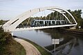
Pont du Moulin over the Escaut
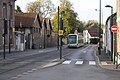
Tram on the edge of the city center


Town twinning
-
 Ay ( France )
 -
 Bátaszék ( Hungary )
 -
 Besigheim ( Germany )
 -
 Newton Abbot ( England )
 -
 Quaregnon ( Belgium )
Personalities

- Josquin Desprez († 1521 in Condé), Franco-Flemish composer and singer
- Emmanuel Duke of Croÿ (1718–1784), Imperial Prince and Marshal of France
- Mademoiselle Clairon (1723-1803), French actress
- Adrien Bourgogne (1785–1867), French sergeant of the Napoleonic Wars
- Rachel Legrain-Trapani (* 1988), Miss France 2007
Web links
literature
- Le Patrimoine des Communes du Nord. Flohic Editions, Volume 1, Paris 2001, ISBN 2-84234-119-8 , pp. 567-573.
- Bruno Carpentier, Condé-sur-l'Escaut, Le Pagus Condatensis , Éditions Sopaic, Charleville-Mézières 2004
Individual evidence
- ^ De Nederlanden in Frankrijk, Jozef van Overstraeten, 1969
- ↑ Historical maps from Petit historique de Vieux-Condé , accessed on November 14, 2018
- ↑ a b c d e f g h i j k Territoire d'histoire at www.conde59.fr, accessed on November 11, 2018
- ↑ a b Condé-sur-l'Escaut at cassini.ehess.fr, accessed on November 12, 2018
- ↑ a b c d e f g h Histoire de Condé-sur-l'Escaut at genealexis.fr, accessed on November 11, 2018
- ↑ a b Information board at the port
- ^ Th. Geilenkirchen: Basic features of the ironworks. First volume , p. 119 on Google Books
- ↑ Condé-sur-l'Escaut on the Insee website