
Ennery (Moselle)
| Ennery | ||
|---|---|---|

|
|
|
| region | Grand Est | |
| Department | Moselle | |
| Arrondissement | Metz | |
| Canton | Le Pays messin | |
| Community association | Rives de Moselle | |
| Coordinates | 49 ° 14 ' N , 6 ° 13' E | |
| height | 154-228 m | |
| surface | 7.24 km 2 | |
| Residents | 2.010 (January 1, 2017) | |
| Population density | 278 inhabitants / km 2 | |
| Post Code | 57365 | |
| INSEE code | 57193 | |
| Website | Ennery | |
 Mairie Ennery |
||

Ennery ( Lorraine Enerchen ) is a French commune with 2010 inhabitants (as of January 1, 2017) in the Moselle department in the Grand Est region (until 2015 Lorraine ). It belongs to the arrondissement of Metz .
geography
The municipality of Ennery is located on the Moselle , about halfway between Metz and Thionville at an altitude between 154 and 228 m above sea level. The municipal area covers 7.24 km². There are extensive industrial areas to the north and west of the town.
history
The place was first mentioned in 898 as Hunneriaca villa and in the early Middle Ages it was still on the German-French language border, which later shifted further north (the German name Umrich is documented for 1067 ). The Templars built a castle here, the Château d'Ennery.
1915–1918 the place bore the German name Ennerchen and 1940–1944 Hochschloß .
Population development
| year | 1962 | 1968 | 1975 | 1982 | 1990 | 1999 | 2007 | 2010 | 2015 | 2017 |
| Residents | 380 | 637 | 1,325 | 1,656 | 1,743 | 1,758 | 1,644 | 1,715 | 1,972 | 2.010 |
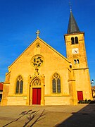
Saint-Marcel church 
Monumental wayside cross at the intersection of the roads from Metz to Thionville and from Ennery to Hauconcourt


Web links
Individual evidence
- ↑ Populations légales 2017, Commune d'Ennery 57193, (French) (accessed April 10, 2020)