
Moulins (Allier)
| Moulins | ||
|---|---|---|
.svg)
|
|
|
| region | Auvergne-Rhône-Alpes | |
| Department | Allier | |
| Arrondissement | Moulins | |
| Canton |
Moulins-1 Moulins-2 |
|
| Community association | Moulins Community | |
| Coordinates | 46 ° 34 ′ N , 3 ° 20 ′ E | |
| height | 202-240 m | |
| surface | 8.61 km 2 | |
| Residents | 19,664 (January 1, 2017) | |
| Population density | 2,284 inhabitants / km 2 | |
| Post Code | 03000 | |
| INSEE code | 03190 | |
| Website | www.ville-moulins.fr | |
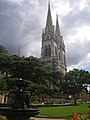
 View of Moulins |
||

_01.JPG)
Moulins is a town with 19,664 inhabitants (as of January 1, 2017) in the French region of Auvergne-Rhône-Alpes in the Allier department . It is the seat of the prefecture of the department.
Because of its long history, including as the residence of the Dukes of Bourbon , the city is called Ville d'Art et d'Histoire .
geography
The old town of Moulins is located on the right bank of the Allier , about 50 kilometers north of Vichy . The district of La Madeleine is on the left side of the Allier; the settlement area, which borders seamlessly in the east, is already part of the municipality of Yzeure .
history
Moulins experienced its golden age in the 15th century, when the dukes of Bourbon , after whom the region of the north Massif Central is still called Bourbonnais today, resided in the city on the Allier and when the nearby monasteries, especially Souvigny , became spiritual and cultural Centers next to the political center Moulins developed. The name of the city refers to the mill ships that operated on the Allier until the end of the 18th century and were responsible for transporting the grain harvests from this part of France.
Spa tourism, which around 1900 attracted more and more visitors to Auvergne , especially Vichy, passed Moulins by. The only thing left to her was political importance as the capital of the Allier department. During the German occupation in World War II , the border between occupied France and the France of the pro-German Marshal Pétain ran through the middle of Moulins, the border guards were stationed at Pont Régemortes .
Population development
| year | 1962 | 1968 | 1975 | 1982 | 1990 | 1999 | 2007 | 2016 |
|---|---|---|---|---|---|---|---|---|
| Residents | 23,909 | 25,979 | 26,067 | 25,159 | 22,799 | 21,892 | 20,251 | 19,613 |
Attractions
See also: List of Monuments historiques in Moulins (Allier)
- Notre Dame de Moulins Cathedral
- Chapelle de la Visitation with the tomb of Duke Henry II of Montmorency and ceiling paintings from the 17th century
- Tour Jacquemart
- La Mal Coiffée / Ancien Palais du Bourbon
- Museum of Anne de Beaujeu
- Bourbonnais du Moulins Museum
- Former market hall
- Rue du Pont Ginguet
- Center national du costume de scene
- Chapelle Notre-Dame , former chapel of the girls' boarding school of the Augustinian choir women (Chanoinesses de Saint-Augustin de la Congrégation Notre-Dame), today the function room of the Hôtel de Paris
- Classicist streets around the Place Marx Dormoy
Notre Dame Cathedral

Castle of the Dukes of Bourbon

Tour Jacquemart

Museum of Anne de Beaujeu
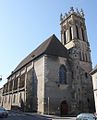
Saint-Pierre church

_Ch%C3%A2teau_des_ducs_de_Bourbon_995.jpg)


_Eglise_St_Pierre_(1).jpg)
Infrastructure
Moulins used to be on the N7 route , which today bypasses the town widely. Road traffic on the left side of the Allier only runs over the stone road bridge Pont Régemortes, which was opened in 1763 .
Moulins has had a train station on the Moret-Veneux-les-Sablons-Lyon-Perrache railway since 1853 . Furthermore, the railway lines to Montluçon (out of service) and Mâcon (in service to Paray-le-Monial ) branch off in Moulins . The railway line to Montluçon crosses the Allier on the railway bridge built in 1858 .
The station Moulins-sur-Allier is of Intercités trains on the links Paris-Bercy - Clermont-Ferrand and Nantes - Lyon-Perrache served. In regional traffic, trains of the TER Bourgogne-Franche-Comté and TER Auvergne-Rhône-Alpes run to Nevers , Dijon-Ville , Clermont-Ferrand and Lyon-Perrache.
Twin cities
- Bad Vilbel (Germany)
- Montepulciano (Italy)
- Tangier (Morocco)
Personalities
- Master von Moulins (before 1470 – after 1500), Renaissance painter
- Maria Felicia Orsini (1600–1666), Duchess of Montmorency and Superior of the Order of the Visitation of Mary
- Claude-Louis-Hector de Villars (1653–1734), general
- James Fitzjames, 1st Duke of Berwick-upon-Tweed (1670–1734), military leader and marshal
- Louis Mantin (1851–1905), builder of the Maison Mantin
- Josef Haas (1863–1929), German Romance studies and university professor
- Antoine Meillet (1866–1936), linguist of the early 20th century
- Georges Bidault (1899–1983), politician
- Robert Poujade (1928-2020), politician
- Richard Bohringer (born 1942), actor
- Angélo Tulik (* 1990), track and road cyclist
- Jules Maigret , imaginary police officer and protagonist of numerous crime novels from the pen of Georges Simenon
literature
- Le Patrimoine des Communes de l'Allier. Flohic Editions, Volume 2, Paris 1999, ISBN 2-84234-053-1 , pp. 850-901.