Westfriedhof (Nuremberg)
|
Westfriedhof
Statistical District 70 Statistical District 700 City of Nuremberg
Coordinates: 49 ° 27 '48 " N , 11 ° 2' 44" E
|
|
|---|---|
| Height : | 298-310 m above sea level NN |
| Area : | 98.43 ha |
| Residents : | 3184 (Dec. 31, 2015) |
| Population density : | 3,235 inhabitants / km² |
| Postcodes : | 90419, 90425 |
| Area code : | 0911 |
|
Location of the statistical district 70 Westfriedhof in Nuremberg
|
|
|
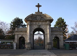
Entrance to the Westfriedhof Nuremberg
|
|
The Westfriedhof is a municipal cemetery in the west of Nuremberg between Pegnitz , Nordwestring and Schnieglinger Straße.
history
In the 19th century, Nuremberg began to grow rapidly. By 1880 Nuremberg already had around 100,000 inhabitants. The cemeteries that were available up to then became too small. Therefore, the Central Cemetery was opened on July 25, 1880 on the western outskirts of Nuremberg. In addition to the population growth and the constant death rate, the reasons for the expansion of the first municipal cemetery in Nuremberg were the low expansion possibilities of the church cemeteries. In the course of secularization , the cemetery and funeral system was sovereignly transferred from the parish offices to the municipal administration. The Westfriedhof soon had to be expanded, as a map by Gottlieb Schwarz shows in 1895. The location in the undeveloped Pegnitzaue made it possible to gradually enlarge the site from the original 16 hectares to 39 hectares and to expand the grave sites from 9,500 to around 40,000. The landscape architecture design of the Westfriedhof is based on the concept of the English landscape garden and corresponds to the type of the park cemetery . The main portal, built in neo-baroque style in 1878 , marks the entrance area of the cemetery complex. The morgue was built in 1884.
Since another large cemetery was built at the beginning of the 20th century with the Südfriedhof , the Central Cemetery was renamed Westfriedhof on October 11, 1904.
In 1905, the Nuremberg Israelite Community acquired a plot of land northwest of the Westfriedhof. The New Jewish Cemetery was inaugurated with the first burial on May 10, 1910. Like the Westfriedhof, the New Israelite Cemetery is laid out like a park and complements the old Jewish cemetery on Bärenschanzstrasse.
The first crematorium in Nuremberg was built according to plans by Friedrich Küfner in the direct vicinity of the Westfriedhof, at today's address at Schnieglinger Strasse 147. The first cremation took place here on May 19, 1913.
The Mourning Noris , a bronze monument by Philipp Kittler, was placed in the cemetery in 1923.
The Westfriedhof gave the statistical district 70 its name. The actual cemetery, as District 700, forms the southwestern part of the district. District 701 Bielefelder Straße covers the area northeast of the cemetery.
| Neighboring statistical districts | |||||||||
|---|---|---|---|---|---|---|---|---|---|
|
Web links
- District data sheet Nuremberg - Statistical District 70 Westfriedhof , as of 2015 (PDF; approx. 120 kB)
- Charlotte Bühl : Westfriedhof . In: Michael Diefenbacher , Rudolf Endres (Hrsg.): Stadtlexikon Nürnberg . 2nd, improved edition. W. Tümmels Verlag, Nuremberg 2000, ISBN 3-921590-69-8 ( complete edition online ).
Individual evidence
- ^ City of Nuremberg, Office for Urban Research and Statistics for Nuremberg and Fürth (ed.): Statistical Yearbook of the City of Nuremberg 2016 . December 2015, ISSN 0944-1514 , 18 Statistical City Districts and Districts, p. 244–245 , p. 245 ( nuernberg.de [PDF; 6.3 MB ; accessed on November 1, 2017]).
- ^ Historical development of the Nuremberg cemeteries. City of Nuremberg, cemetery administration, accessed on November 19, 2014 .
- ↑ a b c d Theo Friedrich: From the Hesperidengarten to the Volkspark: Garden culture and urban green maintenance from the Middle Ages to the present in Nuremberg . 1st edition. Edelmann Verlag, Nuremberg 1993, ISBN 978-3-87191-181-1 , p. 41 .
- ^ Gottlieb Schwarz: Plan der Stadt Nürnberg, 1895. Retrieved on November 19, 2014 .
- ↑ On the history of the crematoria. City of Nuremberg, cemetery administration, accessed on November 19, 2014 .
- ^ City map service Nuremberg


