
Wasserburg am Inn district
| coat of arms | Germany map | |
|---|---|---|

|
Coordinates: 48 ° 4 ' N , 12 ° 14' E |
|
| Basic data (as of 1972) | ||
| State : | Bavaria | |
| Administrative region : | Upper Bavaria | |
| Administrative headquarters : | Wasserburg a.Inn | |
| Area : | 651.15 km 2 | |
| Residents: | 52,670 (1970) | |
| Population density : | 81 inhabitants per km 2 | |
| License plate : | WS | |
| Circle key : | 09 1 54 | |
| Circle structure: | 62 parishes | |
| District Administrator : | Josef Bauer ( CSU ) | |
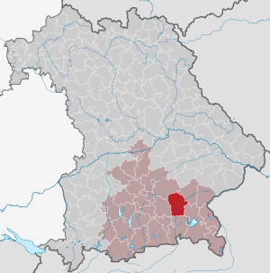
| Location of the district of Wasserburg a.Inn in Bavaria | ||
  |
||

The district of Wasserburg am Inn , officially the district of Wasserburg a.Inn, existed until 1972. It belonged to the Bavarian administrative district of Upper Bavaria .
geography
location
The district comprised the historical areas of the former county of Haag , organized as a Bavarian district court since 1838 and expanded with the Freising parts of the Erding district court and the Wasserburg district court.
Area and population
The district of Wasserburg had an area of around 651.15 square kilometers with 62 predominantly rural communities (including three market communities) with 1,352 towns, hamlets and wastelands, the population was approximately 52,700 (as of 1970).
Neighboring areas
In 1972 the district bordered in a clockwise direction in the northeast on the districts of Erding , Mühldorf am Inn , Traunstein , Rosenheim and Ebersberg .
history
district Court
The district court Wasserburg was formed in 1802 as a district court of the older order from the electoral district court Wasserburg and parts of the dissolved electoral district court Kling .
In 1852 the Kingdom of Bavaria created so-called district communities. These regulated supra-local matters, such as supra-local road construction. There was a district council for each district court.
District Office and District Court
The district office of Wasserburg was formed in 1862 through the merger of the regional courts of the older order of Haag and Wasserburg. In the area of the royal Bavarian district office Wasserburg there were two district communities Haag and Wasserburg.
The district court of Wasserburg am Inn was established in 1879, which continued to exist as a branch of the Rosenheim district court from 1972 until 2013. On the occasion of the reform of the layout of the Bavarian district offices, the Wasserburg am Inn district office ceded municipalities to the Mühldorf district office on January 1, 1880 .
In 1919 the Free State of Bavaria established the self-governing bodies known at that time as districts. The two district communities were dissolved and re-established as the Wasserburg am Inn district with a district council. There was not yet an elected district administrator. The state district administrator headed the district council.
district
On January 1, 1939, as everywhere in the German Reich , the designation district was introduced. This is how the district office became the Wasserburg am Inn district. The head of the authority was now called "District Administrator". From 1946 he was elected by the district council and from 1948 by the electorate.
The district of Wasserburg am Inn with the seat of the district office in Wasserburg am Inn was dissolved on July 1, 1972 as part of the regional reform in Bavaria :
- The city of Wasserburg am Inn and the communities Albaching , Amerang , Attel , Babensham , Edling , Eiselfing , Griesstätt , Kling, Pfaffing , Ramerberg , Rott am Inn , Schonstett and Soyen came to the district of Rosenheim .
- The communities of Gars am Inn , Haag in Upper Bavaria , Kirchdorf , Maitenbeth , Rechtmehring , Reichertsheim , Oberornau and Unterreit came to the district of Mühldorf am Inn .
- The municipality of Sankt Christoph came to the district of Ebersberg .
- The communities Isen , Mittbach , Sankt Wolfgang and Schiltern came to the district of Erding .
Population development
| year | Residents | source |
|---|---|---|
| 1864 | 32,657 | |
| 1885 | 33,727 | |
| 1900 | 36,148 | |
| 1910 | 38,581 | |
| 1925 | 39,677 | |
| 1939 | 39,151 | |
| 1950 | 54,790 | |
| 1960 | 49,000 | |
| 1971 | 53,300 |
District administrators
- 1945–1946: Josef Estermann
- 1946–1948: Hans Niedermayer
- 1948–1970: Heinrich Stulberger , Bavarian Party , his deputy was Karl Neuburger
- 1970–1972: Josef Bauer , CSU
Communities
Before the start of the Bavarian regional reform, the district comprised 62 communities in the 1960s:
License Plate
On July 1, 1956, the district was assigned the distinguishing sign WS when the vehicle registration number that is still valid today was introduced . It was issued until August 3, 1974. It has been available again in the Rosenheim district since July 10, 2013 .
literature
- Sigfrid Hofmann (Red.): City and district of Wasserburg am Inn. Past and present. Heimatbuch = Heimatbuch Stadt und Landkreis Wasserburg am Inn . Hoeppner, Pörsdorf b. Assling 1962
Individual evidence
- ^ Wilhelm Volkert (ed.): Handbook of Bavarian offices, communities and courts 1799–1980 . CH Beck, Munich 1983, ISBN 3-406-09669-7 , p. 588 .
- ^ Wilhelm Volkert (ed.): Handbook of Bavarian offices, communities and courts 1799–1980 . CH Beck, Munich 1983, ISBN 3-406-09669-7 , p. 97 .
- ^ Federal Statistical Office (ed.): Historical municipality directory for the Federal Republic of Germany. Name, border and key number changes in municipalities, counties and administrative districts from May 27, 1970 to December 31, 1982 . W. Kohlhammer, Stuttgart / Mainz 1983, ISBN 3-17-003263-1 , p. 594 f .
- ^ Ordinance on the reorganization of Bavaria into rural districts and independent cities of December 27, 1971
- ^ Eugen Hartmann: Statistics of the Kingdom of Bavaria . Ed .: Royal Bavarian Statistical Bureau. Munich 1866, population figures of the district offices 1864 ( digitized version ).
- ↑ Royal Bavarian Statistical Bureau (ed.): Localities directory of the Kingdom of Bavaria . Munich 1888, population figures of the district offices 1885 ( digitized ).
- ↑ a b www.gemeindeververzeichnis.de
- ^ Localities directory for the Free State of Bavaria, based on the census of June 16, 1925
- ↑ Statistical Yearbook for the German Reich 1940
- ↑ Statistical Yearbook for the Federal Republic of Germany 1952
- ↑ Statistical Yearbook for the Federal Republic of Germany 1961
- ↑ Statistical Yearbook for the Federal Republic of Germany 1973
- ^ Official register of places for Bavaria 1964
- ↑ http://www.ovb-online.de/rosenheim/wasserburg/ws-kennzeichen-sehr-gefragt-3055365.html
Aichach | Alzenau i.UFr. | Amberg | Bad Aibling | Bad Neustadt adSaale | Bad Toelz | Beilngries | Berchtesgaden | Bow | Brückenau | Burglengenfeld | Dingolfing | Dinkelsbühl | Donauwörth | Ebermannstadt | Boars | Eggenfelden | Erlangen | Eschenbach idOPf. | Feuchtwangen | Friedberg | Feet | Gemünden a.Main | Gerolzhofen | Grafenau | Griesbach i.Rottal | Gunzenhausen | Hammelburg | Hassfurt | Hersbruck | Hilpoltstein | Höchstadt adAisch | Hofheim i.UFr. | Illertissen | Ingolstadt | Karlstadt | Kaufbeuren | Kemnath | Kempten (Allgäu) | Königshofen i.Grabfeld | Kötzting | Krumbach (Swabia) | Landau adIsar | Lauf adPegnitz | Running | Lohr a.Main | Mainburg | Mallersdorf | Marktheidenfeld | Marktoberdorf | Mellrichstadt | Memmingen | Mindelheim | Münchberg | Nabburg | Naila | Neuburg adDonau | Neunburg vorm Wald | Neustadt adAisch | Nordlingen | Nuremberg | Obernburg am Main | Oberviechtach | Ochsenfurt | Parsberg | Pegnitz | Parish churches | Rehau | Riedenburg | Roding | Rothenburg ob der Tauber | Rottenburg adLaaber | Scheinfeld | Schongau | Schrobenhausen | Schwabach | Schwabmünchen | Sonthofen | Stadtsteinach | Staffelstein | Straubing | Sulzbach-Rosenberg | Uffenheim | Viechtach | Vilsbiburg | Vilshofen | Vohenstrauss | Waldmünchen | Wasserburg a.Inn | Wegscheid | Weilheim i.OB | Weißenburg i.Bay. | Wertingen | Wolfratshausen | Wolfstein
1939–1945 affiliated districts: Bergreichenstein | Eisenstein market | Prachatitz