
Hartberg
|
Borough Hartberg
|
||
|---|---|---|
| coat of arms | Austria map | |
 |
|
|
| Basic data | ||
| Country: | Austria | |
| State : | Styria | |
| Political District : | Hartberg-Fürstenfeld | |
| License plate : | HF (from 1.7.2013; old: HB) | |
| Surface: | 21.58 km² | |
| Coordinates : | 47 ° 17 ' N , 15 ° 58' E | |
| Height : | 359 m above sea level A. | |
| Residents : | 6,795 (January 1, 2020) | |
| Postal code : | 8230 | |
| Area code : | 03332 | |
| Community code : | 6 22 19 | |
| NUTS region | AT224 | |
| UN / LOCODE | AT HTA | |
| Address of the municipal administration: |
Hauptplatz 10 8230 Hartberg |
|
| Website: | ||
| politics | ||
| Mayor : | Marcus Martschitsch ( ÖVP ) | |
|
Municipal Council : (2020) (25 members) |
||
| Location of Hartberg in the Hartberg-Fürstenfeld district | ||
  |
||
 Hartberg town hall |
||
| Source: Municipal data from Statistics Austria | ||

Hartberg is a town with 6795 inhabitants (as of January 1, 2020) and is located in the federal state of Styria in the south-east of Austria . It is the administrative center of the Hartberg-Fürstenfeld district and is located in the Fürstenfeld judicial district .
geography
Hartberg is located on the eastern edge of the Styrian Joglland at the transition to the Eastern Styrian hill country . The city is located in the east of Styria and about 40 km northeast of the provincial capital Graz .
The Hartberger Safen flows through the east of the urban area . Its tributaries drain the municipality. The highest point in Hartberg is the Ringkogel (789 m) in the north-west.
In the south lies the Natura 2000 European protection area Gmoos .
Community structure
|
structure
|
||||||
|
Legend for the breakdown table
|
The main town is part of the urban area (population in brackets, as of January 1, 2020):
- Hartberg (4264) with the districts of Eggfeld, Lebing and Steinfeld
and the localities:
- Eggendorf (662) with Dumpfental, Klaffenau, Kleindörfl and Point
- Habersdorf (163)
- Ring (924) with Walleiten
- Safenau (782) with Neusafenau
In the cadastre , the urban area is made up of the cadastral communities (area 2015):
- Eggendorf (506.65 ha)
- Grazervorstadt (263.16 ha)
- Habersdorf (234.34 ha)
- Hartberg (11.30 ha)
- Ring (417.42 ha)
- Safenau (388.58 ha)
- Ungarvorstadt (336.39 ha)
Neighboring communities
| Greinbach | Greinbach | Grafendorf near Hartberg |
| Hartberg surroundings |
.svg)
|
Sankt Johann in der Haide |
| Hartberg surroundings | Book-St. Magdalena | Book-St. Magdalena |
history
The area around Hartberg was already settled in prehistoric times, as evidenced by a Neolithic settlement on the nearby Ringkogel. In the Hallstatt and Latène times there was a fortified Celtic hilltop settlement on the Ringkogel . There are also traces of settlement from Roman times , such as Villa Rustica ; Remains of Roman buildings from the second century were also found under the parish church of Hartberg and the rectory.
Hartberg was laid out and expanded according to plan from 1125 to 1128 by Margrave Leopold I von Steyr . In 1286 the settlement was first mentioned as a city. The town remained in sovereign possession until 1529, before it was sold to the then governor Siegmund von Dietrichstein .
In 1469 the city was conquered by rebels under the imperial mercenary leader Andreas Baumkircher , and a few years later it was devastated by the soldiers of the Hungarian King Matthias Corvinus . In 1532, Turkish troops passed the city, but destroyed the suburbs. In 1605 the Haiducken besieged Hartberg unsuccessfully; even then the suburbs were again sacked.
In 1715 the city burned down except for a few houses.
In 1944, during the time of National Socialism , a resistance group was formed in Hartberg around the Wehrmacht deserter Gustav Pfeiler, which hid in the mountains and was sometimes voluntarily supported by farmers in the area with food and accommodation. In March 1945 the approximately 40 members of the group became militarily active. So they were able to blow up three Fieseler Fi 156 planes and tried to arrest the Hartberg local group leader Erich Heumann. They shot members of his family and seriously wounded him. As a result, more and more people joined the group, on the other hand, the SS used more and more men to persecute the group and arrested numerous farmers in the area who were suspected of supporting the partisans . On May 4, 1945, after a stand trial in the city park, nine freedom fighters were shot and four others were hanged in the main square. When the Red Army approached on May 7, 1945 , SS units took other partisan sympathizers with them on their retreat and shot them on the way. These executions or murders claimed a total of 27 lives.
In 1946, a memorial plaque for this group was placed on the Reckturm in the city park. A memorial stone in the cemetery bears the unspecific inscription “In memory of the victims of the last days of the war in 1945”. The graves of the resistance fighters were also adapted to those of the Wehrmacht soldiers.


Population development

The population increased continuously from 1869 to 2001, with particularly strong growth between 1869 and 1880 (+ 13.1%), 1880 to 1890 (+ 12.1%), 1900 to 1910 (again + 12.1% while it in the previous decade it was only 2.0%) and from 1939 to 1953 (+21.2%). Only from 1923 to 1934 was there a decrease of 1.6%. The number of inhabitants has remained almost constant since 2001, the negative birth balance is offset by a positive migration balance.
Religions
Hartberg's residents are predominantly Roman Catholic (88.2%). The second largest religious community is the Evangelical Church with 2.9%, closely followed by Islam with 2.6%. Other religions reach less than 1%. 4.1% are without religious belief.
In addition to a Roman Catholic, Hartberg has also been the seat of a Protestant parish since 1948.
Culture and sights


- theatre
There are two theater groups in Hartberg. These are the Liebhaberbühne Hartberg, which interprets folk works, mainly comedies, and the triBühne Hartberg, which has performed very demanding pieces and the like over the past twenty years. A. von Shakespeare , Felix Mitterer , Friedrich Dürrenmatt and Johann Nestroy played. The last piece was Das Fest by Thomas Vinterberg .
The Hartberghalle serves as the primary venue for both groups .
- Museums
- city Museum
- Buildings

Hartberger Karner
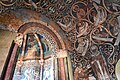
Inside view of the Karner

The interior of the church

Horizontal tower
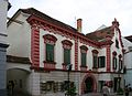
Old town house in the pedestrian zone

The pharmacy at the main square

Memorial plaque for the resistance fighters


- The late Romanesque Hartberger Karner with frescoes dates from the 12th century.
- The late Gothic parish church of St. Martin is mentioned for the first time in 1157 and expanded in baroque style from 1745 to 1760 . The high altar sheet comes from Johann Cyriak Hackhofer .
- Hartberg Castle is a medieval castle from the 12th century. In the 16th century it was redesigned in the Renaissance style, in the 17th century the arcade wing was built. The castle complex is used today by the cosmetics manufacturer and multilevel marketing company Ringana, which has its administrative headquarters here. Exceptions are a catering business in the former horse stable and the knight's hall, which is still used for public events.

- City wall:
- Remains of the city wall date from the 12th to 13th centuries. It runs from the Reckturm , which was built in the second half of the 13th century, over the terraced city park to Hartberg Castle to the north, along the ring further east to Franz-Schmidt-Gasse . In the east, the Schölbingerturm with a short remnant of the city wall is preserved. Below the parish church and Karner, the steep step was part of the church fortress in the narrow belt of the original city wall. The two city gates were demolished in the 19th century.
- Capuchin Church and Monastery :
- The construction of the Capuchin monastery lasted from 1654 to 1658 and was completed with the consecration of the church. After the monks were expropriated at the time of National Socialism, the building was converted into a nursing home, which it remained until 1955. A part of today's monastery is the company headquarters as well as an education and event center.
- The ring control room was built in 1906 and is the lookout tower on the Ringkogel.
- The Roman Catholic pilgrimage church Maria Lebing in the parish of Hartberg is dedicated to the completion of Mary (Assumption).
economy
A good half (51%) of the resident companies are active in the service sector (especially personal, social and public services); over a third of the companies (37.3%) are trading companies . There are also technical service companies, construction companies and production companies in the fields of metal processing , textiles and carpets, plastics (production of spectacle frames) and food and beverages . Tourism also plays an increasing role in summer .
traffic
Hartberg is located on the south A 2 motorway and thus on the main traffic artery from Vienna to Graz . The city is also crossed by the Wechsel Strasse B 54 from Wiener Neustadt to Gleisdorf , which has lost its national importance since the completion of the Süd Autobahn. The city is also the starting point for Burgenland Straße B 50, which leads via Oberwart to the Hungarian border in the direction of Szombathely .
The Thermenbahn connects Hartberg by rail with Vienna , Graz (via Fehring ) and Fürstenfeld with regional trains every two hours ; Compared to the southern runway, however, the route is only of minor importance. The train station in Hartberg , according to the stations Furstenfeld and Friedberg 's third largest railway station in the district.
The Graz Airport is around 75 km away and Vienna International Airport around 140 km away.
media
The district-wide published week - HBZ, the Hartberger Bezirkszeitung , as well as the Kleine Zeitung are represented by a regional office in Hartberg. Radio Hartberg , a regional web radio, was online from 2007 to December 2010 .
Sports

The resident gymnastics and sports club (TSV) consists of the sections women's gymnastics , men's gymnastics , judo , karate , athletics , modern gymnastics , chess , skiing as well as the member clubs youth sports, tennis , HCH ( ice hockey ) which is now part of a team from Switzerland Hartberg-Weiz merged "balloon sport, soccer and volleyball .
The club TSV Hartberg (football section) has been playing in the Bundesliga , the highest Austrian level , since the 2018/19 season .
TSV Hartberg (volleyball section) currently plays with the women's team in the Austrian volleyball league , with the men's team currently in the second-highest division. The men's team is a four-time European Cup participant and was Austrian Volleyball Cup winner in 2007 and 2013, the women's team has already taken part in the European Cup three times.
The resident ice hockey club (HC Hartberg, also a member of TSV) was the champion of the 2007/08 season in the Styrian national league.
In addition to the TSV, there are numerous other clubs in Hartberg. Among other things, the curling club ESV Flugrad Hartberg and the ice hockey club Naughty Dogs .
The Hartberg archery club (BSC Edelweiss Hartberg) is also at the forefront in Austria and around the world. This club in Hartberg has existed for more than 20 years and has won countless titles during this time. A total of 455 medals have been won since 1984. Of these, 211 were gold, 139 silver and 105 bronze medals. Every year an international tournament or an Austrian state championship is held in Hartberg. There are training opportunities in Habersdorf in summer and in the training hall of HSVU Edelweiss Hartberg in winter.
Public facilities
As the district capital, Hartberg is the regional center and thus the seat of offices, authorities and other public institutions.
- City Hall
- District Commission
- Tax office
- Land surveying office
- Police inspection
- District offices of the chambers of agriculture and forestry, workers and salaried employees and the chamber of commerce
- Labor market service
- State hospital
education
Hartberg acts as a school town for the area. There are two elementary schools and two new middle schools in the city that focus on sports, computer science and music. In addition, the Hartberg Gymnasium includes a Gymnasium , a Realgymnasium, an Upper Level Realgymnasium in the same school center, there is also a Federal Training Institute for Kindergarten Pedagogy, a Higher Education Institute for Business Professions, a Technical School for Agriculture and Food Management Hartberg, a Home Economics School, a Federal Commercial Academy and Federal Commercial School . There is also a special education center and a music school. A private school, which is made up of a primary and secondary school and is located in the Hartberg Ecopark, is also located in the city of Hartberg.
Hiking trails
The long-distance hiking trail 07 leads through the urban area of Hartberg, which in this section runs parallel to the Styrian state circular hiking trail 950.
The local hiking trail no. 1 (marked blue and white) leads around the city, here are other local hiking trails, such as path variants to the ring station.
politics
The city council has a total of 25 members.
| Political party | 2015 | 2010 | 2005 | 2000 | 1995 | 1990 | ||||||||||||
|---|---|---|---|---|---|---|---|---|---|---|---|---|---|---|---|---|---|---|
| St. | % | M. | St. | % | M. | St. | % | M. | St. | % | M. | St. | % | M. | St. | % | M. | |
| ÖVP | 1601 | 42 | 11 | 1927 | 49 | 12 | 2107 | 54 | 14th | 2066 | 53 | 14th | 2249 | 56 | 15th | 2262 | 55 | 14th |
| SPÖ | 870 | 23 | 6th | 1078 | 27 | 7th | 1059 | 27 | 7th | 870 | 22nd | 5 | 640 | 16 | 4th | 840 | 20th | 5 |
| FPÖ | 492 | 13 | 3 | 324 | 8th | 2 | 343 | 9 | 2 | 589 | 15th | 4th | 687 | 17th | 4th | 508 | 12 | 3 |
| The green | 639 | 17th | 4th | 631 | 16 | 4th | 407 | 10 | 2 | 372 | 10 | 2 | 370 | 9 | 2 | 507 | 12 | 3 |
| NEOS | 196 | 5 | 1 | not running | not running | not running | not running | not running | ||||||||||
| LIF | not running | not running | not running | not running | 91 | 2 | 0 | not running | ||||||||||
| Eligible voters | 5,302 | 5,378 | 5,269 | 4,942 | ||||||||||||||
| voter turnout | 73% | 75% | 76% | 80% | 85% | 91% | ||||||||||||
- mayor
- 2004–2016 Karl Pack (ÖVP)
- since 2016 Marcus Martschitsch (ÖVP)
Municipal council
The municipal council consists of 25 members and is composed as follows according to the results of the municipal council election on March 22, 2015 :
- 11 mandates ÖVP
- 6 mandates SPÖ
- 3 FPÖ mandates
- 4 mandates The Greens
- 1 NEOS mandate
In order to secure the municipal council majority, the ÖVP formed a coalition with the SPÖ. In March 2016, a group of four ÖVP councilors left the ÖVP council club. They remained as free mandataries on the municipal council. A local council from this group resigned in October 2016. The successor to the ÖVP's list was again a member of the ÖVP municipal council club.
In July 2015, an FPÖ local council resigned from its party membership and has been a member of the ÖVP local council club since 2016.
In January 2017, the SPÖ terminated the coalition agreement with the ÖVP.
In April 2017, the SPÖ, the Greens, the FPÖ and the three “free” ÖVP mandataries formed a coalition called the “Future Pact for Hartberg”, which has a majority with 15 mandates. The mayor continues to be provided by the ÖVP, as a two-thirds majority is required to be voted out.
In October 2017, the only NEOS municipal council resigned from its mandate for professional reasons. No successor could be found in the list for the vacant seat. As of November 20, 2017, only 24 of the 25 municipal council seats have been occupied by municipal councils. Nine of them are part of the ÖVP, 15 are part of the “Future Pact for Hartberg”.
coat of arms
Blazon : "In a red shield crossed by a silver bar, the figure of Saint Martin appears on a green ground, sitting on a brown, gray-bridled horse striding to the left."
His head with a full white beard is covered with a pointed brown hat adorned with an ermine cuff and surrounded with a golden halo. His clothing consists of a red doublet, a pair of trousers, a green, yellow-lined coat and brown, hermel-covered boots.
The saint turns to a white-haired and white-bearded beggar kneeling next to the horse on his right knee and striving up his right hand, who is only wrapped in a brown cloak and a gray apron. The shield is surrounded by an ornamented steel-colored border.
Personalities
Honorary citizen
- 1961: Tobias Udier (1911–1985), Deputy Governor
- 1971: Franz Wegart (1918–2009), Deputy Governor
sons and daughters of the town
- Margret Almer (* 1962), yodeler and popular singer
- Karin Ammerer (* 1976), children's book author
- Christian Falk (* 1987), soccer player
- Rudolf Gigler (* 1950), writer
- Siegfried Herrmann (* 1942), politician
- Josef Knar (1800–1864), mathematician and university professor
- Werner Kogler (* 1961), politician (Greens)
- Erna Lesky (1911–1986), medical historian
- Martin Löschberger (* 1957), actor
- Laurenz Pansipp (1752–1827), master stonemason
- Alois Rechberger (1935–2009), politician
- Daniela Riedl (* 1982), artist and musician
- Othmar Rieger (1904–1966), Germanist, teacher and poet
- Regina Sackl (* 1959), ski racer
- Sha. (* 1972), artist
- Wolfgang Waldl (* 1989), soccer player
People related to the city
- Philip Wilhelm von Hornick (1640–1714), parish administrator from 1668 to 1672 in Hartberg
- Matthias Macher (1793–1876), Austrian physician and writer, lived in Hartberg from 1829 to 1850
- Fritz Ries (1907–1977), German industrialist, set up a carpet factory in Hartberg in the early 1970s
- Ludwig Hirsch (1946–2011), songwriter and actor
- Friedrich Schöpfer (1825–1903), lawyer and self-taught artist
- Ernst Vasovec (1917–1993), writer, lived in Hartberg from 1949 to 1964
Others
Hartberg has been a member of Cittàslow since 2009 , a movement founded in Italy in 1999 to slow down and improve the quality of life in cities.
literature
- Stephan Stibor: Hartberg 1918–1938. A study on politics, culture, economy and society of a region. Dissertation. University of Graz, Graz 2010. - Full text online (PDF) .
- Josef Strauss, Christian Handl (photo): Hartberg, a city through the ages. Heimat-Verlag, Schwarzach 2003, ISBN 3-9501643-8-3 .
- Rudolf Grotti: German Nationalism in Hartberg 1918–1938. IGULV documentation, ZDB -ID 2369467-1 . IGULV - interest group comprehensive national defense, Hartberg 1995. (Also: diploma thesis, University of Graz, Graz 1994).
- Alois Kernbauer, Fritz Huber: 700 years of Civitas Hartberg. Sources and contributions to city history . 2nd Edition. Hartberger writings on history. Historical Association, Hartberg 1987.
Web links
- 62219 - Hartberg. Community data, Statistics Austria .
- City of Hartberg
Individual evidence
- ↑ Local council election 2020 - Hartberg results. orf.at , accessed on August 22, 2020 .
- ↑ Statistics Austria: Population on January 1st, 2020 by locality (area status on January 1st, 2020) , ( CSV )
- ↑ Heimo Halbrainer: Memento for partisans in Styria . In: DÖW (ed.): Yearbook 2009: Focus on armed resistance - resistance in the military . Lit Verlag, Vienna 2009, ISBN 978-3-643-50010-6 , p. 213, 220–222 ( chapter online on the DÖW website (PDF; 3.15 MB)).
- ↑ Memorial plaque for resistance fighters. In: www.generationendialog-steiermark.at. Retrieved November 23, 2017 .
- ↑ Fritz Molden : The fire in the night . Amalthea, Vienna / Munich 1988, ISBN 3-85002-262-5 , p. 224 .
- ↑ A look at the Hartberg community. (PDF; 41.6 kB) Political district: Hartberg-Fürstenfeld / Federal state: Styria. In: Statistics Austria . May 14, 2020 .
- ^ Woisetschläger, Krenn: Dehio Steiermark (excluding Graz). P. 161.
- ^ Hartberg: Search for a new mayor. In: orf.at . June 7, 2016, accessed July 5, 2020 .
- ↑ Harald Hofer: Future Pact: These municipal councils now have the majority. In: kleinezeitung.at. April 21, 2017, accessed July 5, 2020 (subscription).
- ↑ Harald Hofer: Hartberg: Farewell to the municipal council. In: mein district.at. October 17, 2017, accessed July 5, 2020 .
- ^ History of the city of Hartberg. In: mein district.at. Retrieved July 5, 2020 .
- ↑ Südost-Tagespost (December 14, 1961), p. 5.
- ↑ Südost-Tagespost (May 16, 1971), p. 5.
- ↑ Laurenz Pansipp. In: RegiowikiAT. Retrieved July 5, 2020 .
- ↑ Cittá Slow - The Alliance of Liveable Cities. In: hartberg.at. Retrieved July 5, 2020 .
.svg)
Bad Blumau | Bad Loipersdorf | Bad Waltersdorf | Book-St. Magdalena | Burgau | Dechantskirchen | Ebersdorf | Feistritztal | Friedberg | Fürstenfeld | Grafendorf near Hartberg | Greinbach | Großsteinbach | Großwilfersdorf | Hartberg | Hartberg surroundings | Hartl | Ilz | Kaindorf | Lafnitz | Neudau | Ottendorf an der Rittschein | Pinggau | Pöllau | Pöllauberg | Rohr bei Hartberg | Rohrbach an der Lafnitz | Sankt Jakob im Walde | Sankt Johann in der Haide | Sankt Lorenzen am Wechsel | Shepherds | Söchau | Stubenberg | Advance | Waldbach-Mönichwald | Wenigzell