Staunton, Virginia
| Staunton | ||
|---|---|---|
 Downtown of Staunton |
||
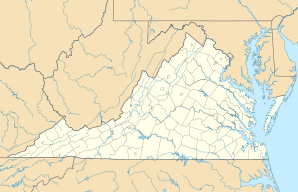
| Location in Virginia | ||
|
|
||
| Basic data | ||
| Foundation : | 1747 | |
| State : | United States | |
| State : | Virginia | |
| Coordinates : | 38 ° 9 ′ N , 79 ° 5 ′ W | |
| Time zone : | Eastern ( UTC − 5 / −4 ) | |
|
Inhabitants : - Metropolitan Area : |
24,363 (as of 2016) 121,247 (as of 2016) |
|
| Population density : | 478 inhabitants per km 2 | |
| Area : | 51.0 km 2 (approx. 20 mi²) of which 51.0 km 2 (approx. 20 mi²) are land |
|
| Height : | 432 m | |
| Postcodes : | 24401, 24402 | |
| Area code : | +1 540 | |
| FIPS : | 51-75216 | |
| GNIS ID : | 1500154 | |
| Website : | www.staunton.va.us | |
| Mayor : | Lacy B. King | |
Staunton ([ stɛntən ]) is an independent city in the US -amerikanischen State Virginia . In 2016 there were 24,363 residents here.
Nearby are the Natural Chimneys, unusual limestone caves that rise 40 meters above the meadow landscape of the Shenandoah Valley.
Population development
| year | Inhabitants¹ |
|---|---|
| 1980 | 21,857 |
| 1990 | 24,461 |
| 2000 | 23,853 |
| 2010 | 23,746 |
| 2016 | 24,363 |
¹ 1980–2010: census results; 2016: Update of the US Census Bureau
sons and daughters of the town
- John E. Colhoun (1749-1802), US Senator
- Joseph Calhoun (1750-1817), politician
- John Brown (1757-1837), US Senator
- John Breckinridge (1760–1806), lawyer and politician
- Thomas Wilson (1765–1826), politician
- James Brown (1766–1835), politician (Democratic Republican Party)
- Parry Wayne Humphreys (1778-1839), politician
- James Coffield Mitchell (1786–1843), politician
- Robert Wilson (1803-1870), politician
- Alexander Hugh Holmes Stuart (1807-1891), US Secretary of the Interior
- John Brown Baldwin (1820–1873), lawyer, politician and officer
- Jacob C. Davis (1820-1883), politician
- Samuel Augustus Merritt (1827-1910), politician
- Joseph W. Fifer (1840–1938), politician
- James William Marshall (1844-1911), politician
- Jacob Yost (1853–1933), politician
- Woodrow Wilson (1856–1924), 28th President of the United States of America
- Hugh Ike Shott (1866-1953), politician
- Eugene L. Opie (1873-1971), pathologist and microbiologist
- William Haines (1900–1973), actor
- William M. Bass (* 1928), anthropologist
- Francis Collins (* 1950), head of the human genome project
Web links
Commons : Staunton, Virginia - Collection of pictures, videos, and audio files
