
Bak
| coat of arms | Germany map | |
|---|---|---|

|
Coordinates: 53 ° 43 ' N , 10 ° 47' E |
|
| Basic data | ||
| State : | Schleswig-Holstein | |
| Circle : | Duchy of Lauenburg | |
| Office : | Lauenburg lakes | |
| Height : | 41 m above sea level NHN | |
| Area : | 4.3 km 2 | |
| Residents: | 886 (Dec. 31, 2019) | |
| Population density : | 206 inhabitants per km 2 | |
| Postal code : | 23909 | |
| Area code : | 04541 | |
| License plate : | RZ | |
| Community key : | 01 0 53 004 | |
| Office administration address: | Fünfhausen 1 23909 Ratzeburg |
|
| Website : | ||
| Mayor : | Thomas Teut ( CDU ) | |
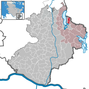
| Location of the municipality of Bäk in the Duchy of Lauenburg | ||
  |
||


Bäk is a municipality in the Duchy of Lauenburg in Schleswig-Holstein . It is located on the east bank of the Ratzeburg Lake in the Lauenburg Lakes Nature Park . Bäk has no other districts.
geography
The three-kilometer-long brook Bäk , where the village is located, overcomes a difference in altitude of around 27 meters between Lake Mechower and Lake Ratzeburg. In the community there is also a forest area of around 100 hectares, the Mechower Holz .
history
The Bach Bäk and its gradient made it possible to operate copper hammers or copper mills at at least five barrages in the so-called Kupfermühlental in the early modern times . The workers' settlement for the mills located on the Bäk was founded in 1581, from where the Bäk also got its nickname Hungry Bäk, because the people there worked for a starvation wage.
The former Mecklenburg community was transferred from the Soviet occupation zone to the British in 1945 through the exchange of territory based on the Barber-Lyaschtschenko Agreement and thus became part of Schleswig-Holstein. The reorganization of the leases on Mecklenburg official reserve land, which was initially administered in trust by the state of Schleswig-Holstein and later by the federal government, dragged on until the 1960s, amid difficult negotiations.
politics
Community representation
Of the eleven seats in the municipal council, the CDU has nine seats since the 2018 local elections and the BWG voter community has two seats.
coat of arms
Blazon : "Divided by silver and red. Above on the dividing line a blue mill wheel above, below a floating, silver Latin cross, above a golden crown."
The coat of arms was approved in 1981. The half mill wheel refers to the water-powered copper hammers that were operated in Bäk in the 16th and 17th centuries. The silver Latin cross with the golden crown is reminiscent of the Ratzeburg diocese (later part of Mecklenburg-Strelitz as the Principality of Ratzeburg ) to which the place once belonged.
Economy and Infrastructure
With the death of the mills in the course of industrialization, the economic structure of the village changed and it began to develop into a residential community.
Since Bäk does not have its own schools, educational offers are mainly used in the nearby Ratzeburg .
Attractions
The list of cultural monuments in Bäk includes the cultural monuments entered in the list of monuments of Schleswig-Holstein.
Web links
Individual evidence
- ↑ North Statistics Office - Population of the municipalities in Schleswig-Holstein 4th quarter 2019 (XLSX file) (update based on the 2011 census) ( help on this ).
- ↑ Aasbüttel - Bordesholm . In: Wolfgang Henze (ed.): Schleswig-Holstein topography: cities and villages of the country . 1st edition. tape 1 . Flying-Kiwi-Verl. Junge, Flensburg 2001, ISBN 3-926055-58-8 , p. 175 .
- ↑ Klaus von der Groeben: The Mecklenburg property assets in the communities of Ziethen, Mechow, Bäk and Römnitz. History of the change of area and the trust management since 1945. Bonn-Bad Godesberg: Klassenausgleichsbank [1982], pp. 85–96
- ↑ Schleswig-Holstein's municipal coat of arms
Albsfelde | Alt-Mölln | Aumühle | Bäk | Blue | Basedow | Basthorst | Behlendorf | Berkenthin | Besenthal | Bliestorf | Exchanges | Borstorf | Breitenfelde | Bröthen | Brunsmark | Brunstorf | Books | Buchholz | Buchhorst | Dahmker | Dalldorf | Dassendorf | Düchelsdorf | Duvensee | Single house | Elmenhorst | Escheburg | Fitzen | Fredeburg | Fuhlenhagen | Geesthacht | Giesensdorf | Göldenitz | Goddess | Grabau | Grambek | Grinau | Big floor | Great Disnack | Groß Grönau | Great Pampau | Great Sarau | Groß Schenkenberg | Grove | Gudow | Gülzow | Bream | Hamfelde | Hamwarde | Harmsdorf | Havekost | Hohenhorn | Hollenbek | Hornbek | Horst | Juliusburg | Kankelau | Kasseburg | Kastorf | Kittlitz | Klein Pampau | Klein reveler | Plumbing | Klinkrade | Koberg | Kollow | Koethel | Kröppelshagen-Fahrendorf | Krukow | Curved mass | Krüzen | Kuddewörde | Killing | Kulpin | Labenz | Langenlehsten | Lankau | Lance | Lauenburg / Elbe | Clay wheel | Linau | Lüchow | Lütau | Mechow | Möhnsen | Mölln | Mill wheel | Must | Mustin | Niendorf ad St. | Niendorf near Berkenthin | Nuts | Panting | Pogeez | Poggensee | Ratzeburg | Ritzerau | Römnitz | Rondeshagen | Roseburg | Sahms | Salem | Sandesneben | Schiphorst | Schmilau | Schnakenbek | Schoenberg | Schretstaken | Schulendorf | Poking soles | Schwarzenbek | Seedorf | Seven trees | Seven oaks | Sierksrade | Sirksfelde | Steinhorst | Sterley | Stump | Talkau | Tramm | Walksfelde | Wangelau | Wentorf (Amt Sandesneben) | Wentorf near Hamburg | Wiershop | Witzeeze | Wohltorf | Woltersdorf | Worth | Ziethen
Community-free area in the Duchy of Lauenburg
Sachsenwald district