
Böel
| coat of arms | Germany map | |
|---|---|---|

|
Coordinates: 54 ° 39 ' N , 9 ° 43' E |
|
| Basic data | ||
| State : | Schleswig-Holstein | |
| Circle : | Schleswig-Flensburg | |
| Office : | Süderbrarup | |
| Height : | 21 m above sea level NHN | |
| Area : | 13.66 km 2 | |
| Residents: | 702 (Dec. 31, 2019) | |
| Population density : | 51 inhabitants per km 2 | |
| Postcodes : | 24401, 24405, 24891 | |
| Primaries : | 04641, 04646 | |
| License plate : | SL | |
| Community key : | 01 0 59 006 | |
| LOCODE : | DE 5B7 | |
| Office administration address: | Königstrasse 5 24392 Süderbrarup |
|
| Website : | ||
| Mayor : | Rainer Stahmer (FWG) | |
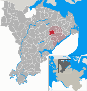
| Location of the municipality of Böel in the Schleswig-Flensburg district | ||
  |
||

Böel ( Danish : Bøl ) is a municipality in the Schleswig-Flensburg district in Schleswig-Holstein . It was created by merging Böel and Böelschuby (Danish: Bøl and Bøl Skovby ).

Community structure
The community is divided into the following districts and places:
- Postal code 24401: Billmoor, Billwatt (Danish: Bilvad ), Böel ( Bøl ), Böelkamp, Böelschuby ( Bøl Skovby ), Böelschubyhof ( Bølskovbygaard ), Böelschubymühle, Böelstamm, Böelulegermarkraff ( Ulvegrav ), Lehmlschauberg ( Høelwesterfeld ), Bøelwesterfeld ( Bøelwesterfeld ) ( Lerbjerg ), Möllmoos ( Møllemose ), Neuböelschuby ( Ny Bøl Skovby )
- Postal code 24405: Borrieshaag, Böelnorderfeld ( Bølnørremark ), Stoltoft, Thiesholz ( Tisholt )
- Postal code 24891: Dingwatt ( Tingvad ), Rabenholzlück ( Ravnholtløkke )
history
Böel was first mentioned in 1231 as Böla ( Bølæ ). At times the names Boel or Bohl were used. The name comes from the Old Danish boeli (Old Norse: ból , New Danish bøl , possibly Old Norse býli ) for settlement, residence, homestead .
The late Romanesque brick church St. Ursula Church was built in the first third of the 13th century. The tower with the octagonal tent roof was added in the 15th century. Christian I transferred the church to the Mohrkircher Antoniter monastery in 1477 , which was dissolved after the Reformation in Schleswig-Holstein in 1544. The church formed the center of the parish of Böel ( Bøl Sogn ).
In 1478 Gut Böelschubyhof was first mentioned as Bole Schowby . The present mansion, which is surrounded by an irregularly rectangular moat, was built in 1864.
In the 19th century, the language change from Danish to German took place in Angling , as a result of which Angel Danish, which had been widespread until then, gradually disappeared as a colloquial language. The sole school and church language was High German for a long time. With the language rescripts valid from 1851 to the German-Danish War in 1864, the Danish government finally tried to slow down the change of language. The rescripts stipulated that in the parts of southern Schleswig where both German and Danish had been widespread, Danish should replace German as the school language. The church language should alternate between German and Danish. The Oxbek brook, running south of Böel, formed the border to the area with still purely German school and church language. Many residents felt that the rescripts were compulsory. It is recorded from Böel that many parents at that time did not register their children in the Böel elementary school, but on the south side in order to be able to avoid the Danish school language.
On January 1, 1974, the municipality Böelschuby was incorporated.
politics
Community representation
Of the eleven seats in the municipal council has Wählergemeinschaft FWG since the local elections in 2013 six seats and the CDU five.
coat of arms
Blazon : “Split by a blue and gold wave pole of gold and green. On the right a green winged cross of a windmill, on the left a golden linden fruit stand. "
Economy and Infrastructure
The place is predominantly agricultural, but also has many residential areas.
Attractions
Personalities
- Christian Hieronymus Esmarch (1752–1820), member of the Göttingen Hainbund , comes from Böel
- Jobst von Berg (* 1962), German artist, lives and works in Böel
- Hans-Jörg Detlefsen (* 1963), flotilla admiral
Web links
Individual evidence
- ↑ North Statistics Office - Population of the municipalities in Schleswig-Holstein 4th quarter 2019 (XLSX file) (update based on the 2011 census) ( help on this ).
- ^ Municipality of Böel in the genealogical directory of places (Mohrkirchmühle, however, belongs to Mohrkirch)
- ^ M. Mørk Hansen, CL Nielsen: Kirkelig Statistics on Slesvig Stift: Med historiske og topographiske Bemarkninger. Volume 2, Kjøbenhavn 1864, p. 384
- ↑ Wolfgang Laur: Historisches Ortsnamelexikon von Schleswig-Holstein , 2nd edition, Neumünster 1992, p. 161
- ↑ Johannes Kok: Det danske folkesprog i Sønderjylland , Volume 2, Copenhagen 1867, p. 106
- ↑ Ursula Church Böel ( Memento of the original from March 3, 2011 in the Internet Archive ) Info: The archive link was automatically inserted and not yet checked. Please check the original and archive link according to the instructions and then remove this notice.
- ↑ Grænseforeningen: 1851 Sprogreskripter
- ^ Homepage of the municipality of Böel ; Retrieved on: July 26, 2017
- ^ National development in the 19th century. The Danish Movement in Southern Schleswig , accessed on: July 26, 2017
- ^ Frank Jung: 1864. The war for Schleswig-Holstein , 2014
- ^ Federal Statistical Office (ed.): Historical municipality directory for the Federal Republic of Germany. Name, border and key number changes in municipalities, counties and administrative districts from May 27, 1970 to December 31, 1982 . W. Kohlhammer, Stuttgart / Mainz 1983, ISBN 3-17-003263-1 , p. 184 .
- ↑ Schleswig-Holstein's municipal coat of arms
Ahneby | Alt Bennebek | Arnis | Ausacker | Bergenhusen | Böel | Böklund | Bollingstedt | Bores | Borgwedel | Börm | Böxlund | Brodersby-Goltoft | Busdorf | Dannewerk | Dollerup | Dbodstedt | Eggebek | Ellingstedt | Invent | Esgrus | Fahrdorf | Free will | Gelting | Geltorf | Glücksburg (Baltic Sea) | Grödersby | Great Rheide | Großewiehe | Large voltage | Grundhof | Handewitt | Harrislee | Hasselberg | Havetoft | Hollingstedt | Holt | Hörup | Hürup | Husby | Hüsby | Idstedt | Jagel | Janneby | Jardelund | Jerrishoe | Jörl | Jübek | Kappeln | Folded wood | Klein Bennebek | Klein Rheide | Kronsgaard | Kropp | Long-crowned | Langstedt | Lindewitt | Loit | Lottorf | Lürschau | Maasbüll | Maasholm | Medelby | Meggerdorf | Meyn | Middle fishing | Mohrkirch | Munkbrarup | Neuberend | Nieby | Sneeze gray | Norderbrarup | Nordhackstedt | Nottfeld | Nübel | Oersberg | Oeversee | Osterby | Pommerby | Rabel | Raven wood | Rabenkirchen-Faulück | Ringsberg | Rügge | Saustrup | Schaalby | Schafflund | Scheggerott | Schleswig | Schnarup-Thumby | Schuby | Selk | Sieverstedt | Silberstedt | Sollerup | Soerup | Hatchback | Stack | Steinberg | Steinberg Church | Steinfeld | Sterup | Proud | Stoltebüll | Struxdorf | Süderbrarup | Süderfahrenstedt | Süderhackstedt | Taarstedt | Tarp | Tastrup | Tetenhusen | Tielen | Tolk | Treia | Twedt | Uelsby | Ulsnis | Wagersrott | Wallsbull | Wanderup | Wees | Weesby | Westerholz | Wohlde