
Gouttières (Puy-de-Dôme)
|
Gouttières Goutira |
||
|---|---|---|
.svg)
|
|
|
| region | Auvergne-Rhône-Alpes | |
| Department | Puy-de-Dôme | |
| Arrondissement | Riom | |
| Canton | Saint-Éloy-les-Mines | |
| Community association | Pays de Saint-Éloy | |
| Coordinates | 46 ° 4 ′ N , 2 ° 46 ′ E | |
| height | 591-803 m | |
| surface | 25.63 km 2 | |
| Residents | 342 (January 1, 2017) | |
| Population density | 13 inhabitants / km 2 | |
| Post Code | 63390 | |
| INSEE code | 63171 | |
| Website | http://www.gouttieres63.fr/ | |
_mairie.JPG) Gouttières Town Hall |
||

Gouttières is a French municipality with 342 inhabitants (at January 1, 2017) in the department of Puy-de-Dôme in the region Auvergne Rhône-Alpes (before 2016 Auvergne ). The municipality belongs to the arrondissement of Riom and the canton of Saint-Éloy-les-Mines (until 2015 Saint-Gervais-d'Auvergne ).
location
Gouttières is about 30 kilometers northwest of Riom and about 45 kilometers northwest of Clermont-Ferrand . Gouttières is surrounded by the neighboring communities of Le Quartier in the north, Teilhet in the north and northeast, Sainte-Christine in the east, Saint-Gervais-d'Auvergne in the southeast, Saint-Priest-des-Champs in the south, and Saint-Julien-la-Geneste in the west and south-west, Saint-Maigner in the west and La Cellette in the north-west.
Population development
| year | 1962 | 1968 | 1975 | 1982 | 1990 | 1999 | 2006 | 2013 |
| Residents | 572 | 538 | 463 | 381 | 381 | 386 | 368 | 357 |
| Source: Cassini and INSEE | ||||||||
Attractions
- Saint-Pierre church
- Notre-Dame-des-Blés chapel
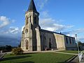
Saint-Pierre church

Notre-Dame-des-Blés chapel

