
Grünberg (Hesse)
| coat of arms | Germany map | |
|---|---|---|

|
Coordinates: 50 ° 35 ' N , 8 ° 58' E |
|
| Basic data | ||
| State : | Hesse | |
| Administrative region : | to water | |
| County : | to water | |
| Height : | 264 m above sea level NHN | |
| Area : | 89.24 km 2 | |
| Residents: | 13,612 (Dec 31, 2019) | |
| Population density : | 153 inhabitants per km 2 | |
| Postal code : | 35305 | |
| Primaries : | 06401, 06400 (Klein-Eichen, Lardenbach, Stockhausen, Weickartshain), 06408 (Harbach), 06634 (Weitershain) | |
| License plate : | GI | |
| Community key : | 06 5 31 006 | |
| LOCODE : | DE GRU | |
| City structure: | 14 districts | |
City administration address : |
Rabegasse 1 35305 Grünberg |
|
| Website : | ||
| Mayor : | Frank Ide ( FWG ) | |
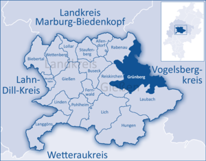
| Location of the city of Grünberg in the district of Gießen | ||
  |
||

Grünberg is a small town in the central Hessian district of Gießen . The city is a state-recognized health resort .
geography
A tiny part of the northwestern Vogelsberg lies in the Grünberg district. The Äschersbach flows through the municipality from north to south.
Neighboring communities
| Rabenau (GI) | Homberg (Ohm) (VB) | Mosquito (VB) |
| Reiskirchen (GI) |
.svg)
|
Ulrichstein (VB) |
| Laubach (GI) |
VB = Vogelsbergkreis GI = District of Giessen
City structure

Grünberg is a city with approx. 13,500 inhabitants, which consists of a core city and 13 other districts. The city districts include:
Beltershain , Göbelnrod , Grünberg, Harbach , Klein-Eichen , Lardenbach , Lehnheim , Lumda , Queckborn , Reinhardshain , Stangenrod , Stockhausen , Weickartshain and Weitershain .
history
middle Ages


At the end of the 12th century, Landgrave Ludwig III founded von Thuringia Grünberg to protect his property in the south against the hostile Archbishops of Mainz . It is located on a plateau that slopes steeply on three sides: strategically very favorable. In 1186 Grünberg Castle ( Castrum Gruninberc ) is mentioned for the first time in a document. Grünberg was first mentioned as a city in 1222 .
In 1195 troops from Mainz destroyed the facility. The castle was quickly rebuilt and a larger, surrounding city was planned from the outset. As early as 1222, the court of the city of Grünberg issued documents and used a seal similar to that of the landgrave .
The landgrave's castle was located within the city wall near the steep southern slope. The civil suburbs followed suit. The monasteries were in the relatively unprotected north. If someone wanted to attack the city, they should have destroyed it first. However, this inevitably led to the excommunication .
The Antoniterkloster Grünberg ( Lage → ), founded around 1193, was one of the oldest and most important. Around 1200 it was still a simple monastery with an integrated hospital, but its strategically favorable position not far from two main traffic routes meant that over time it developed into a General Preceptory of the Antonite Order . With the founding of his subsidiaries, his area reached in its greatest extent from Friedberg in Hesse to the Nonneseter monastery in Bergen (Norway) and from Wetzlar to Lennewarden in what is now Latvia . The first of these branches was founded on June 7, 1222 in Tempzin near Wismar .
A little later, the Franciscans also settled in Grünberg.

Grünberg was a mint as early as 1230 . In 1254, Grünberg joined the " Rheinische Städtebund " ( Rhenish Association of Cities ) together with today much larger towns like Marburg and Alsfeld .
On October 16, 1272, the Hessian Landgrave Heinrich I issued the Grünbergers a letter of freedom, which confirmed their urban rights . He granted freedom of movement to all citizens and made them subject to direct jurisdiction.
The city grew. At the end of the 13th century, the Gothic St. Mary's Church was built, based on the Elisabeth Church in Marburg . The new town in front of the city wall is mentioned for the first time in 1304. In 1324 a new defensive wall was built , which also enclosed the Neustadt. In 1353 the city inaugurated the first school.
Citizen industry was certainly a root of the city's wealth. More important, however, was the location on one of the major trade routes from Frankfurt am Main to Central Germany : the short Hessen or the Hohe Strasse . Two large pillages devastated almost the entire city in 1370 and 1391. With the support of the landgrave, the reconstruction proceeded very quickly. However, Grünberg did not regain its old importance.
Nevertheless, the city had a central water supply set up in 1419 , for which the most modern technology was used at the time. Spring water was mechanically pumped up the mountain from the 60 m deep well valley. Emperor Friedrich III. In 1481 the city founded an annual market , the Gallusmarkt , which was supposed to last eight days. It was placed on October 16, Gallus Day , to commemorate the day the city received the Letter of Freedom in 1272. The Gallusmarkt is celebrated every year to this day.
From the beginning, the city administration was in the hands of a council of twelve mostly wealthy men. As early as 1305, however, he had a dispute with the rest of the citizenry over questions of finances. As a result, a compromise was negotiated on June 5, by virtue of which the citizens should from now on also send twelve men from their ranks to the council. In 1482 this body was limited to four men. The city constitution was preserved in this form until the 19th century.
Historical forms of names
In historical documents of the city over the centuries with varying spelling of the place name is (in brackets the year of reference): Gruninberc (1186), Grunenberg (1194), Gruninberc (1222), Grunberc (1258) Gruenberg (1343) Grunenburg (1364) and Grunbergk (1591).
Modern times


Grünberg also became Lutheran between 1524 and 1527 , and Landgrave Philip of Hesse dissolved the monasteries . From 1578 to 1582 he had the Antonite monastery converted into a widow's residence (today's “castle”) by Ebert Baldewein . Among other things, it received two beautiful Renaissance bay windows. The land was given to the state university. The Augustinian convent became the city's hospital - (The city history museum and the ethnographic Theo Koch-Grünberg collection opened in this building in October 2005. ) At the same time, the city hired two more teachers for the school, and the girls were now also receiving elementary education .
The university building, built in 1526, is Upper Hesse's highest timber-framed building. During the plague epidemic in 1542, the University of Marburg was moved to the building.
When the country was divided in 1567, Grünberg came to Hessen-Marburg , and in 1604 to Hessen-Darmstadt .
In 1593 there were 432 full citizens living in the city; after the Thirty Years' War and a plague epidemic , there were only 220 left. At that time, the city council had over 100 empty houses demolished.
The city recovered only slowly. Since the political and economic centers had also shifted, Grünberg developed into an agricultural town , as is typical for Upper Hesse. The cemetery church, a baroque building from the early 18th century, shows this clearly. When the Gothic church collapsed in 1816, the city could not begin with the new building until 1846. During this time, wise policy had resulted in the debt halving within 20 years.

The statistical-topographical-historical description of the Grand Duchy of Hesse reports on Grünberg in 1830:
“Grünberg (L. Bez. Gl. N.) city; is located on a hill, 5 hours east of Giessen, on the Chaussee from Giessen to Alsfeld, as well as on the road that goes from here to Friedberg. The city is surrounded by a wall, which is provided with a parapet, and has with the 2 suburbs, namely the new town and the courtyards, 387 houses and 2542 inhabitants, who are Protestant apart from 2 Catholics, and is the seat of the district administrator, des District court, the rent office, the tax commissioner and a secondary customs office. You will find 1 old castle, 1 church, called the hospital church, the large town church is in ruins, 1 hospital, 1 town hall, 1 school building, 1 brewery, 1 well house, 1 guard house, 2 prison towers, 5 meal, 1 oil, and Lohmühle, 1 brickworks, 1 post office and 1 pharmacy. Then belongs here, the stone path, consisting of 7 houses and a fountain art, which adjoins the city, and the control room, which is 1305 Hess, (1004 par.) Feet above the sea. The old castle, which is state property, serves partly as the seat of the regional court and the rent office and partly it is uninhabited. In the old town church there were various monuments, some of which were destroyed a few years ago by the collapse of the church. The two main squares are the market and the Grohl. On the first stand the beautiful town hall and 5 inns. The bridge in the direction of Alsfeld deserves special mention, through which two mountains are connected and which is characterized by its extraordinary vault, which is covered high with earth. Last summer, when a garden was lifted to build a pharmacy, 6-8 feet deep, layers of burned wheat and grain were discovered, just as fire rubble is often found inside and outside the city, digging. There are 27 civil servants and 24 peasants among the population, and the rest of them belong to the trade and industry. The wool factories that supply shawls and flannels were otherwise more important than now. Most of the flannels are still made and sold abroad. There are 3–4 master clothiers, as well as 10–12 linen weavers, who fabricate the linen wall, which is particularly blue and white striped. Some wool and linen dye-works produce good goods. Rothgerber has Grünberg 4 and just as many white tanners, who especially prepare sheep leather and bring them to the Frankfurt trade fairs. Among the other trades there are the shoemakers, of whom there are 120 masters here, then the bakers, butchers, joiners, stocking weavers, tailors, white-makers, bricklayers, glaziers, locksmiths, blacksmiths, coppersmiths, tinsmiths, etc. Markets are held 6 a year, of which the third and last shopkeeper, but the rest are cattle and shopkeepers at the same time. The Gallusmarkt, which is very popular, is particularly well known. Incidentally, weekly markets are held every Saturday, which are very important. The soil of the district is heavy and fertile, and the cultivation of the fields is carried out with such diligence that nothing remains undeveloped in the extraordinarily large district. The main field products are wheat, grain, barley, oats, potatoes, less heather and poppy seeds. Meadow cultivation is good, but a lot of red and white clover is still being extracted, which greatly benefits cattle breeding. There are many quarries in the area that provide stones suitable for building roads, and there are also clay pits and iron stones. The city forest holds just over 1500 acres. - In 1186 Landgrave Ludwig III. built a castle here to protect the landgraves' possessions from the area against the Mainz residents, and this gave rise to Grünberg. But already in 1195, in the war between the archbishops of Mainz and Kölln against Landgrave Hermann, Grünberg was captured and completely destroyed. However, the place must have been rebuilt very soon; for as early as 1227 Grünberg appeared as a city, which in 1263 was assigned to the ore monastery of Mainz as a fief, and in 1272 the citizens received from Landgrave Heinrich I the privilege that they should not be brought before any foreign courts. The Antoniter House (Tönges House), which is mentioned for the first time in 1242, and existed until 1527, when Landgrave Philipp left the property to his newly built university, was probably founded here in the 12th century. In addition to this religious house, Grünberg had a monastery for Franciscans and one for Augustinian virgins, the latter probably being a colony of Wirberg. In 1272 the city had a pastor. So it was already back then that of the Heil. Mary and the holy. Georg in the old town, and since 1369 there has been a church in the new town. Paul consecrated church, which was also staffed with its own pastor. In front of the city was a church, after which holy. Peter, and a hospital, after the healed. Elizabeth, called, both of whom were dependent on the Antonite house. In the Thirty Years' War Grünberg had to endure a lot of hardships. The high bell tower, a venerable monument of antiquity, collapsed on March 20, 1816, on itself. "
Only in the advancing 19th century did Grünberg regain its old importance. From 1832 to 1874 Grünberg was the district town . Now the economic basis was no longer the location on an important trade route, but the local crafts , especially weavers and shoemakers . In 1869 Grünberg was connected to the railroad network ( Vogelsbergbahn ) and the first textile manufacturers settled here at the end of the 19th century .
Urban construction projects were particularly a modern water supply with house connections in 1896 and a power grid that left electric lights on in 1913 . In the following decades, other municipal facilities such as school buildings and a swimming pool were built . The building structure was largely preserved, only two bomb attacks in 1945 destroyed numerous buildings and killed 150 residents.
Since over 800 refugees and displaced persons had to be integrated into the community after the war , living space was created as quickly as possible. Industrial companies were soon added. Since 1969 the old town of Grünberg with its half-timbered houses has been extensively renovated. Today it is a residential and shopping area on the green mountain, with a closed cityscape. In 1980 Grünberg was the venue for the Hessentag . Grünberg has been a state-approved climatic health resort since 1983 . As early as 1845, the grammar school teacher and chronicler Dr. Carl Glaser: “The air in our city is clean. We haven't known about epidemics for years. Here in Grünberg the air is rough but warm. "
As part of the regional reform in Hesse , 13 previously independent municipalities and current districts were incorporated into Grünberg on a voluntary basis:
- December 31, 1970: Beltershain, Göbelnrod, Klein-Eichen, Lumda, Queckborn, Stangenrod, Stockhausen, Weickhartshain and Weitershain
- February 1, 1971: Harbach and Lardenbach
- December 31, 1971: Lehnheim (until then in the district of Alsfeld )
- April 1, 1972: Reinhardshain
Since 2007 the city has had its own museum, the Museum im Spital , which reports on the history of Grünberg and shows an exhibition on the life and work of its most famous citizen, the ethnologist Theodor Koch-Grünberg (1872–1924).
Territorial history and administration
The following list gives an overview of the territories in which Grünberg was located and the administrative units to which it was subordinate:
- from 1269: Holy Roman Empire , Landgraviate of Hesse , Grünberg office
- from 1567: Holy Roman Empire, Landgraviate Hessen-Marburg , Grünberg office
- 1604–1648: Holy Roman Empire, disputed between Landgraviate Hessen-Darmstadt and Landgraviate Hessen-Kassel ( Hessian War )
- from 1604: Holy Roman Empire, Landgraviate Hesse-Darmstadt, Upper Duchy of Hesse , Amt Grünberg
- from 1806: Grand Duchy of Hesse , Upper Duchy of Hesse, Amt Grünberg
- from 1815: German Confederation , Grand Duchy of Hesse, Province of Upper Hesse , Grünberg Office
- from 1821: German Confederation, Grand Duchy of Hesse, Province of Upper Hesse, District District Grünberg (separation between justice ( District Court Grünberg ) and administration)
- from 1832: German Confederation, Grand Duchy of Hesse, Province of Upper Hesse, Grünberg district
- from 1848: German Confederation, Grand Duchy of Hesse, Gießen district
- from 1852: German Confederation, Grand Duchy of Hesse, Province of Upper Hesse, Grünberg district
- from 1867: North German Confederation , Grand Duchy of Hesse, Province of Upper Hesse, District of Grünberg
- from 1871: German Empire , Grand Duchy of Hesse, Province of Upper Hesse, District of Grünberg
- from 1874: German Empire, Grand Duchy of Hesse, Province of Upper Hesse, District of Gießen
- from 1918: German Empire, People's State of Hesse , Province of Upper Hesse, District of Gießen
- from 1945: American zone of occupation , Greater Hesse , Darmstadt administrative district, Gießen district
- from 1949: Federal Republic of Germany , State of Hesse , Darmstadt administrative district, Gießen district
- from 1977: Federal Republic of Germany, State of Hesse, Darmstadt administrative district, Lahn-Dill district
- from 1979: Federal Republic of Germany, State of Hesse, Darmstadt district, Gießen district
- from 1981: Federal Republic of Germany, State of Hesse, Gießen district, Gießen district
Law
Substantive law
In Grünberg, the town and official custom of Grünberg was a particular right . The Common Law was only included if the office I do not need regulations. This special law of old tradition retained its validity during the affiliation to the Grand Duchy of Hesse in the 19th century, until it was replaced on January 1, 1900 by the civil code that was uniformly valid throughout the German Empire .
Court constitution since 1803
In the Landgraviate of Hesse-Darmstadt , the judicial system was reorganized in an executive order of December 9, 1803. The “Hofgericht Gießen” was set up as a court of second instance for the province of Upper Hesse . The jurisdiction of the first instance was carried out by the offices or landlords and thus the “Amt Grünberg” was responsible for Grünberg. The court court was the second instance court for normal civil disputes, and the first instance for civil family law cases and criminal cases. The superior court of appeal in Darmstadt was superordinate .
With the establishment of the Grand Duchy of Hesse in 1806, this function was retained, while the tasks of the first instance were transferred to the newly created regional courts in 1821 as part of the separation of jurisdiction and administration. “ Landgericht Grünberg ” was therefore the name of the court of first instance that was responsible for Grünberg from 1821 to 1879.
On the occasion of the introduction of the Courts Constitution Act with effect from October 1, 1879, as a result of which the previous grand-ducal Hessian regional courts were replaced by local courts in the same place, while the newly created regional courts now functioned as higher courts, the name was changed to "Amtsgericht Grünberg" and assigned to the district of the regional court of Giessen . With effect from January 1, 1882, Ermenrod was assigned to the Alsfeld district court. On July 1, 1968, the Grünberg District Court was dissolved, and Grünberg was added to the Giessen District Court . In the Federal Republic of Germany, the superordinate instances are the Regional Court of Giessen , the Higher Regional Court of Frankfurt am Main and the Federal Court of Justice as the last instance.
population
Population structure
According to the 2011 census , there were 13,759 residents in Grünberg on May 9, 2011. Among them were 427 (3.1%) foreigners, of whom 158 came from outside the EU , 161 from other European countries and 108 from other countries. Of the German residents, 15.4% had a migration background . The inhabitants lived in 5782 households. 1665 of them were single households , 1718 couples without children and 1777 couples with children, as well as 468 single parents and 154 shared apartments .
Population development
Source: Historical local dictionary
| • 1577: | 420 house seats |
| • 1630: | 390 men (318 over 30 years old, 72 under 30 years old), 62 widows, 30 guardians |
| • 1677: | 342 house seats, 25 of them free |
| • 1742: | 17 clergymen / civil servants, 508 subjects, 103 young men, 4 inmates / Jews |
| • 1791: | 2088 inhabitants |
| • 1800: | 2090 inhabitants |
| • 1806: | 2092 inhabitants, 373 houses |
| • 1829: | 2542 inhabitants, 387 houses |
| • 1867: | 2248 inhabitants, 349 inhabited buildings |
| • 1875: | 2245 inhabitants, 346 inhabited buildings |
| Grünberg: Population figures from 1791 to 2015 | ||||
|---|---|---|---|---|
| year | Residents | |||
| 1791 | 2,088 | |||
| 1800 | 2,090 | |||
| 1806 | 2,092 | |||
| 1829 | 2,542 | |||
| 1834 | 2,415 | |||
| 1840 | 2,494 | |||
| 1846 | 2,635 | |||
| 1852 | 2,456 | |||
| 1858 | 2,306 | |||
| 1864 | 2,267 | |||
| 1871 | 2,221 | |||
| 1875 | 2,245 | |||
| 1885 | 2.149 | |||
| 1895 | 2,032 | |||
| 1905 | 2.164 | |||
| 1910 | 2.223 | |||
| 1925 | 2,170 | |||
| 1939 | 2,403 | |||
| 1946 | 3,318 | |||
| 1950 | 3,550 | |||
| 1956 | 3.711 | |||
| 1961 | 3,915 | |||
| 1967 | 4,320 | |||
| 1970 | 11,054 | |||
| 1972 | 11,157 | |||
| 1975 | 11,270 | |||
| 1980 | 11,187 | |||
| 1985 | 11,471 | |||
| 1990 | 12,797 | |||
| 1995 | 13,784 | |||
| 2000 | 14,233 | |||
| 2005 | 14,252 | |||
| 2010 | 13,885 | |||
| 2011 | 13,759 | |||
| 2015 | 13,634 | |||
| Data source: Historical municipality register for Hesse: The population of the municipalities 1834 to 1967. Wiesbaden: Hessisches Statistisches Landesamt, 1968. Further sources: 1972 :; from 1975 :; 2011 census From 1970 including the towns incorporated into Hesse as part of the regional reform . | ||||
Religious affiliation
| • 1830: | 2540 Protestant and 2 Roman Catholic residents |
| • 1961: | 2943 Protestant, 798 Roman Catholic residents |
| • 2011: | 8840 Protestant (= 64.7%), 1740 Catholic (= 12.7%), 500 free church (= 3.7%), 380 non-believers (= 2.8%), 2140 other (= 15.6%) residents |
Gainful employment
| • 1961: | Labor force: 172 agriculture and forestry, 776 prod. Trade, 328 trade, transport and communication, 425 services and others. |
politics


City Council
The local elections on March 6, 2016 produced the following results, compared to previous local elections:
| Parties and constituencies |
% 2016 |
Seats 2016 |
% 2011 |
Seats 2011 |
% 2006 |
Seats 2006 |
% 2001 |
Seats 2001 |
||
|---|---|---|---|---|---|---|---|---|---|---|
| FW | Free community of voters in Grünberg | 35.6 | 13 | 31.3 | 12 | 28.4 | 10 | 15.0 | 6th | |
| CDU | Christian Democratic Union of Germany | 24.9 | 9 | 27.0 | 10 | 31.1 | 12 | 41.0 | 15th | |
| SPD | Social Democratic Party of Germany | 22.2 | 8th | 23.6 | 9 | 26.3 | 10 | 32.4 | 12 | |
| GREEN | Alliance 90 / The Greens | 10.7 | 4th | 14.4 | 5 | 9.4 | 3 | 6.8 | 2 | |
| FDP | Free Democratic Party | 6.5 | 3 | 3.2 | 1 | 4.8 | 2 | 4.8 | 2 | |
| LEFT | The left | - | - | 0.5 | 0 | - | - | - | - | |
| total | 100.0 | 37 | 100.0 | 37 | 100.0 | 37 | 100.0 | 37 | ||
| Voter turnout in% | 50.9 | 47.8 | 47.1 | 54.7 | ||||||
mayor
Frank Ide (FWG) was elected on September 27, 2009 in the first ballot with 65.3% of the vote and a voter turnout of 73.9%. He is thus entering the second legislative period. The opposing candidate Birgit Otto (CDU) received 14.7% of the vote, and the SPD chairman Tobias Lux received 20.0% of the vote. In the mayoral election on June 14, 2015, the incumbent ran unopposed and was confirmed in office with 71.8%. The turnout was 36.4%. The new term of office begins on December 2, 2015 and lasts for six years.
Twin cities
Culture and sights


education
- Theo-Koch-Schule Grünberg - Integrated comprehensive school with high school and all-day courses
- Elementary school am Diebsturm, Grünberg
- Elementary school Sonnenberg, Grünberg-Stangenrod
- Gallus School Grünberg
- Grünberg horticultural training center
Cultural monuments
In the old town of Grünberg there are many half-timbered buildings with beautiful house facades (mainly 15th century) as well as numerous other important historical buildings, squares and structures. Particularly noteworthy there are:
- Market square with town hall and fountain: The market square is the center of the old town of Grünberg. The most important building on it is the town hall , a Renaissance building from 1586/87. It was built by the bailiff Hermann Rüdiger from Hersfeld. It has been owned by the city since 1593. There used to be a market and trading room in the hall on the ground floor. An iron cubit can be seen at the entrance. The fountain on the market with "Brunnengucker" is a 36 m deep drawing well, which was in operation until 1500. It was backfilled and forgotten in 1820, and rediscovered in 1980.
- Diebsturm : The Diebsturm is the landmark of the city of Grünberg and was built around 1300 as part of the city fortifications (height 25 m). Later it served as a prison for some time. In 1895/95 it was converted into a water tower. Nowadays it houses an exhibition on the history of the city fortifications and is a lookout tower .
- Barfüßerkloster (Franciscan monastery): 1272, from 1528 the buildings fell into disrepair due to the departure of the monks, only the monks' house remained, which stands directly on the city wall and is now used for cultural purposes
- Castle: Former Antonite monastery
- University building: Upper Hesse's highest half-timbered house, built around 1500, temporarily served as the administration building of the university bailiff, is also called the "Stammlersches Haus"
- Winter square with brewery (18th century) and lion fountain: the former brewery now houses the city library and the city wedding room
- Evangelical town church : built 1846-1853, in place of St. Mary's Church, which collapsed in 1816
- Female teardrop: a replica of the so-called female teardrop (grave sculpture by Samuel Nahl) is located on the south side of the Evangelical City Church
- Friedrich Gottlieb Welcker's birthplace
- Alte Schmiede, Judengasse: old, fully equipped blacksmith's workshop
- House of Guilds: houses exhibits on historical craft trades
- Theo Koch's birthplace
- Museum in the hospital , Augustinian convent; Hospital Church : Exhibition on the history of the city and the life of Theo Koch
- Brunnental: Former center of water supply, today a local recreation area with two ponds and the water wheel of the last conveyor system, well house from 1582 with an exhibition on water supply in the Middle Ages
- Dingstühle: former place of jurisdiction, today memorial for those who participated in the war in 1870/71
- Grünberger Warte (guard tower, probably 12th century): advanced defensive post in front of the old city wall. The approximately 11.7 m high tower now serves as a lookout tower
- Höfetränke: There was a small settlement here outside the city wall early on
Natural monuments
Economy and Infrastructure
Land use
The municipality covers a total area of 8924 hectares, of which in hectares are:
| Type of use | 2011 | 2015 | |
|---|---|---|---|
| Building and open space | 514 | 519 | |
| from that | Living | 282 | 290 |
| Business | 39 | 43 | |
| Operating area | 18th | 18th | |
| from that | Mining land | 0 | 0 |
| Recreation area | 45 | 55 | |
| from that | Green area | 24 | 26th |
| traffic area | 595 | 597 | |
| Agricultural area | 4840 | 4813 | |
| from that | moor | 0 | 0 |
| pagan | 0 | 0 | |
| Forest area | 2806 | 2804 | |
| Water surface | 65 | 76 | |
| Other use | 41 | 41 | |
traffic
Grünberg has a junction with the A 5 . There are stops of the Vogelsbergbahn in the districts of Grünberg, Göbelnrod and Lehnheim . The city center also has its own city bus system, called "De kleene Grimmicher", which consists of the two VGO lines 71 and 72.
Personalities
sons and daughters of the town
- Joachim Struppius (1530-1606), Physicus and personal physician in the service of the elector Ludwig VI. from the Electoral Palatinate
- Caspar Reinhard (around 1540–1623), hydraulic engineer who, among other things, renewed the water art in Marburg Castle
- Hartmann Samuel Hoffmann von Löwenfeld (1653–1709), ennobled General Field Sergeant of the Imperial Army
- Johann Meyer (1752–1830), manufacturer and politician, member of the 2nd Chamber of the Estates of the Grand Duchy of Hesse
- Friedrich Gottlieb Welcker (1784–1868), classical philologist, professor of Greek literature and archeology in Gießen , Göttingen and Bonn , founder and director of the university library in Bonn and friend of Wilhelm von Humboldt
- August Stammler (1789–1852), Hessian district administrator and member of parliament
- Wilhelm Goldmann (1792–1873), Hessian administrative officer and member of parliament
- Georg Adam Dickel (1818–1894), German-American businessman, founder of the "George Dickel" whiskey distillery
- Gustav Baist (1824–1914), Protestant pastor, founder of several Raiffeisenkassen in Franconia
- Otto Zöckler (1833–1906), Protestant theologian, professor in Greifswald , founder of the Giessen Wingolf . His father Konrad Zöckler was rector and dean in Grünberg.
- Karl Eckstein (1859–1939), forest scientist and entomologist
- Theodor Koch-Grünberg (1872–1924), ethnologist who researched in Brazil and died. The Grünberg comprehensive school is named after him.
- Wilhelm Peppler (1884–1961), meteorologist
- Richard Herrmann (1895–1941), sports functionary and major general of the Waffen SS
- Ernst Nebhut (1898–1974), writer, librettist and screenwriter
- Otto Hartmann (1899 – after 1933), politician born in Stangenrod
- Erwin Stein (1903–1992), lawyer, member of the Hessian state parliament (1946–1951), Hessian state minister for culture and education (1947–1951 also minister of justice from 1949), judge at the Federal Constitutional Court (1961–1971), honorary professor in the law department of Justus-Liebig university of Giessen
- Renate Krauß-Pötz (* 1948), designer, trade union official and management consultant
Connected with Grünberg
- Carl Geist (1870–1931), painter, lived and painted in Grünberg
- Harald Lesch (* 1960), professor of astrophysics at the Ludwig Maximilians University in Munich and professor of natural philosophy at the University of Philosophy in Munich, graduated from the Theo Koch School in Grünberg in 1978
- Alexandra Keil (* 1978) national basketball player, Bundesliga player at BC Marburg , lives in Grünberg
- Karl Steinberger (pastor in Grünberg from 1837 to 1857, honorary citizen of the city)
literature
- Waldemar Küther (arrangement): Grünberg. History and face of a city in eight centuries . Published by the municipal authorities of the city of Grünberg. Giessen 1972.
- Carl Glaser: Contributions to the history of the city of Grünberg in the Grand Duchy of Hesse. According to the city documents and other sources . Darmstadt 1846. Digitized at Google Books
- Literature on Grünberg in the Hessian Bibliography
Web links
- City of Grünberg. In: Website of the city of Grünberg. The Magistrate of the City of Grünberg, accessed on October 5, 2011 .
- Grünberg, District of Giessen. Historical local dictionary for Hessen. (As of September 14, 2017). In: Landesgeschichtliches Informationssystem Hessen (LAGIS).
- Atlas folder Grünberg. Hessian city atlas. (Status: February 2005). In: Landesgeschichtliches Informationssystem Hessen (LAGIS).
- Information on the community of Grünberg. In: Hessisches Gemeindelexikon. HA Hessen Agentur GmbH , 2016.
Remarks
- ↑ Not a member of any public religious community.
Individual evidence
- ↑ Hessian State Statistical Office: Population status on December 31, 2019 (districts and urban districts as well as municipalities, population figures based on the 2011 census) ( help ).
- ↑ 78th meeting of the specialist committee for health resorts, recreational areas and healing fountains in Hesse on November 15, 2012 . In: State pointer for the state of Hesse . No. 7 , 2013, ISSN 0724-7885 , p. 309 .
- ↑ Den katolske kirke - Norges klostre in middelalderen - Nonneseter monastery in Bergen
- ↑ a b c d e f g Grünberg, district of Gießen. Historical local lexicon for Hesse (as of February 25, 2020). In: Landesgeschichtliches Informationssystem Hessen (LAGIS). Hessian State Office for Historical Cultural Studies (HLGL), accessed in April 2020 .
- ^ A b Georg Wilhelm Justin Wagner : Statistical-topographical-historical description of the Grand Duchy of Hesse: Province of Upper Hesse . tape 3 . Carl Wilhelm Leske, Darmstadt August 1830, OCLC 312528126 , p. 105 ff . ( Online at google books ).
- ↑ Karl-Heinz Meier barley, Karl Reinhard Hinkel: Hesse. Municipalities and counties after the regional reform. A documentation . Ed .: Hessian Minister of the Interior. Bernecker, Melsungen 1977, DNB 770396321 , OCLC 180532844 , p. 294 .
- ^ Incorporation of communities into the city of Grünberg, district of Gießen from January 7, 1971 . In: The Hessian Minister of the Interior (ed.): State Gazette for the State of Hesse. 1971 No. 4 , p. 142 , point 180 ( online at the information system of the Hessian state parliament [PDF; 6.3 MB ]).
- ^ Municipal reform: mergers and integration of municipalities from January 20, 1971 . In: The Hessian Minister of the Interior (ed.): State Gazette for the State of Hesse. 1971 No. 6 , p. 248 , para. 16 ( online at the information system of the Hessian state parliament [PDF; 6.2 MB ]).
- ^ Michael Rademacher: German administrative history from the unification of the empire in 1871 to the reunification in 1990. State of Hesse. (Online material for the dissertation, Osnabrück 2006).
- ^ Grand Ducal Central Office for State Statistics (ed.): Contributions to the statistics of the Grand Duchy of Hesse . tape 13 . G. Jonghause's Hofbuchhandlung, Darmstadt 1872, DNB 013163434 , OCLC 162730471 , p. 12 ff . ( Online at google books ).
- ^ The affiliation of the Grebenau office based on maps from the Historical Atlas of Hesse : Hessen-Marburg 1567–1604 . , Hessen-Kassel and Hessen-Darmstadt 1604–1638 . and Hessen-Darmstadt 1567–1866 .
- ^ Grand Ducal Central Office for State Statistics (ed.): Contributions to the statistics of the Grand Duchy of Hesse . tape 13 . G. Jonghause's Hofbuchhandlung, Darmstadt 1872, DNB 013163434 , OCLC 162730471 , p. 13 ff ., § 26 point d) III. ( Online at google books ).
- ↑ Wilhelm von der Nahmer: Handbuch des Rheinischen Particular-Rechts: Development of the territorial and constitutional relations of the German states on both banks of the Rhine: from the first beginning of the French Revolution up to the most recent times . tape 3 . Sauerländer, Frankfurt am Main 1832, OCLC 165696316 , p. 8 ( online at google books ).
- ↑ a b Hessen-Darmstadt state and address calendar 1806 . In the publishing house of the Invaliden-Anstalt, Darmstadt 1806, p. 254 ( online in the HathiTrust digital library ).
- ↑ Latest countries and ethnology. A geographical reader for all stands. Kur-Hessen, Hessen-Darmstadt and the free cities. tape 22 . Weimar 1821, p. 419 ( online at Google Books ).
- ↑ Arthur Benno Schmidt : The historical foundations of civil law in the Grand Duchy of Hesse . Curt von Münchow, Giessen 1893, p. 67, note 40 and p. 103.
- ^ Ordinance on the implementation of the German Courts Constitution Act and the Introductory Act to the Courts Constitution Act of May 14, 1879 . In: Grand Duke of Hesse and the Rhine (ed.): Grand Ducal Hessian Government Gazette. 1879 no. 15 , p. 197–211 ( online at the information system of the Hessian state parliament [PDF; 17.8 MB ]).
- ↑ Second law amending the Court Organization Act (Amends GVBl. II 210–16) of February 12, 1968 . In: The Hessian Minister of Justice (ed.): Law and Ordinance Gazette for the State of Hesse . 1968 No. 4 , p. 41–44 , Article 1, Paragraph 2 a) and Article 2, Paragraph 4 d) ( online at the information system of the Hessian State Parliament [PDF; 298 kB ]).
- ^ A b Population by nationality groups: Grünberg, Stadt. In: Zensus2011. Bavarian State Office for Statistics , accessed in March 2020 .
- ↑ Migration background in%: Grünberg, Stadt. In: Zensus2011. Bavarian State Office for Statistics , accessed in March 2020 .
- ^ Households by family: Grünberg, Stadt. In: Zensus2011. Bavarian State Office for Statistics , accessed in March 2020 .
- ↑ Hessen-Darmstadt state and address calendar 1791 . In the publishing house of the Invaliden-Anstalt, Darmstadt 1791, p. 196 ( online in the HathiTrust digital library ).
- ↑ Hessen-Darmstadt state and address calendar 1800 . In the publishing house of the Invaliden-Anstalt, Darmstadt 1800, p. 209 ( online in the HathiTrust digital library ).
- ↑ Housing spaces 1867 . In: Grossherzogliche Centralstelle für die Landesstatistik (Ed.): Contributions to the statistics of the Grand Duchy of Hesse . tape 13 . G. Jonghause's Hofbuchhandlung, Darmstadt 1877, DNB 013163434 , OCLC 162730484 , p. 119 ( online at google books ).
- ↑ Residential places 1875 . In: Grossherzogliche Centralstelle für die Landesstatistik (Ed.): Contributions to the statistics of the Grand Duchy of Hesse . tape 15 . G. Jonghause's Hofbuchhandlung, Darmstadt 1877, DNB 013163434 , OCLC 162730484 , p. 12 ( online at google books ).
- ^ Community data sheet : Grünberg. (PDF; 222 kB) In: Hessisches Gemeindelexikon. HA Hessen Agency GmbH
- ^ Local elections 1972; Relevant population of the municipalities on August 4, 1972 . In: The Hessian Minister of the Interior (ed.): State Gazette for the State of Hesse. 1972 No. 33 , p. 1424 , point 1025 ( online at the information system of the Hessian state parliament [PDF; 5.9 MB ]).
- ↑ a b Hessian Statistical Information System In: Statistics.Hessen.
- ^ Religious affiliation : Grünberg, Stadt. In: Zensus2011. Bavarian State Office for Statistics , accessed in March 2020 .
- ^ Result of the municipal election on March 6, 2016. Hessian State Statistical Office, accessed in April 2016 .
- ^ Hessian State Statistical Office: Result of the municipal elections on March 27, 2011
- ^ Hessian State Statistical Office: Result of the municipal elections on March 26, 2006
- ^ Result of the mayoral election in Grünberg, St. 2015. Ed. Hessisches Statistisches Landesamt.
- ↑ Tourist office Stadtverwaltung Grünberg (ed.) (2015): Historischer Rundgang Grünberg, Grünberg: punctum, without page numbers (station 5)
- ↑ Tourist office Stadtverwaltung Grünberg (ed.) (2015): Historischer Rundgang Grünberg, Grünberg: punctum, without page numbers (station 9)
- ↑ Grünberger Warte on warttuerme.de

Allendorf (Lumda) | Biebertal | Buseck | Fernwald | Casting | Grünberg | Heuchelheim an der Lahn | Hung | Langgöns | Laubach | Lich | Linden | Lollar | Pohlheim | Rabenau | Reiskirchen | Staufenberg | Wettenberg
Beltershain | Göbelnrod | Grünberg | Harbach | Small oaks | Lardenbach | Lehnheim | Lumda | Queckborn | Reinhardshain | Rod rod | Stockhausen | Weickartshain | Weitershain