
Grignols (Dordogne)
|
grignols Granhòu |
||
|---|---|---|

|
|
|
| region | Nouvelle-Aquitaine | |
| Department | Dordogne | |
| Arrondissement | Périgueux | |
| Canton | Saint-Astier | |
| Community association | Isle Vern Salembre en Périgord | |
| Coordinates | 45 ° 5 ' N , 0 ° 32' E | |
| height | 68-207 m | |
| surface | 20.41 km 2 | |
| Residents | 672 (January 1, 2017) | |
| Population density | 33 inhabitants / km 2 | |
| Post Code | 24110 | |
| INSEE code | 24205 | |
| Website | http://www.mairiedegrignols.com/ | |
_mairie.JPG) Town hall (Mairie) of Grignols |
||

Grignols ( Occitan : Granhòu ) is a French municipality with 672 inhabitants (as of January 1 2017) in the department of Dordogne in the region Nouvelle-Aquitaine ; it belongs to the Arrondissement of Périgueux and the canton of Saint-Astier . The inhabitants are called Grignolais .
geography
Grignols is located about 17 kilometers west-southwest of Périgueux in the Landais countryside . The neighboring municipalities of Grignols are Saint-Astier in the north, Montrem in the northeast, Manzac-sur-Vern in the east, Jaure and Villamblard in the south, Saint-Jean-d'Estissac in the southwest, Vallereuil in the west and southwest, Neuvic in the west and Saint -Léon-sur-l'Isle in the north-west.
Population development
| year | 1962 | 1968 | 1975 | 1982 | 1990 | 1999 | 2006 | 2013 |
| Residents | 484 | 485 | 487 | 456 | 526 | 543 | 642 | 587 |
| Source: Cassini and INSEE | ||||||||
Attractions
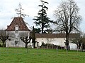
- Saint-Front church from the 15th century in Bruc
- Grignols Castle from the 14th century, monument historique since 1928
- Domain and Charterhouse of Chaulnes, built in the early 18th century
- Charterhouse of La Mothe from the 17th century

Saint-Front church

Grignols Castle
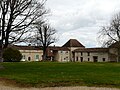
Domain of Chaulnes
Charterhouse of La Mothe
.JPG)
_ch%C3%A2teau_(2).JPG)
_domaine_Chaulnes_(4).JPG)
_la_Mothe.JPG)
Personalities
- Christian Faure (* 1954), director