
Thurnau
| coat of arms | Germany map | |
|---|---|---|

|
Coordinates: 50 ° 2 ′ N , 11 ° 24 ′ E |
|
| Basic data | ||
| State : | Bavaria | |
| Administrative region : | Upper Franconia | |
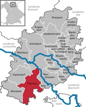
| County : | Kulmbach | |
| Height : | 363 m above sea level NHN | |
| Area : | 64.19 km 2 | |
| Residents: | 4046 (Dec. 31, 2019) | |
| Population density : | 63 inhabitants per km 2 | |
| Postal code : | 95349 | |
| Area code : | 09228 | |
| License plate : | KU, EBS , SAN | |
| Community key : | 09 4 77 157 | |
| Market structure: | 44 districts | |
Market administration address : |
Oberer Markt 28 95349 Thurnau |
|
| Website : | ||
| Mayor : | Martin Bernreuther ( CSU ) | |
| Location of the Thurnau market in the Kulmbach district | ||
  |
||

Thurnau is a market in the Upper Franconian district of Kulmbach .
location
The market is located on the northern edge of Franconian Switzerland , about 10 km from Kulmbach and 15 km from Bayreuth . The A 70 motorway crosses the municipality from east to west.
The northern 50th parallel runs along the southern parts of the municipality of Felkendorf, Kröglitzen and Leesau across the municipality.
Community structure
The political municipality of Thurnau has 44 officially named districts (the type of settlement is given in brackets ):
The deserted Buchhaus , Mühlberg , Unterwolfsknock and Weiherhaus are former districts that have since been demolished .
history

Until the church is planted
The place was first mentioned in 1137 as "Durnowa". The basic word is ouwe ( mhd. For meadow land), the defining word is probably drought (mhd. For arid, lean). Accordingly, the place name could be traced back to a field name that denotes a poor meadow landscape. Only later did the definition of tower be reinterpreted (see section coat of arms ).
Thurnau was the seat of the Förtsch ministerial family . The bishop of Bamberg had been the feudal lord since 1292. After the von Förtsch family died out in 1564, their legal successors were Hans-Georg von Giech and Hans Adam von Künsberg . In 1699 the Margraves of Bayreuth confirmed the long controversial high jurisdiction and thus the sovereignty of the country to Count Giech. In 1731 the Counts Giech bought Künsberg's share of the condominium .
Towards the end of the 18th century, Thurnau consisted of 145 properties. The Giech'sche Amt Thurnau exercised the high court and the village and community rule . Were landlords
- the Thurnau office (140 properties: 2 mills, 1 tavern, 1 estate, 2 halbsölden , 1 red tanner house, 1 bakery, 1 gatehouse, 1 house with shop, 4 houses with courtyard, 94 houses, 1 cellar house, 1 apartment, 1 residential building with Brick kiln, 2 small houses, 12 small houses, 14 farmsteads, 1 small farmstead),
- the parish of Thurnau (1 Söldengut, 2 Halbsöldengüter),
- the benefice Thurnau (2 houses).
The Thurnau office was entitled to the tax and bailiwick of the two last named landlords. In addition to the property, there were also stately buildings (2 connected castles, with a chancellery and official building, a farmhouse apartment, a case master building, a farm building and two sheep's spots with buildings. 1 church, 1 parsonage, 1 schoolhouse and 1 community forge; 1 office building and 1 bailiff of the manor Thurnau ), ecclesiastical buildings (1 church, 1 cemetery church, 1 rectory, 1 diaconate apartment) and communal buildings (1 school).
In 1796, Prussia incorporated the Thurnau rule as part of Hardenberg's policy of revision. From 1797 to 1808 it was under the Prussian Patrimonial Court of Thurnau . In the Peace of Tilsit in 1807, Thurnau fell to France as part of the Prussian principality of Bayreuth and became part of Bavaria in 1810 .
With the municipal edict , the Thurnau tax district was formed in 1811 , to which Eckersdorf , Fallmeisterei , Hammerhaus , Hammermühle , Hörlinreuth , Mühlberg , Neidsmühle , Oberschorrmühle , Oberwolfsknock , Todtenhaus , Unterschorrmühle , Unterwolfsknock and Weiherhaus belonged. With the second community edict (1818), the hammer house and hammer mill were given to the Peesten tax district . At the same time, the municipality of Thurnau was formed, which was otherwise congruent with the tax district, with the exception of Hörlinreuth, which was transferred to the rural community of Limmersdorf . In administration and jurisdiction, it was subject to the Thurnau Regional Court (from 1852 Thurnau Regional Court ) and in the financial administration to the Kulmbach Rent Office . In 1856 Thurnau was transferred to the newly formed Thurnau Rent Office ( renamed Thurnau Tax Office in 1919 ). From 1862 on, Thurnau was administered by the Kulmbach district office (renamed the Kulmbach district in 1939 ). The jurisdiction remained with the district court of Thurnau until 1879, from 1879 district court of Thurnau . In 1929 jurisdiction was taken over by the Kulmbach District Court and the financial administration by the Kulmbach Tax Office . In 1961 the municipality had an area of 6.587 km²
Incorporations
Today's Markt Thurnau was created in the 1970s through the gradual incorporation of six municipalities. On January 1, 1972, the previously independent communities of Berndorf, Hutschdorf and Tannfeld were incorporated. On January 1, 1973 Menchau was added. Alladorf followed on July 1, 1975. With Limmersdorf (with the Felkendorf incorporated on April 1, 1971), the series of incorporations was completed on May 1, 1978.
Population development
In the period from 1988 to December 2019, the market grew from 3995 to 4046 inhabitants or by 1.26%. On December 31, 1998, Thurnau had 4589 inhabitants.
Thurnau community
| year | 1818 | 1840 | 1852 | 1861 | 1867 | 1871 | 1875 | 1880 | 1885 | 1890 | 1895 | 1900 | 1905 | 1910 | 1919 | 1925 | 1933 | 1939 | 1946 | 1950 | 1961 | 1970 | 1987 | 1998 | 2008 | 2010 | 2015 | 2017 |
|---|---|---|---|---|---|---|---|---|---|---|---|---|---|---|---|---|---|---|---|---|---|---|---|---|---|---|---|---|
| Residents | 1267 | 1399 | 1170 | 1249 | 1254 | 1234 | 1224 | 1364 | 1366 | 1340 | 1337 | 1294 | 1279 | 1311 | 1152 | 1154 | 1127 | 1128 | 1827 | 1860 | 1762 | 1888 | 4003 | 4589 | 4420 | 4382 | 4183 | 4094 |
| Houses | 202 | 169 | 176 | 175 | 178 | 211 | 267 | 1042 | 1321 | 1327 | ||||||||||||||||||
| source |
Place Thurnau
| year | 1818 | 1861 | 1871 | 1885 | 1900 | 1925 | 1950 | 1961 | 1970 | 1987 |
|---|---|---|---|---|---|---|---|---|---|---|
| Residents | 1247 * | 1249 | 1120 | 1269 | 1190 | 1053 | 1710 | 1645 | 1808 | 1647 † |
| Houses | 198 * | 161 | 160 | 164 | 192 | 249 | 422 † | |||
| source |
politics
mayor
Martin Bernreuther (CSU) has been the first mayor since 2014. He was confirmed in office with more than 90% in 2020. The second mayor is Veit Pöhlmann (UB), the third is Hans-Friedrich Hacker (CSU).
Market council
The last three local elections resulted in the following allocation of seats in the market town council:
| 2002 | 2008 | 2014 | 2020 | |
|---|---|---|---|---|
| CSU | 7th | 6th | 6th | 8th |
| SPD / Open List | 6th | 6th | 5 | 3 |
| Free voters / non-partisan voter community | 3 | 4th | 3 | 3 |
| FDP / Independent Citizens (UB) | - | - | 2 | 2 |
| total | 16 | 16 | 16 | 16 |
Town twinning
-
 Positano in southern Italy since April 1, 2000
badges and flags
Thurnau has had a coat of arms since the 16th century .
- coat of arms
|
|
Blazon : “In red a silver pinnacle tower placed around a corner, which is covered with ashield crossed in silver and red; 1 and 4: two upright red sheep shears next to each other, 2 and 3: a silver swan . " |
| Foundation of the coat of arms: The oldest seal with the inscription SIGILLVM OPPIDI THVRNAVIAE shows the castle tower, covered with the shields of the Giech family (sheep shears) and the Künsberg (silver tips in blue) . When the Förtsch von Thurnau family died out in 1551, both noble families were legal successors. When the Lords of Künsberg retired as co-owners in 1731, the seal from the same year contained the increased coat of arms of the Lords of Giech. In the 19th century the shield was quartered; Field one is gold, field two and three red, field four blue. In fields one and four there are upright silver sheep shears, in two and three there is a silver swan. The tower stands on a mountain of three . |
- flag
The municipality flag is red and white.
Culture and sights

With the historic center dominated by Thurnau Castle with the bridge to the St. Laurentius Church, the castle pond, the pottery museum and sights in the districts, Thurnau is a popular destination for excursions.
The St. Laurentius Church has an impressive stucco ceiling, a patron's box and an altar by Elias Räntz .
Thurnau Castle is one of the largest castle complexes in Franconia. The oldest part of the seven-storey bower was built in the 13th century by the family of the Knights of Förtsch. The seventh and last building, the Carl Maximilian Building, was completed in 1731. Today the research institute for music theater of the University of Bayreuth is located next to a conference hotel in the castle; In autumn 2015, a joint institute for Franconian regional history of the Universities of Bayreuth and Bamberg will start work in Thurnau Castle.
The castle is adjoined by the extensive castle garden, the history of which began in 1703/06 with the planting of an avenue of lime trees for the Paille-Maille game. In the middle of the 19th century, the lime tree avenue was the core of a comprehensive extension in the style of the English landscape garden, which was accompanied by various installations. The Thurnau Palace Gardens were loved by traveling poets during the Romantic period and by the local population of Thurnau and the surrounding area. In 1968 the Lindenallee largely fell victim to a hailstorm and was henceforth closed to public access. The park and fixtures such as the tea house had since fallen into disrepair. The tea house was provided with a protective roof in autumn 2007 as part of an emergency security.
The town hall is located in the Künsberghof, which was built in 1751 and rebuilt from 1986 to 1988.
In addition to the Laurentiuskirche, there are churches in the districts of Trumsdorf, Alladorf, Berndorf, Hutschdorf and Limmersdorf.
Directly next to the church in Limmersdorf is the Limmersdorf dance linden tree, the oldest of the few remaining linden trees, in whose crown people still dance regularly. Due to the special nature of the Limmersdorfer Lindenkirchweih, it was included in 2014 as one of 27 customs as a Franconian representative in the National Register of Intangible Cultural Heritage (IKE).

Thurnau Castle with the bridge to the St. Laurentius Church

St. Lawrence Church

Patron's box of the St. Laurentius Church

The gallery of the St. George Church


Architectural monuments
Economy and Infrastructure
Craft and trade
Thurnau is best known as a pottery town. The history of the Thurnau pottery goes back to the 14th century. The pottery museum was founded in 1985; Since 1991, the Christmas pottery market has been held in Thurnau Castle on the second weekend in Advent, at which regional pottery as well as pottery from all over Europe offer their goods.
Thurnau's economy is mainly characterized by the industrial areas directly on the A 70 Bayreuth - Schweinfurt; A wide range of retailers and comprehensive health services, together with the diverse gastronomy and down-to-earth handicraft businesses, particularly in the furniture and construction sectors, determine life in Thurnau.
traffic
Thurnau is located on the A 70 motorway and is therefore connected to the Upper Franconian regional centers of Bamberg (40 km), Bayreuth (20 km), Hof (55 km) and Kulmbach (10 km). The community is therefore very popular as a place to live.
The state road 2689 runs to junction 22 of the A 70 and continues as the KU 7 district road , which runs to Alladorf (7 km south). The national road 2189 leads to Kasendorf (3 km northwest) or to a branch to the junction 23 of the A 70 and on to Unterobsang (km east 6). The district road KU 8 leads via Berndorf and Menchau to Wonsees to the St 2189 (8.5 km southwest). The district road KU 17 leads to Limmersdorf (1.6 km southeast). A communal road leads to Heubsch on State Road 2190 (3 km northwest).
Until it was closed in 1993, the location was on the Bayreuth – Thurnau – Kulmbach local railway . The route largely runs along the cycle path in the Rotmaintal from Bayreuth to Kulmbach, to which Thurnau is connected with the loop through the Limmersdorfer Forst, the largest closed forest area in Upper Franconia with around 3300 hectares.
The Franconian Marienweg runs through Thurnau .
tourism
The Thurnau market is located on the northern edge of Franconian Switzerland at the intersection of the three other Upper Franconian tourism regions, the Fichtelgebirge , Franconian Forest and Upper Mainland .
The Aubach / Friesenbach brook system, which geographically characterizes the northern part of the municipality, flows directly into the Red Main , which joins the White Main to form the Main seven kilometers north of Thurnau near Kulmbach . This location makes Thurnau a popular location for tourist activities in the entire Upper Franconian region.
Thurnau gains special regional importance through a large number of traditional rural festivals and a year-round, diverse cultural offer.
Transmitters
Since 1980, a medium wave transmitter of the Deutschlandfunk has been in the vicinity of Thurnau (coordinates: 49 ° 59 ' N , 11 ° 23' E ). The transmitter operated by Deutsche Telekom broadcast the Deutschlandfunk program on the transmission frequency 549 kHz with a transmission power of 100 kW (200 kW until the mid-1990s). He used a 240-meter-high, self-radiating steel truss mast that was insulated from the earth as a transmitting antenna .
The transmitter was switched off on December 31, 2015 and blown up on February 27, 2018.
To the south of the Tannfeld district there is a 69-meter-high telecommunications tower as a free-standing steel framework from Deutsche Telekom AG. There is an unusual radio tower near the Kleetzhöfe.

Antenna of the medium wave transmitter in Thurnau

Telecommunication tower Thurnau

Radio tower at the Kleetzhöfe


Sons and daughters of the church
- Johann Georg Keyßler (1693–1743), archaeologist
- Johann Friedrich Unger (1714–1781), arithmetic
- August Goldfuß (1782–1848), paleontologist and zoologist
- Friedrich Wilhelm Donauer (1788–1870), pomologist
- Carl von Giech (1795–1863), Bavarian politician, member of the Frankfurt National Assembly
- Carl von Linde (1842–1934), engineer and inventor, founder of Linde AG , born in Berndorf
- Christian Bartholomae (1855–1925), Indo-European, born in Forstleithen
- C. Camill (pseudonym for Lotte Ochsner, née Reuter, 1865 -? / Last novel published in 1924), writer
- Heinrich Reich (1903–1998), district administrator in the Rummelsburg district and in the Ennepe-Ruhr district
- Diana Kempff (1945–2005), writer and publisher
- Peter Fraas (* 1957), television and radio presenter
literature
- Rüdiger Barth: Kulmbach: City and Altlandkreis (= Historical Atlas of Bavaria, part of Franconia . I, 38). Commission for Bavarian State History, Munich 2012, ISBN 978-3-7696-6554-3 .
- Johann Kaspar Bundschuh : Thurnau . In: Geographical Statistical-Topographical Lexicon of Franconia . tape 5 : S-U . Verlag der Stettinische Buchhandlung, Ulm 1802, DNB 790364328 , OCLC 833753112 , Sp. 550-552 ( digitized version ).
- August Gebeßler : City and district of Kulmbach (= Bavarian art monuments . Volume 3 ). Deutscher Kunstverlag, Munich 1958, DNB 451450973 , p. 87-97 .
- Erich Freiherr von Guttenberg : Land and city district of Kulmbach (= historical book of place names of Bavaria, Upper Franconia . Volume 1 ). Commission for Bavarian State History, Munich 1952, DNB 451738918 , p. 163-165 .
- Bruno Hager (Red.): Thurnau 1239–1989 . Markt Thurnau, Thurnau 1989, ISBN 3-922808-30-1 .
- Georg Paul Hönn : Thurnau . In: Lexicon Topographicum of the Franconian Craises . Johann Georg Lochner, Frankfurt and Leipzig 1747, p. 461 ( digitized version ).
- Thomas Münch: The Thurnau market with its districts . Geiger, Horb am Neckar 1993, ISBN 3-89264-785-2
- Uta von Pezold: The rule of Thurnau in the 18th century . (= The Plassenburg; Volume 27). Friends of the Plassenburg e. V./Stadtarchiv, Kulmbach 1968 (also dissertation, University of Erlangen)
- Wolf-Armin von Reitzenstein : Lexicon of Franconian place names. Origin and meaning . Upper Franconia, Middle Franconia, Lower Franconia. CH Beck, Munich 2009, ISBN 978-3-406-59131-0 , p. 222 .
- Georg Schwarz: The Thurnau Castle. Description, historical development, builders . (= Local supplement to the official school gazette of the administrative district of Upper Franconia. No. 170). Government of Upper Franconia, Bayreuth 1990
- Pleikard Joseph Stumpf : Thurnau . In: Bavaria: a geographical-statistical-historical handbook of the kingdom; for the Bavarian people . Second part. Munich 1853, p. 644-645 ( digitized version ).
Web links
- Homepage of the market town of Thurnau
- From the prehistory of the Thurnauer Land (A. Gelbhaar)
- The painter CA Lebschée and the album Thurnau
- Research Institute for Music Theater at the University of Bayreuth
- Transmitter system Thurnau ( Memento from September 3, 2011 in the Internet Archive )
- Thurnau transmitter mast. In: Structurae
- Thurnau: Official statistics of the LfStat
Individual evidence
- ↑ "Data 2" sheet, Statistical Report A1200C 202041 Population of the municipalities, districts and administrative districts 1st quarter 2020 (population based on the 2011 census) ( help ).
- ↑ a b Thurnau in the Bavaria Atlas
- ^ Municipality of Thurnau in the local database of the Bayerische Landesbibliothek Online . Bayerische Staatsbibliothek, accessed on December 3, 2017.
- ↑ W.-A. v. Reitzenstein, p. 222. According to EF v. Guttenberg, p. 163ff., First mentioned in 1239.
- ↑ R. Barth, p. 643f. There, however, 130 is given for the total number of properties.
- ↑ a b c R. Barth, p. 774f.
- ↑ a b c Bavarian State Statistical Office (ed.): Official city directory for Bavaria, territorial status on October 1, 1964 with statistical information from the 1961 census . Issue 260 of the articles on Bavaria's statistics. Munich 1964, DNB 453660959 , Section II, Sp. 702 ( digitized version ).
- ^ Wilhelm Volkert (ed.): Handbook of Bavarian offices, communities and courts 1799–1980 . CH Beck, Munich 1983, ISBN 3-406-09669-7 , p. 503 .
- ^ Federal Statistical Office (ed.): Historical municipality directory for the Federal Republic of Germany. Name, border and key number changes in municipalities, counties and administrative districts from May 27, 1970 to December 31, 1982 . W. Kohlhammer, Stuttgart / Mainz 1983, ISBN 3-17-003263-1 , p. 692 and 693 .
- ↑ a b Only inhabited houses are given. From 1871 to 2017 these are referred to as residential buildings .
- ↑ a b c d e f g h i j k l m Bavarian State Statistical Office (Hrsg.): Historical municipality register: The population of the municipalities of Bavaria from 1840 to 1952 (= contributions to Statistics Bavaria . Issue 192). Munich 1954, DNB 451478568 , p. 150 , urn : nbn: de: bvb: 12-bsb00066439-3 ( digitized version ).
- ↑ a b Joseph Heyberger, Chr. Schmitt, v. Wachter: Topographical-statistical manual of the Kingdom of Bavaria with an alphabetical local dictionary . In: K. Bayer. Statistical Bureau (Ed.): Bavaria. Regional and folklore of the Kingdom of Bavaria . tape 5 . Literary and artistic establishment of the JG Cotta'schen Buchhandlung, Munich 1867, Sp. 902 , urn : nbn: de: bvb: 12-bsb10374496-4 ( digitized version ).
- ↑ a b Kgl. Statistical Bureau (ed.): Complete list of localities of the Kingdom of Bavaria. According to districts, administrative districts, court districts and municipalities, including parish, school and post office affiliation ... with an alphabetical general register containing the population according to the results of the census of December 1, 1875 . Adolf Ackermann, Munich 1877, 2nd section (population figures from 1871, cattle figures from 1873), Sp. 1076 , urn : nbn: de: bvb: 12-bsb00052489-4 ( digitized version ).
- ↑ a b K. Bayer. Statistical Bureau (Ed.): Localities directory of the Kingdom of Bavaria. According to government districts, administrative districts, ... then with an alphabetical register of locations, including the property and the responsible administrative district for each location. LIV. Issue of the contributions to the statistics of the Kingdom of Bavaria. Munich 1888, Section III, Sp. 1024 ( digitized version ).
- ↑ a b K. Bayer. Statistical Bureau (Ed.): Directory of localities of the Kingdom of Bavaria, with alphabetical register of places . LXV. Issue of the contributions to the statistics of the Kingdom of Bavaria. Munich 1904, Section II, Sp. 1072 ( digitized version ).
- ↑ a b Bavarian State Statistical Office (ed.): Localities directory for the Free State of Bavaria according to the census of June 16, 1925 and the territorial status of January 1, 1928 . Issue 109 of the articles on Bavaria's statistics. Munich 1928, Section II, Sp. 1106-1108 ( digitized version ).
- ↑ a b Bavarian State Statistical Office (ed.): Official place directory for Bavaria - edited on the basis of the census of September 13, 1950 . Issue 169 of the articles on Bavaria's statistics. Munich 1952, DNB 453660975 , Section II, Sp. 954 ( digitized version ).
- ↑ a b Bavarian State Statistical Office (Hrsg.): Official local directory for Bavaria . Issue 335 of the articles on Bavaria's statistics. Munich 1973, DNB 740801384 , p. 162 ( digitized version ).
- ↑ a b Bavarian State Office for Statistics and Data Processing (Ed.): Official local directory for Bavaria, territorial status: May 25, 1987 . Issue 450 of the articles on Bavaria's statistics. Munich November 1991, DNB 94240937X , p. 316 ( digitized ).
- ↑ a b c d LfStat : Thurnau: Official statistics. (PDF) In: statistik.bayern.de. Pages 6 and 12 , accessed on August 17, 2020 .
- ↑ Entry on the Thurnau coat of arms in the database of the House of Bavarian History
- ↑ Thurnau. In: Kommunalflaggen.eu. Retrieved August 17, 2020 .
- ↑ The tea pavilion today - www.landschaftsmuseum.de
- ↑ The transmitter will be switched off on New Year's Eve in: Nordbayerischer Kurier from 19./20. December 2015, p. 29
- ↑ Nordbayerischer Kurier ( Memento from February 28, 2018 in the Internet Archive )

Earl wage | Guttenberg | Harsdorf | Sky crown | Kasendorf | Ködnitz | Kulmbach | Kupferberg | Ludwigschorgast | Mainleus | Marktleugast | Marktschorgast | Neudrossenfeld | Neuenmarkt | Presseck | Rugendorf | Stadtsteinach | Thurnau | Trebgast | Untereinach | Wirsberg | Wonsees
Alladorf | Construction hole | Berndorf | Book hole | Eckersdorf | Fahrbühl | Fall Mastery | Felkendorf | Forstleithen | Friezes | Hammerhaus (near Hutschdorf) | Hammerhaus (near Lanzenreuth) | High anger | Hörlinreuth | Hutschdorf | Hutweide | Katzenlohe | Kemeritz | Kleetzhöfe | Kröglitzen | Lanzenreuth | Leesau | Limmersdorf | Lochau | Meißnersleithen | Menchau | Neidsmühle | Neuwirthshaus | Oberschorrmühle | Oberwolfsknock | Partenfeld | Poppenleithen | Cleaning stone | Quarter | Reuthof | Rottlersreuth | Rest | Schlottermühle | Tannfeld | Thurnau | Todtenhaus | Trumsdorf | Unterschorrmühle | Meadow mill
Desolations: book house | Mühlberg | Underwolf Knock | Weiherhaus