Éclaibes
| Éclaibes | ||
|---|---|---|

|
|
|
| region | Hauts-de-France | |
| Department | North | |
| Arrondissement | Avesnes-sur-Helpe | |
| Canton | Avesnes-sur-Helpe | |
| Community association | Maubeuge Val de Sambre | |
| Coordinates | 50 ° 12 ′ N , 3 ° 56 ′ E | |
| height | 145-196 m | |
| surface | 4.89 km 2 | |
| Residents | 292 (January 1, 2017) | |
| Population density | 60 inhabitants / km 2 | |
| Post Code | 59330 | |
| INSEE code | 59187 | |
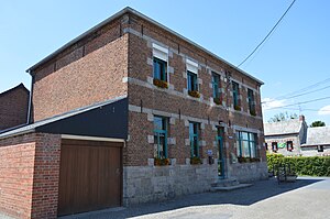
 Mairie Éclaibes |
||
Éclaibes is a commune in the French region of Hauts-de-France , in the Nord department , in the arrondissement of Avesnes-sur-Helpe and in the canton of Avesnes-sur-Helpe ( canton of Hautmont until 2015 ). It is located about eleven kilometers south of Maubeuge and borders on Limont-Fontaine in the northwest , Beaufort in the northeast, Floursies in the southeast, Dourlers in the south and Saint-Aubin in the southwest . The residents call themselves Éclaibois.
Population development
| year | 1962 | 1968 | 1975 | 1982 | 1990 | 1999 | 2008 | 2013 |
|---|---|---|---|---|---|---|---|---|
| Residents | 219 | 188 | 180 | 209 | 272 | 270 | 287 | 289 |
literature
- Le Patrimoine des Communes du Nord. Flohic Editions, Volume 1, Paris 2001, ISBN 2-84234-119-8 , pp. 801-803.
Web links
Commons : Éclaibes - Collection of images, videos and audio files
- Monuments historiques (objects) in Éclaibes in the base Palissy of the French Ministry of Culture
