
Dourlers
| Dourlers | ||
|---|---|---|
.svg)
|
|
|
| region | Hauts-de-France | |
| Department | North | |
| Arrondissement | Avesnes-sur-Helpe | |
| Canton | Avesnes-sur-Helpe | |
| Community association | Coeur de l'Avesnois | |
| Coordinates | 50 ° 11 ′ N , 3 ° 56 ′ E | |
| height | 158-205 m | |
| surface | 8.74 km 2 | |
| Residents | 569 (January 1, 2017) | |
| Population density | 65 inhabitants / km 2 | |
| Post Code | 59440 | |
| INSEE code | 59181 | |
.JPG) Mairie (Town Hall) |
||

Dourlers (NDL .: "Dorlaar") is a French municipality with 569 inhabitants (at January 1, 2017) in Nord in the region of Hauts-de-France . It belongs to the arrondissement of Avesnes-sur-Helpe and the canton of Avesnes-sur-Helpe .
Neighboring municipalities of Dourlers are Éclaibes in the north, Floursies in the northeast, Beugnies in the east, Semousies in the southeast, Bas-Lieu in the south, Saint-Hilaire-sur-Helpe in the southwest and Saint-Aubin in the west.
Population development
| year | 1962 | 1968 | 1975 | 1982 | 1990 | 1999 | 2009 |
| Residents | 746 | 748 | 710 | 622 | 582 | 567 | 551 |
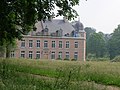
Attractions
- Church of the Immaculate Conception, built in 1859
- Dourlers Castle, Monument historique

church
lock
.JPG)
.JPG)
literature
- Le Patrimoine des Communes du Nord. Flohic Editions, Volume 1, Paris 2001, ISBN 2-84234-119-8 , pp. 136-137.
Web links
Commons : Dourlers - collection of images, videos and audio files
- Dourlers at annuaire-mairie.fr (French)
Individual evidence
- ^ De Nederlanden in Frankrijk, Jozef van Overstraeten, 1969