Gognies-Chaussée
| Gognies-Chaussée | ||
|---|---|---|

|
|
|
| region | Hauts-de-France | |
| Department | North | |
| Arrondissement | Avesnes-sur-Helpe | |
| Canton | Eye of the mouth | |
| Community association | Maubeuge Val de Sambre | |
| Coordinates | 50 ° 20 ′ N , 3 ° 57 ′ E | |
| height | 122-158 m | |
| surface | 7.94 km 2 | |
| Residents | 752 (January 1, 2017) | |
| Population density | 95 inhabitants / km 2 | |
| Post Code | 59600 | |
| INSEE code | 59264 | |
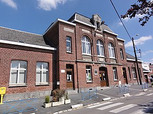
 Mairie and Schoolhouse |
||
Gognies-Chaussée is a commune in the French department of Nord in the region of Hauts-de-France . It belongs to the canton of Maubeuge ( canton Maubeuge-Nord until 2015 ) in the arrondissement of Avesnes-sur-Helpe .
geography
Gognies-Chaussée borders Belgium in the north . Beyond the national border is the district of Gœgnies-Chaussée belonging to Quévy . Gognies-Chaussée is therefore a divided place . The neighboring municipalities in France are Bettignies in the east, Mairieux in the southeast, Maubeuge in the south, Feignies in the southwest and La Longueville in the west.
Population development
| year | 1962 | 1968 | 1975 | 1982 | 1990 | 1999 | 2008 | 2013 |
|---|---|---|---|---|---|---|---|---|
| Residents | 886 | 907 | 756 | 807 | 820 | 796 | 798 | 781 |
Attractions
- Saint-Quentin Church
- Wayside shrines
literature
- Le Patrimoine des Communes du Nord. Flohic Editions, Volume 2, Paris 2001, ISBN 2-84234-119-8 , pp. 1236-1237.
Web links
Commons : Gognies-Chaussée - collection of images, videos and audio files
- Monuments historiques (objects) in Gognies-Chaussée in the base Palissy of the French Ministry of Culture
