Noyelles-sur-Sambre
| Noyelles-sur-Sambre | ||
|---|---|---|

|
|
|
| region | Hauts-de-France | |
| Department | North | |
| Arrondissement | Avesnes-sur-Helpe | |
| Canton | Aulnoye Aymeries | |
| Community association | Maubeuge Val de Sambre | |
| Coordinates | 50 ° 9 ' N , 3 ° 48' E | |
| height | 128-170 m | |
| surface | 6.49 km 2 | |
| Residents | 278 (January 1, 2017) | |
| Population density | 43 inhabitants / km 2 | |
| Post Code | 59550 | |
| INSEE code | 59439 | |
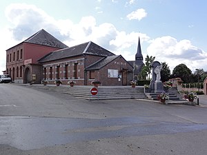
 The square with the village school, the Mairie , the church and the war memorial |
||
Noyelles-sur-Sambre is a commune in the French department of Nord in the region of Hauts-de-France . It belongs to the canton of Aulnoye-Aymeries (until 2015 canton of Berlaimont ) in the arrondissement of Avesnes-sur-Helpe . The residents call themselves Noyellais or Noyellaises.
The border with Sassegnies in the northwest and in the north runs along the Sambre . This takes up the Helpe Majeure as a right tributary after it has crossed the municipality of Noyelles-sur-Sambre. The other neighboring communities are Leval and Dompierre-sur-Helpe in the northeast, Taisnières-en-Thiérache in the southeast, Maroilles in the southwest and Locquignol in the west.
The former Route nationale 359 leads via Noyelles-sur-Sambre.
Population development
| year | 1962 | 1968 | 1975 | 1982 | 1990 | 1999 | 2008 | 2013 |
|---|---|---|---|---|---|---|---|---|
| Residents | 356 | 335 | 385 | 371 | 351 | 335 | 326 | 304 |
Personalities
- Marcel Gromaire , painter (representative of picture weaving ) and graphic artist , * 1892 in Noyelles-sur-Sambre, † 1971 in Paris
literature
- Le Patrimoine des Communes du Nord. Flohic Editions, Volume 1, Paris 2001, ISBN 2-84234-119-8 , pp. 299-300.
Web links
Commons : Noyelles-sur-Sambre - Collection of images, videos and audio files
- Monuments historiques (objects) in Noyelles-sur-Sambre in the base Palissy of the French Ministry of Culture
