
Saint-Hilaire-sur-Helpe
| Saint-Hilaire-sur-Helpe | ||
|---|---|---|
.svg)
|
|
|
| region | Hauts-de-France | |
| Department | North | |
| Arrondissement | Avesnes-sur-Helpe | |
| Canton | Avesnes-sur-Helpe | |
| Community association | Coeur de l'Avesnois | |
| Coordinates | 50 ° 8 ′ N , 3 ° 54 ′ E | |
| height | 140-206 m | |
| surface | 15.41 km 2 | |
| Residents | 823 (January 1, 2017) | |
| Population density | 53 inhabitants / km 2 | |
| Post Code | 59440 | |
| INSEE code | 59534 | |
_mairie.jpg) Mairie (Town Hall) |
||

Saint-Hilaire-sur-Helpe is a commune in the French department of Nord in the region of Hauts-de-France . It belongs to the canton of Avesnes-sur-Helpe (until 2015 canton Avesnes-sur-Helpe-Nord ) in the Arrondissement of Avesnes-sur-Helpe . The residents call themselves Saint-Hilairois.
geography
The place borders in the northwest on Monceau-Saint-Waast (point of contact) and Saint-Remy-Chaussée , in the north on Saint-Aubin , in the northeast on Dourlers (point of contact), in the east on Bas-Lieu and Avesnes-sur-Helpe , in South-east on Haut-Lieu , in the south-west on Cartignies and Petit-Fayt and in the west on Dompierre-sur-Helpe .
The former Route nationale 351 leads via Saint-Hilaire-sur-Helpe.

The Helpe Majeure at Saint-Hilaire-sur-Helpe

Marienkapelle ( Chapelle de Marie ), Monument historique near the village church
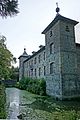
Château de Coutant , Monument historique
_moulin_%C3%A0_Fuchau.jpg)
_chapelle_de_Marie_devant_l%27%C3%A9glise.jpg)


Population development
| year | 1962 | 1968 | 1975 | 1982 | 1990 | 1999 | 2007 | 2013 |
|---|---|---|---|---|---|---|---|---|
| Residents | 927 | 915 | 842 | 833 | 846 | 779 | 773 | 781 |
Architectural monuments
See: List of Monuments historiques in Saint-Hilaire-sur-Helpe
literature
- Le Patrimoine des Communes du Nord. Flohic Editions, Volume 1, Paris 2001, ISBN 2-84234-119-8 , pp. 160-162.