
Eppe-Sauvage
| Eppe-Sauvage | ||
|---|---|---|
.svg)
|
|
|
| region | Hauts-de-France | |
| Department | North | |
| Arrondissement | Avesnes-sur-Helpe | |
| Canton | Fourmies | |
| Community association | Sud Avesnois | |
| Coordinates | 50 ° 7 ' N , 4 ° 11' E | |
| height | 172-257 m | |
| surface | 16.67 km 2 | |
| Residents | 267 (January 1, 2017) | |
| Population density | 16 inhabitants / km 2 | |
| Post Code | 59132 | |
| INSEE code | 59198 | |
 Mairie Eppe-Sauvage |
||

Eppe-Sauvage is a commune in northern France . It belongs to the Hauts-de-France region , the Nord department , the Avesnes-sur-Helpe arrondissement and the Fourmies canton . The residents call themselves Eppois or Eppoises .
geography
The Helpe Majeure flows through the municipal marker and in the Lac du Val Joly reservoir to the west of Willies . The other neighboring communities in France are Felleries in the northwest, Moustier-en-Fagne in the southeast and Trélon in the south. Eppe-Sauvage borders Belgium to the north and east .
Population development
| year | 1962 | 1968 | 1975 | 1982 | 1990 | 1999 | 2008 | 2013 |
|---|---|---|---|---|---|---|---|---|
| Residents | 363 | 335 | 264 | 231 | 245 | 218 | 254 | 269 |
Attractions
See also: List of Monuments historiques in Eppe-Sauvage
- Saint-Ursmar Church, Monument historique
- Wayside shrines
- Pedestrian suspension bridge
- War memorial

Saint-Ursmar church

Lac du Val Joly reservoir
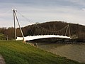
Pedestrian suspension bridge at the reservoir

Wayside shrine Le Sabot Rouge

_Lac_du_Val_Joly_(2).jpg)

_chapelle_lieu-dit_Le_Sabot_Rouge.jpg)
literature
- Le Patrimoine des Communes du Nord. Flohic Editions, Volume 2, Paris 2001, ISBN 2-84234-119-8 , pp. 1610-1612.
Web links
Commons : Eppe-Sauvage - collection of images, videos and audio files