
Willies
| Willies | ||
|---|---|---|
_Nord-France.svg)
|
|
|
| region | Hauts-de-France | |
| Department | North | |
| Arrondissement | Avesnes-sur-Helpe | |
| Canton | Fourmies | |
| Community association | Sud Avesnois | |
| Coordinates | 50 ° 7 ′ N , 4 ° 6 ′ E | |
| height | 162-230 m | |
| surface | 4.14 km 2 | |
| Residents | 148 (January 1, 2017) | |
| Population density | 36 inhabitants / km 2 | |
| Post Code | 59740 | |
| INSEE code | 59661 | |
 Mairie Willies |
||

Willies is a commune in northern France . It belongs to the Hauts-de-France region , the Nord department , the Avesnes-sur-Helpe arrondissement and the Fourmies canton . The municipality is located near the border with Belgium on the Helpe Majeure , which is dammed here to form the Lac du Val de Joly reservoir. It borders in the north on Felleries , in the northeast on Clairfayts (point of contact), in the east on Eppe-Sauvage , in the south on Trélon and in the west on Liessies .
Population development
| year | 1962 | 1968 | 1975 | 1982 | 1990 | 1999 | 2008 | 2013 |
|---|---|---|---|---|---|---|---|---|
| Residents | 134 | 137 | 107 | 105 | 128 | 139 | 158 | 159 |
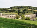
Lac du Val Joly reservoir
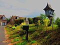
Dovecote
_barrage_Lac_du_Val_Joly.jpg)

literature
- Le Patrimoine des Communes du Nord. Flohic Editions, Volume 2, Paris 2001, ISBN 2-84234-119-8 , pp. 1644-1645.
Web links
Commons : Willies - collection of pictures, videos and audio files