Sepmeries
| Sepmeries | ||
|---|---|---|

|
|
|
| region | Hauts-de-France | |
| Department | North | |
| Arrondissement | Avesnes-sur-Helpe | |
| Canton | Avesnes-sur-Helpe | |
| Community association | Pays de Mormal | |
| Coordinates | 50 ° 17 ′ N , 3 ° 34 ′ E | |
| height | 53-106 m | |
| surface | 5.99 km 2 | |
| Residents | 663 (January 1, 2017) | |
| Population density | 111 inhabitants / km 2 | |
| Post Code | 59269 | |
| INSEE code | 59565 | |
| Website | http://www.sepmeries.fr/ | |
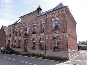
 Mairie Sepmeries |
||
Sepmeries is a French municipality with 663 inhabitants (as of January 1 2017) in Nord in the region of Hauts-de-France . It belongs to the canton of Avesnes-sur-Helpe (until 2015 canton Le Quesnoy-Ouest ) in the arrondissement Arrondissement Avesnes-sur-Helpe . Sepmeries is bordered by Artres to the north-west, Maresches to the north-east, Villers-Pol to the east, Ruesnes to the south-east, Bermerain to the south-west and Vendegies-sur-Écaillon to the west .
Infrastructure
The railway line from Aulnoye-Aymeries to Valenciennes runs through Sepmeries . The nearest train station is in Le Quesnoy.
Population development
| year | 1962 | 1968 | 1975 | 1982 | 1990 | 1999 | 2006 | 2013 |
| Residents | 578 | 593 | 587 | 562 | 489 | 523 | 555 | 677 |
| Source: Cassini, EHESS and INSEE | ||||||||
Attractions
- Saint-Côme et Saint-Damien church from the 19th century
- old hotel building, monument historique
- War memorial
Personalities
- Michel Bernard , middle and long distance runner (1931–2019)
literature
- Le Patrimoine des Communes du Nord. Flohic Editions, Volume 2, Paris 2001, ISBN 2-84234-119-8 , pp. 1357-1358.
Web links
Commons : Sepmeries - collection of pictures, videos and audio files
- Monuments historiques (objects) in Sepmeries in the Base Palissy of the French Ministry of Culture

