Englefontaine
| Englefontaine | ||
|---|---|---|

|
|
|
| region | Hauts-de-France | |
| Department | North | |
| Arrondissement | Avesnes-sur-Helpe | |
| Canton | Avesnes-sur-Helpe | |
| Community association | Pays de Mormal | |
| Coordinates | 50 ° 12 ′ N , 3 ° 39 ′ E | |
| height | 128-152 m | |
| surface | 4.62 km 2 | |
| Residents | 1,304 (January 1, 2017) | |
| Population density | 282 inhabitants / km 2 | |
| Post Code | 59530 | |
| INSEE code | 59194 | |
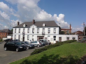
 Town hall building (Mairie) with post office and community hall |
||
Englefontaine is a commune in northern France . It belongs to the region of Hauts-de-France , the Nord , for Arrondissement Avesnes-sur-Helpe and Canton Avesnes-sur-Helpe (2015: District of Le Quesnoy-Est ). The residents call themselves Englefontainois .
geography
Englefontaine is about 19 kilometers east of Cambrai . Englefontaine is surrounded by the neighboring communities Louvignies-Quesnoy in the north, Raucourt-au-Bois in the northeast, Locquignol in the east, Hecq in the south and Poix-du-Nord in the south and west.
Population development
| year | 1962 | 1968 | 1975 | 1982 | 1990 | 1999 | 2006 | 2013 |
|---|---|---|---|---|---|---|---|---|
| Residents | 1,189 | 1,323 | 1,337 | 1,349 | 1,354 | 1,327 | 1,343 | 1,298 |
| Source: Cassini and INSEE | ||||||||
Attractions
- Saint-Georges church
- Saint-Georges fountain from 1948
- British military cemetery
literature
- Le Patrimoine des Communes du Nord. Flohic Editions, Volume 2, Paris 2001, ISBN 2-84234-119-8 , pp. 1318-1320.
Web links
Commons : Englefontaine - collection of images, videos and audio files
- Monuments historiques (objects) in Englefontaine in the base Palissy of the French Ministry of Culture

